One More To Go...Then Relief!
Find Eric Fisher on Twitter and Facebook
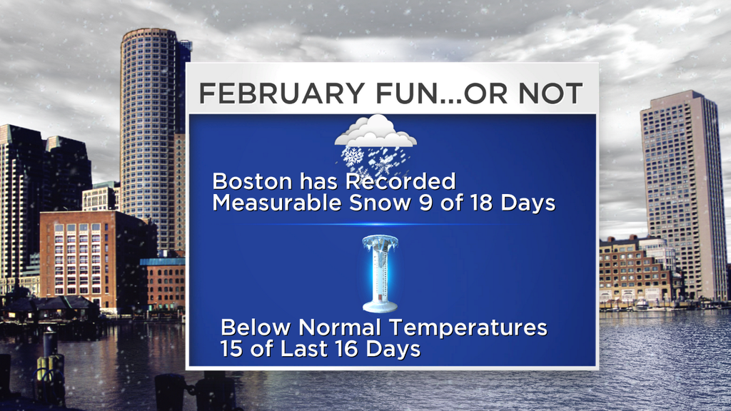
Well, that escalated quickly. A potent upper-level system did plenty to coat the area in snow yet again today. And yes, I will readily admit there was more than expected in some towns. In particular, a few of the suburbs to the west of Boston and up across the Merrimack Valley into NH. We had a 6"+ area last evening into NH, but that didn't do is justice! Some popped up to near a foot of fresh snow. The cold air from last night (subzero to single digits) did not scour out, the snow was extra light and fluffy at a 20:1 ratio, and it certainly had no issue piling up. Some of the pictures are incredible! Meanwhile everyone near the coast stayed in the 1-4" range due to warmer lower levels and wetter consistency. Most towns NW of the Cape Cod Canal were busy plowing yet again.
For the full round-up on today's snow, you can visit the National Weather Service site. The seasonal numbers are getting up there, but still not near record territory. Still some time to go, and it will be interesting to see where this season ends up.
Boston - 2.5" today, 56.0" for the season
Worcester: 5.7" today, 38.2" for the month, 77.6" for the season.
Providence: 3.7" today, 41.8" for the season.
The storm parade continues tomorrow as yet another potent vort-max goes negative tilt and swings up across eastern New England. There are some differences this time around though. The air mass above our heads is expected to be a little warmer, meaning that snowflakes will melt on the way down for many towns. The surface temperatures won't go as cold tonight, and so we'll be starting with milder air tomorrow morning. And so the overall theme is for more rain than snowfall.
We may manage a little morning sun before the clouds thicken back up. Rain and wet snow should start to move into western Mass and CT by mid to late morning, and will expand across our area by lunch and early afternoon. This should be an all-rain event for Greater Boston and inside I-95, with perhaps just some wet flakes mixing in at the tail end Wednesday evening. That being said, some pockets of moderate to heavy rain on top of a bunch of snow is never fun. There could be some poor drainage flooding, lots of standing water, and certainly a good candidate for galoshes.
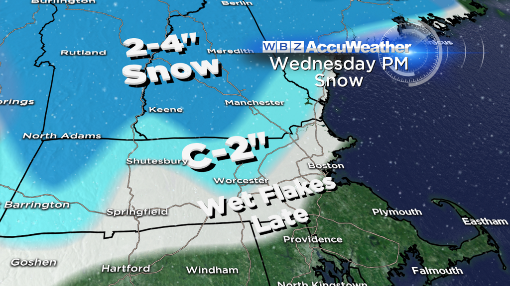
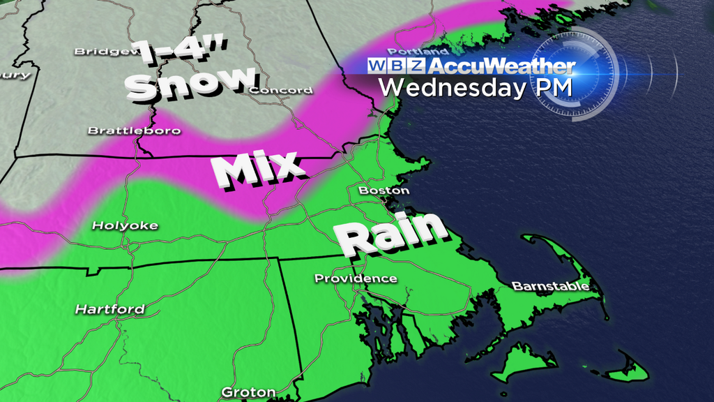
The area we'll have to monitor most closely is the northern half of Worcester County, northern Middlesex County, and northward into New Hampshire and Vermont. The thermal profile is so close to being snow that I don't doubt we could be shoveling in a few towns again. Hey in this winter, may as well ride the trend right? Especially considering there will be a good burst of lift in the atmosphere and the system looks quite vigorous. So in those areas we could see another inch or two, and certainly much more into New Hampshire and Maine where ski areas will yet again be pummeled by fresh snow. An embarrassment of riches lately!
Okay...the break you've all been waiting for? It gets here on Thursday. Not exactly tropical, but after morning fog we should jump up into the low 40s with sunshine and clouds mixing together in the sky. Could be worse, that is for sure! A great day for spending on the slopes, and much easier to handle no matter where you are. It's truly the quietest day of our forecast with some clouds moving in late in the day.
Thursday night into Friday a warm front lifts northward from a strong storm in the middle of the Nation (which will bring severe weather to areas south of New England). We'll still be on the cool side of this, and it bears watching for some potential icing around the Route 2 corridor and into NH/VT. There could be a decent batch of icing in northern New England overnight and into early Friday morning, mixed in with some snow. There will also be a lot of fog around Thursday night as mild air tries to move in over the snowpack...so expect some pretty gloomy travel conditions.
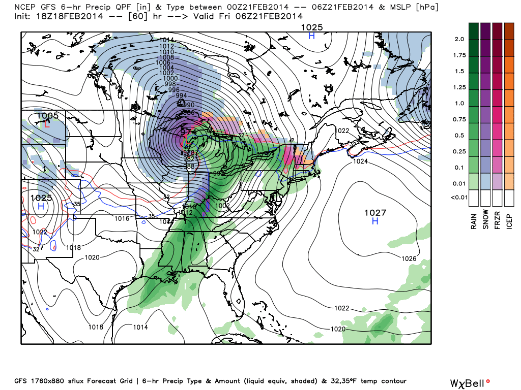
Thursday night setup as seen by the 18z GFS on Tuesday. Source: WeatherBell
On Friday itself the warm front should be able to push north of MA, but it'll be tough around the Merrimack Valley and North Shore (and points north). So while you've seen that 50º on the 7-Day for a while, we probably will not get there for northern MA. More like the 40s. But Boston southward should manage the 50s on gusty southerly winds. There will also be some rain squalls about, perhaps even some thunder. A feel of spring! The attendant cold front will swing through during the afternoon/evening and bring a final dousing. It doesn't look like enough to cause major flood issues, but poor drainage flooding will be a problem.
The weekend? Not too shabby. The air behind this front isn't Arctic, so we'll still be in the 40s with a breeze and lots of sunshine on Saturday. Overall, one of the better days in our forecast for the next two weeks, so soak it in! On Sunday an upper-level impulse should bring a few rain/snow showers and more cloud cover than Saturday will have.
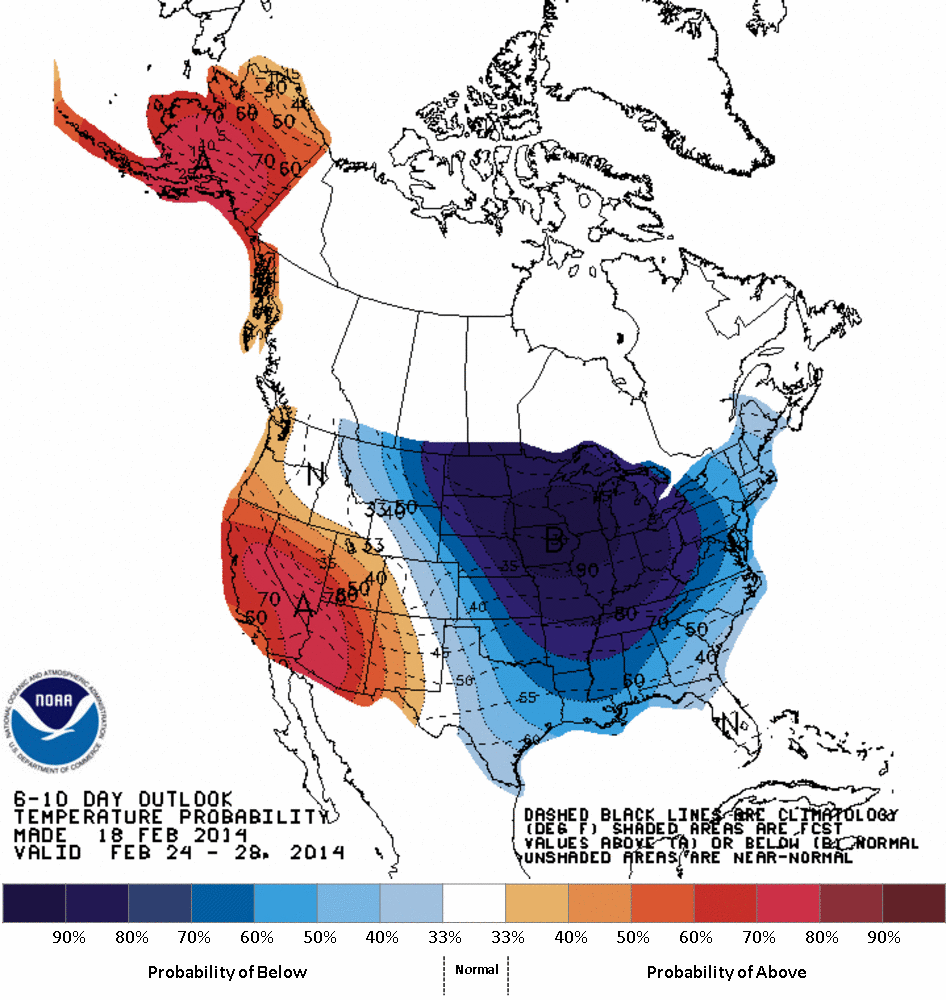
The party is already over (I just got here?) by Monday. An Arctic front crashes through, bring some flurries, and holds us in the 20s. By Tuesday, our 850mb temps are in the -18 to -23ºC range, which means it will be downright frigid and unusually cold for the end of February (where the average high is 40 in Boston). And here's a familiar foe - most models indicate some storminess developing along that leading edge of Arctic air. That's something that's very typical, but the question is does that storm trend farther west over time? The answer has been a resounding yes for all the rest of the storms this year, so that's the time frame we're watching next for potential significant snow.

A familiar scene depicted by the 18z GFS today. A much colder than average eastern U.S. next week. Source: WeatherBell
After that, most models are on board with a huge cold air outbreak for the central and eastern U.S. Probably not what you wanted to hear at the moment, but it looks like winter is nowhere near done with us yet. But Daylight Saving Time is only 19 days away, and the official start of spring is just a touch over a month away. The Sox are stretching in Fort Myers and before you know it a crocus or two will be popping up in the yard. Keep the faith.
Source: NOAA


