Storm, Storm, Everywhere A Storm
Find Eric Fisher on Twitter and Facebook
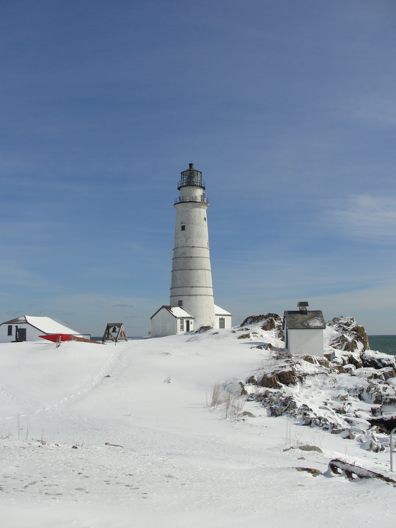
Stunning Boston Light today from Keeper Sally Snowman (yes, that is her real name)
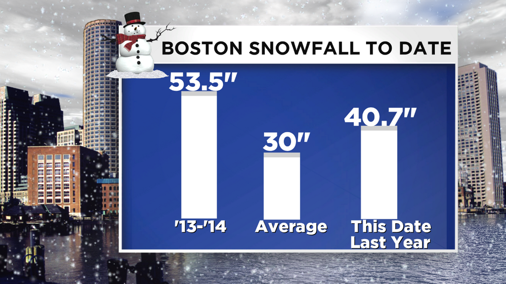
Well, perhaps it at least feels that way this winter? While blockbusters haven't been the rule, there have been plenty of 'plowable' events so far this winter. Great for plow operators, not great for municipal budgets. There have been at least 8 of them, depending on where you live (past events here). And yes, another looks quite likely for Tuesday. However, we're still not very close to anything historic yet. The 53.5" in Boston thus far is still 12.5" away from reaching Top 10 Snowiest Winter status, and 54.1" away from king of the mountain (107.6" back in the epic winter of 1995/96). I'm sayin' there's a chance, but it doesn't look too likely.
Before the next event, it's just another cold night here in New England. Clear skies and diminishing wind should let many suburbs get down into the single digits, some near 0, while the coast stays in the 10s. Clouds out ahead of this next weather maker will cap that cooling after midnight, and in fact we'll rise into the 10s and even some 20s by early morning on Tuesday.
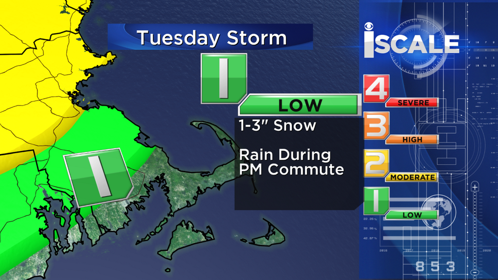
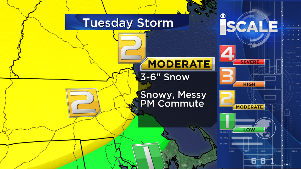
I think many of us will awake to a 'snow sky,' or at least see what develop quickly. Skies will go overcast, and the snow itself should arrive around noon for Worcester County. Quickly it'll spread over to Boston and surrounding areas, and the rates will come up to perhaps 1"/hr during the afternoon. There are a couple pros and cons to this particular storm.
Pros: School vacation week, less volume on the roads, temps near or above 32º for much of eastern MA
Cons: Timing coincides with afternoon/evening commute, poor visibility.
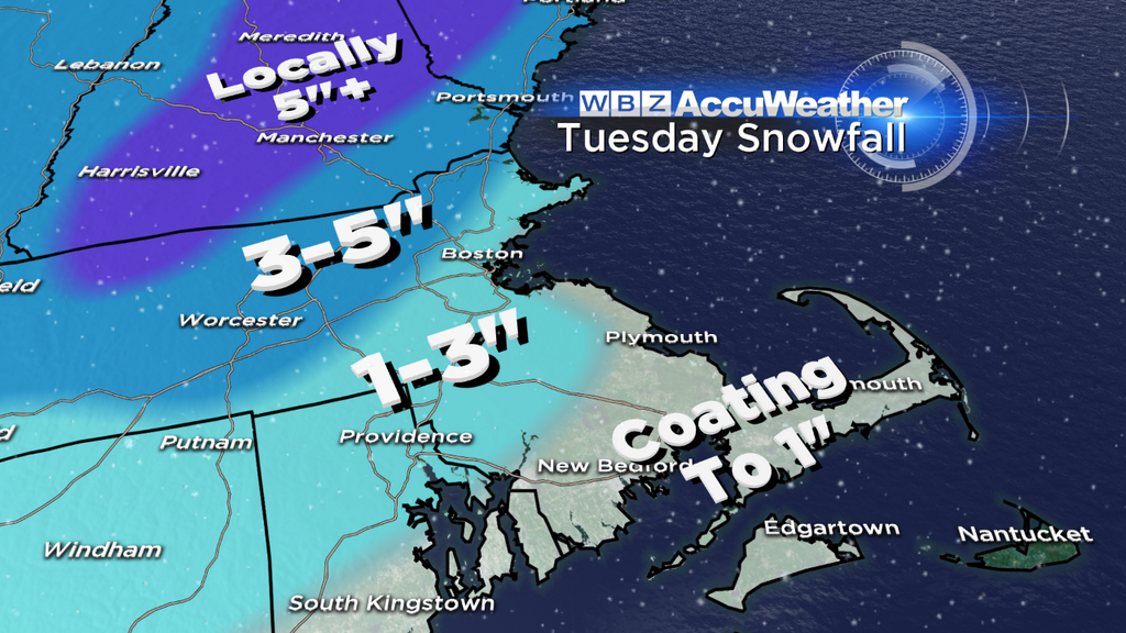
So the bottom line you can expect some nasty/slow travel through Tuesday afternoon and evening, particularly west and north of Boston where rates may be highest, temperatures will be colder, and some localized banding is most likely. There are a few towns in northern Worcester County and up into southern NH that may exceed 6" from this storm, adding on to your already high snow banks. Boston-south looks like 1-3" of wet snow, and any snow early on for the Cape back toward Buzzards Bay should change over to rainfall with temps well up into the 30s.
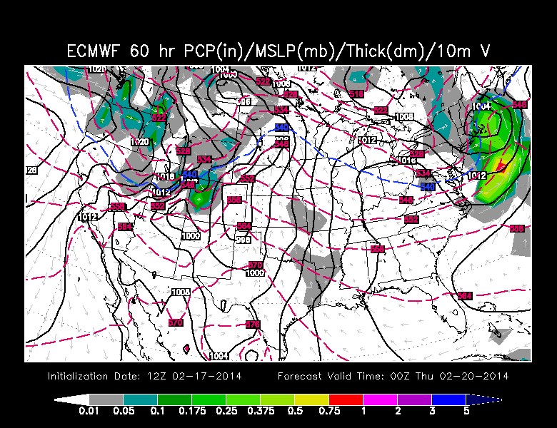
ECMWF showing quick coastal development on Wednesday evening. GFS is similar. Source: WSI Energycast
Is that the end? Looks like no. Shocking. Yet another, very similar impulse may swing up along our coast on Wednesday too. It's yet another 'quick to develop, quick to move' type of storm, and the thermal profile is a little warmer this time around. 850mb temps are between -1 and +2C across the area, very borderline. At the surface we should be up into the 30s too. So this may end up being more rain showers than anything else. But if rates can get up there and the storm deepens fast enough we may have more snow to deal with in interior MA. So expect another damp, and possibly white drive home on Wednesday.
But aha! Thursday comes, and yes Virginia there is a Santa Claus. We have a shot at topping 40º. It's a miracle! Well, not quite, but 13 of the past 14 days have featured below average temperatures in these parts and Tue/Wed will probably come in colder than average too. So a little respite may not be so much of a bad thing. A warm front will quickly be reaching out toward us in this very busy weather pattern, so cloudiness may be an issue. But I do think we'll manage some sun to mix with the clouds and let's face it - low 40s will feel great.
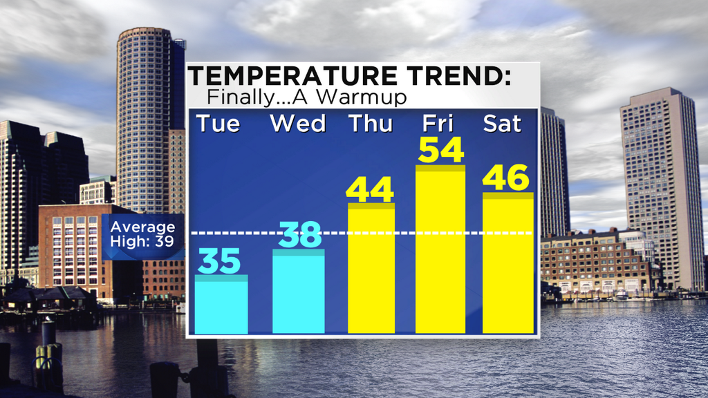
We'll do even better on Friday as that warm front swings north and allows gusty southerly winds to bring up all sorts of mild air. Temps should manage the 50s for many, especially Boston southward, before this cold front can crash the party. It comes at a cost - there will be showers and a few downpours, plus lots of cloud cover and hefty wind gusts to go along with those mild temps. But we'll take it. With all this snow on the ground, plus some rain, plus milder air, there will also likely be a lot of standing water and some poor drainage flooding to contend with.
The weekend looks pretty reasonable at the moment. While colder air will move back in on Saturday, it's not *that* cold. A gusty breeze and well-mixed atmosphere should get us back into the 40s, and we'll hover close to 40 on Sunday. So overall it could definitely be worst. But if you're already saying 'that's too warm for my ski slope' then you're in luck, because wooo boy is it going to get cold again next week. Most models are progging another big Arctic Outbreak for a large chunk of the country, including our little corner. So highs in the 20s, nights in the single digits, and perhaps another shot at snow are on the table.
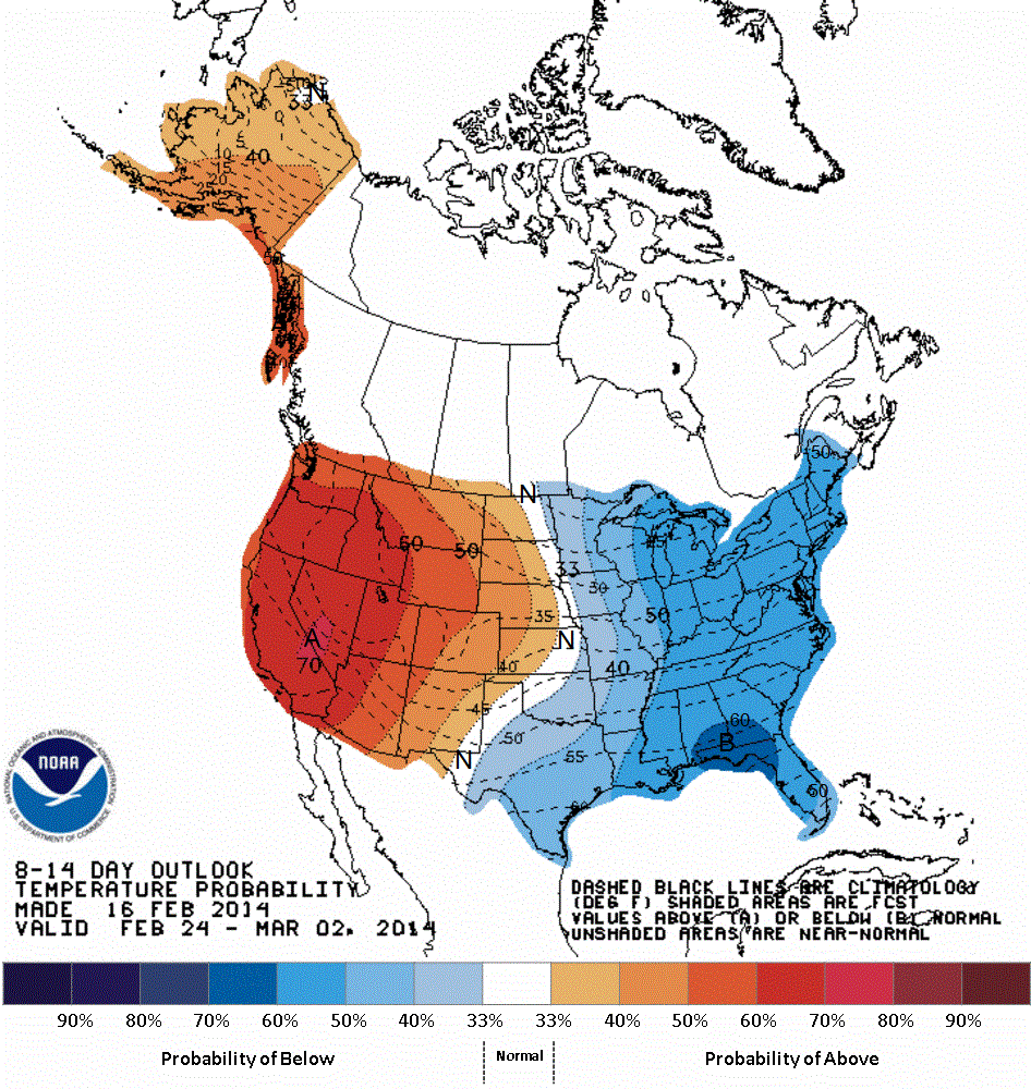
CPC outlook for days 8-14 showing high probability of below avg temps returning to the east, while warmth once again builds in the west. Source: NOAA