1 Storm Leads To Another
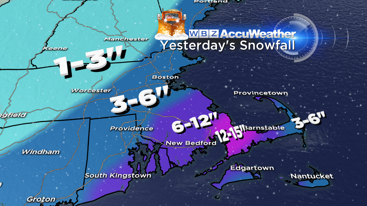 Another storm has come and gone and this one did not meet expectations in places. Our revised reduced snowfall amounts early last evening were still slightly inflated by up to 2-4 inches over parts of eastern MA. Unfolding conditions warranted us to shift the jackpot zone into extreme southern Plymouth County and western Barnstable County. Check out this snowfall list compiled by the National Weather Service and you will see that Sandwich won the prize with its 15". Despite the lower amounts, the snow was stickier and heavier down there and combined with howling winds past 50 mph last night, power outages resulted. The outer Cape also received less than anticipated but areas near and west of the I-95 corridor were right on with less than 6" down to 3" of fluffier snow into Middlesex County and Worcester County. Boston's 4" raises the seasonal total at Logan Airport to 53.5" which is close to 10" above the average total seasonal snowfall. My winter forecast released on Thanksgiving Weekend called for above average snowfall in the range of 50-60" for the city which is a bit less than the 63.4" of last season. It now appears that the seasonal snowfall will exceed that of 2012-13. Although back-to-back above average snowfall seasons do occur, statistics reveal that they are not too common. There is usually more of a variation from one year to the next such as the 96.3" in 1993-94, the 14.9" in 1994-95 and the 107.6" in 1995-96 and more recently the 81.0" in 2010-11, the 9.3" in 2011-12 and the 63.4" in 2012-13.
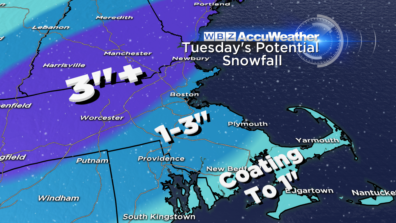 One storm leads to another and the next hit is timed for Tuesday. Present extrapolation places the snow breaking out over eastern MA near the end of the morning commute. Most of the snow will fall in the period of 10AM to 4PM. This snow will be produced by a low pressure system which is currently crossing the central Rockies. Its path will open up across the Midwest with the compact center driving up over Lake Erie then redeveloping near NYC by midday Tuesday on its way across southern CT, southern RI into southeastern MA Tuesday afternoon. The belt of heaviest snow will exist north of the MA Pike extending up into southern VT, southern and central NH into ME. In this axis, 3" up to 4-5" are probable. Along the MA Pike, near 3" is the expectation ranging down to 2 to 1" farther south down to the South Coast. The small storm will exit early Tuesday evening. That will quickly be followed by a warm frontal boundary and a cold frontal boundary arriving Wednesday releasing a brief shower in spots. Milder air should rush in lifting temperatures to the lower to middle 40s. The next weather maker will zip into the region on Friday. The parent storm will shift much farther north across the Great Lakes into southern Canada. Consequently, a surge of even milder air will occur late Thursday night into Friday. With a brisk south to southwesterly wind, temperatures should easily rise to 50-55 and any showers with the fronts will be spring-like. Following the cold frontal passage by midday, it will only be slightly cooler on Saturday. The next storm will arrive late next Saturday. It is too premature to be confident of specifics regarding this system but right now it looks like the northern mountains may get some decent snow with southern New England having mostly rain with a bit of snow at the start and/or at the end. Sunny days will be tomorrow with highs near 30 amidst a cold, gusty morning wind and Thursday with afternoon highs in the middle 40s when cloudiness appears in the western sky.
Several emails and tweets confirm that lots of people are out this holiday weekend enjoying the dynamite conditions on all trails via snowmobiles, snow shoes, alpine or Nordic skis and snowboards. Recent decent snows have produced the best conditions of the whole winter just in time for the school vacation week. Most all of the terrain is finally open everywhere including the glades and shoots. Please operate in control and be courteous out there on the trails. I can't wait to get out there myself!
Todd Gutner posts his thoughts tomorrow morning and Eric Fisher follows later in the day.
Enjoy the rest of the long holiday weekend!