Kitchen Sink Storm Moving In
Find Eric Fisher on Twitter and Facebook
Pure snowstorms - perfect. Something magical about a wide-scale blanket of snow covering the region. Great for sledding. Skiers rejoice. Maybe cancel school for a day. Lovely.
Storms like what we're expecting tomorrow? Not so much. While it won't be the biggest in terms of snowfall for most, it will likely be the biggest pain for forecasters and everyone living through it. Lots of variables with a low that won't take the typical Nor'easter route. Instead, a track farther to the west, dragging the 850mb low over parts of Southern New England and wrapping in mild air as it matures. What does that mean? A wide variation in impact across our relatively small area.
Let's start with what this storm has been up to already. In the south, it is a complete and utter mess. While Atlanta did a great job of just keeping everyone home this time (golf clap!), Raleigh did not. Cars have been abandoned, track jams abound, and people are stranded. When will people listen? Then you have the ice component, which has brought power loss to hundreds of thousands of customers, particularly in the I-20 corridor from Atlanta, GA through Columbia, SC. And particularly tough to swallow is the cold. A lot of folks down south will be sitting and staring at that ice for a while, with temperatures well below average into the start of next week (30s and 40s for highs). So - it could be worse.
For us, a complicated forecast which certainly may be reduced to 'nowcasting' during the day tomorrow if Mother Nature gets cranky (it's good to be honest up front, right?). Conditions will be changing throughout the day and into the night, so here's a look at some of the details as I see them right now.
Timing:
The initial batch of snow should move in from south to north between 5am and 8am. While many of the models have been wavering on when this transpires and what precipitation type we'll be dealing with, I think it'll be all snow early on and then quickly transition to rain for the Cape/Islands and South Coast. 1-3" may fall before that change happens. North of the Mass Pike, you're O.K. for the commute if you leave on the early side (before 7a). It should end up dicier from the Pike - South.
By midday, heavy snow/rain rates should be in place. The heaviest snow will be just west of Boston through much of central and northern MA. By early afternoon it should be all rain for most of SE Mass, from the Scituate area down to the coast and Cape.
From the late morning till late afternoon snow rates could reach 1-2" per hour, particularly in eastern MA, central MA and NH. The mix line will be very close to 128 at this point. Heading into the evening, sleet and freezing rain will be working its way out into the Worcester area and up toward Route 2, the pure snow retreating to NH and VT. We should be seeing mostly rain inside of 128 and south of the Pike at this point.
In the evening and first half of the overnight, the precip shield will empty out a bit. This is likely a period of icing/sleet for the interior, and mostly rain for Boston, the coast, and SE Mass. Total totals, a measure of instability, are very high into the overnight and so thunderstorms may develop across SE Mass!
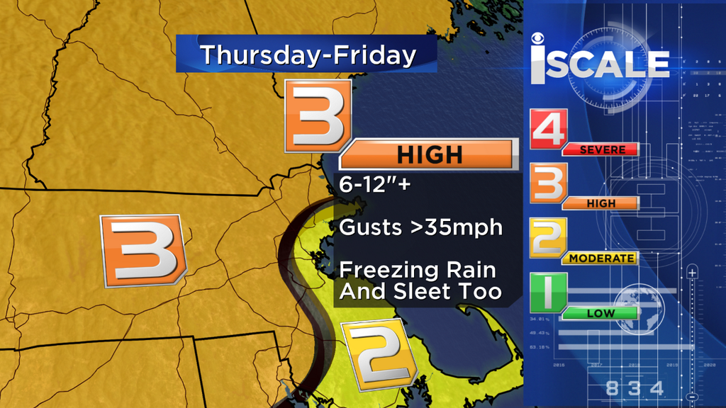
And finally from midnight through early Friday morning the 'comma head' part of the storm, where moisture wraps around the mature and powerful Nor'easter, should come through central MA, areas north of Boston, and southern NH. There's a lot of uncertainty about if/where this will occur. But this is part of what we're banking on to get into the 10-16" range. It all wraps up by approx commute time Friday, but if this last gasp of wrap-around moisture comes through there will be some tough driving conditions NW of Boston.
Snow Totals:
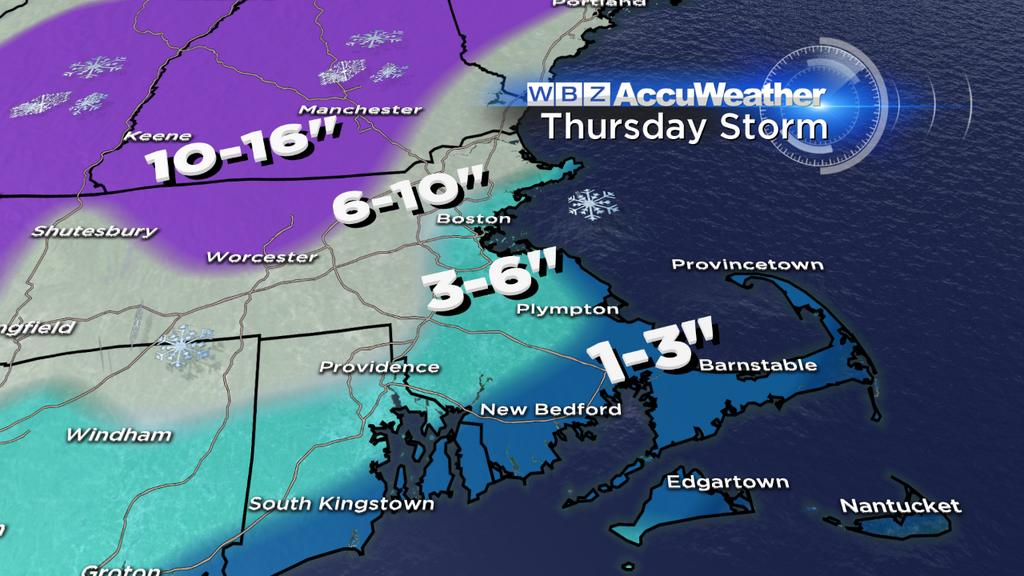
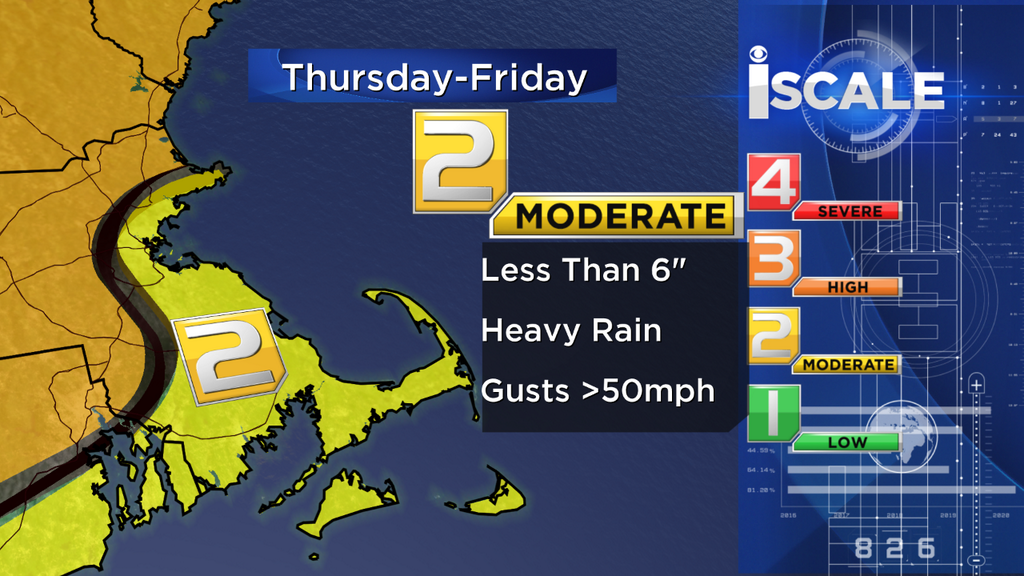
The snow only tells part of the story with so much mixing, etc, but here's a look at what we expect before it all ends. The highest potential for over 10" looks to be northern Worcester Co., potentially NW Middlesex Co., southern/central NH, and back toward southern VT and the Berkshires. 6-10" is the forecast for Metro West, and I'd say this is probably the biggest 'bust' potential depending on how quickly mix gets involved. 3-6" looks likely in Metro Boston + inside 128, closer to 3" near the water and 6" near 128 itself. Some models barely bring any snow at all into Boston, and certainly that's a possible outcome. In any case, I do NOT expect it to be a major snow event for the city or surrounding areas to the north and south. The 1-3" totals area will likely turn to slush and melt with all the rain following it.
Coastal:
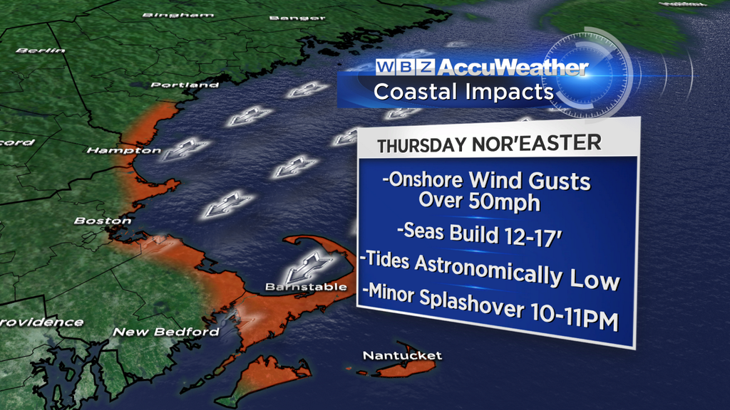
A lucky aspect to this storm is that astronomical tides are low. Not the lowest of the month, but about 3' lower than the highest tide of the month. Since we have such large (~10' in many locations) tidal fluctuations, this is always a key factor in forecasting coastal flooding. So with the low astro tides, we're only anticipating minor coastal flooding and splashover. This would be most likely during the 10-11pm high tide cycle. The seas will be rough though, 12-17', and strong gusts will make for a fairly wild scene at the shore.
Winds:
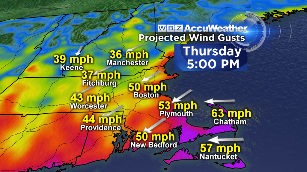
Wind will be a more widespread issue this time around than many of our recent events. This low will undergo 'bombogenesis,' meaning a drop of at least 24mb in 24 hours. Now IF there was a solid area of high pressure over Quebec, we'd be talking hurricane force winds. Strong winds are found where pressure gradients, or change over distance, are highest. With this low bombing out to around 973mb, you've got impressively low pressure sitting off the coast. But without a strong high to increase that gradient, you avoid the truly damaging winds. That being said, coastal areas may gust over 60mph Thursday afternoon and evening, with a second blast of 60+ potential during the overnight across Cape Ann. And even in the interior, where wet snow may cling to limbs and power lines, winds will gust over 35mph. So sct'd outages are definitely an issue that may develop this time around, which is unlike all the other storms this season.
Flooding Rain Threat:
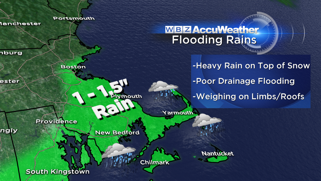
When we look out of all our windows, we all see snow right now. So adding on 1-1.5" of rain isn't exactly a silver lining. While you may not be doing much plowing from the South Shore to the Cape/Islands, localized flooding will be a problem. Lots of standing water is expected, poor drainage flooding will result, and a lot of folks will have to keep an eye on rooftops and cellars. If you can clear snow away from drains, that would be most helpful! Quite a slushy mess will result from Thursday's storm.
Icing Issues:
While the ECMWF has trended colder, the models we use in general are all over the place in terms of thermal profile. Some bring in widespread mild air (origin from the tropics getting wrapped into the storm) aloft, so that rain falls down and freezes in the cold air near the surface. With very cold temperatures tonight, it will be tough to scour out cold air in the interior where snow is also deep already. So if this mild air invades a few thousand feet up, we're talking about sleet and freezing rain. The potential doesn't look high enough for widespread outages, but it could make travel extra slick and create an extra hassle in the clean-up efforts. This highest risk for icing will be late in the afternoon through the first half of the overnight, and may extend all the way west to the CT River Valley.
Track:
Lots of hand-wringing over this for the past few days. Anyone who's lived here for a while knows little differences can mean big changes in who gets what. The RPM is extremely warm, the NAM is colder, the GFS has moved west over recent days, and the ECMWF trended a little colder today. Being a Meteorologist is fun, right? So what happens? What looks most likely to me is a storm center which passes over Cape Cod Thursday night, bringing mild low and mid-level air across much of eastern MA. Not a classic snow track. This is why most of the heaviest snow falls to our NW in the truly cold air and in the best 700mb deformation zone. It's a little strange to have such a strong storm track that far west, but that's what we've got! This will continue to deepen in the Gulf of Maine on Friday morning before heading up toward Nova Scotia.
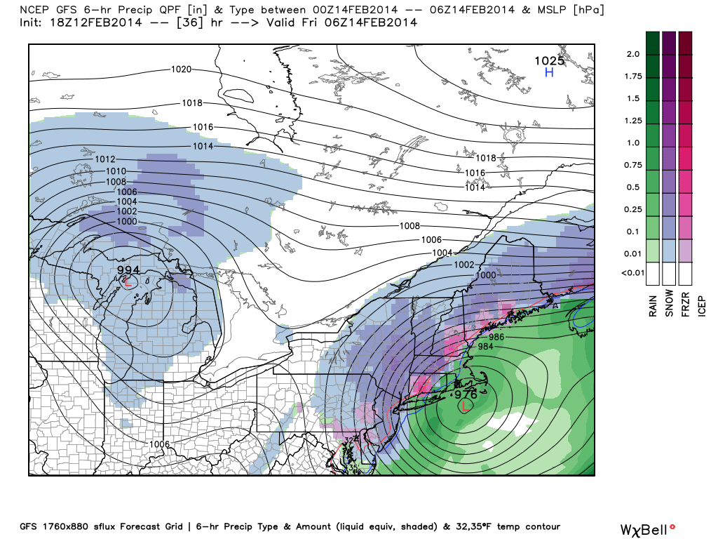
Source: WeatherBell
What's Next?
Yet another vort-max flies down to our south on Saturday and tries to quickly develop near our coast. Close enough to keep an eye on, that's for sure. Right now it looks like some clouds and areas of snow showers/light snow, especially SE Mass. This system will help drag down more very cold air for Sunday and Monday. The fun never stops! Yet another storm system approaches on Tuesday, but indications are this low will pass through the Great Lakes and drag milder air into Southern New England. While we may get some mix, I'm leaning predominantly rain for now. And late next week? A WARM-UP. You read that right. It looks like 40s and 50s will lead us into the weekend. We deserve it.


