Another Week, Another Potential Storm
Find Eric Fisher on Twitter and Facebook
Nothing like starting off Monday with another storm threat looming! Winter has been a busy one and will keep on walking the same path for at least another week or so. Before this one gets to us it will lead to all manner of wintry mess in the south. It's been a really rough year for the southern states, as it takes much less snow/sleet/ice there to bring a major impact than it does around here. And yes, Atlanta will be in the bulls-eye again. Many friends have already been posting all sorts of photos on FB of empty shelves, huge lines, people generally losing their minds. Safe to say they're taking this one a little more seriously than the last.
First things first - the cold. It's been cold, it's staying cold. Many areas will drop back into the single digits tonight, and a few isolated towns may even go subzero for a short time. Thank clear skies and temps falling to -19C at 850mb, the coldest we've had in a while. The one thing working against REALLY cold temperatures is the fact that a light breeze should keep active overnight. But lots of stars overhead as any daytime cloudiness dissipates.
The core of this most recent cold sits over us on Tuesday, and it will indeed be the coldest day for quite a while. Highs will struggle to top the low 20s, even with abundant sunshine. Most models suggest a well-mixed atmosphere too, which means a gusty breeze should develop and hold wind chill values in the 0s/10s throughout the day. Lots of layers again...we've got that routine down pretty well by now. High pressure crests over New England Tuesday night, which means it'll be ripe for radiational cooling. What in the world is that? Not as ominous as it sounds. Clear skies + calm winds + snow pack = perfect radiational cooling. Any heat from the day will head right back up into space as the atmosphere 'decouples.' Could be quite a few subzero temps out there during the overnight, with everyone else in the single digits. Great for those who want ice to stay on local lakes/ponds for a while!
Wednesday is the calm before the storm...lots of sunshine and calm winds (less wind chill!). The harbinger of changing weather, a veil of cirrus clouds, should move overhead as evening approaches. At this point, most of Wednesday night looks dry. Many models hint at the start of our next storm not arriving until early Thursday. So any plans this week through at the very least Midnight Wednesday into Thursday should be fine.
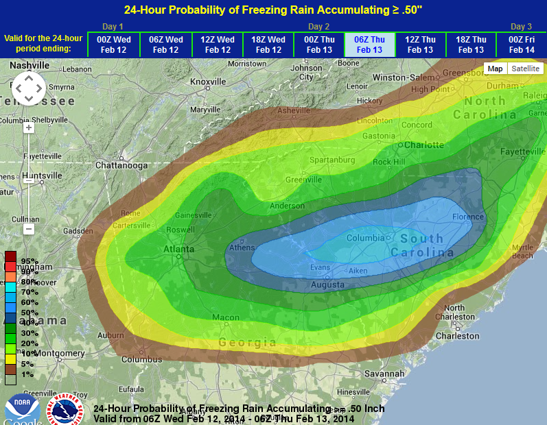
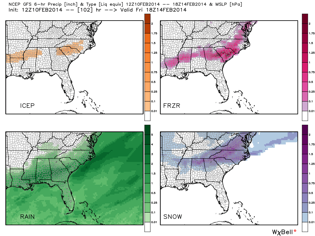
Above: Ice accumulation probabilities from the WPC. Major ice storm potential from Atlanta eastward and up toward Charlotte. To the right of that is a GFS forecast for accumulated sleet, freezing rain, rain, and snow. Quite a mess across the southeast. Source: WeatherBell
One thing to note about this next batch of disruptive weather - if you have flights in/out of Atlanta, Birmingham, Charlotte, Columbia, Raleigh, or Richmond - check ahead. There are likely going to be a lot of cancellations across much of the south due to ice and snow, in particular Wednesday and Thursday. The Atlanta area may even end up seeing their worst ice storm in 10-20 years. I was told by former colleagues they tested out all the redundancy systems and power generators today to prepare (their HQ is outside Atlanta). Could end up being a real mess if freezing rain predictions stay on track (over 1/2" of accumulation).
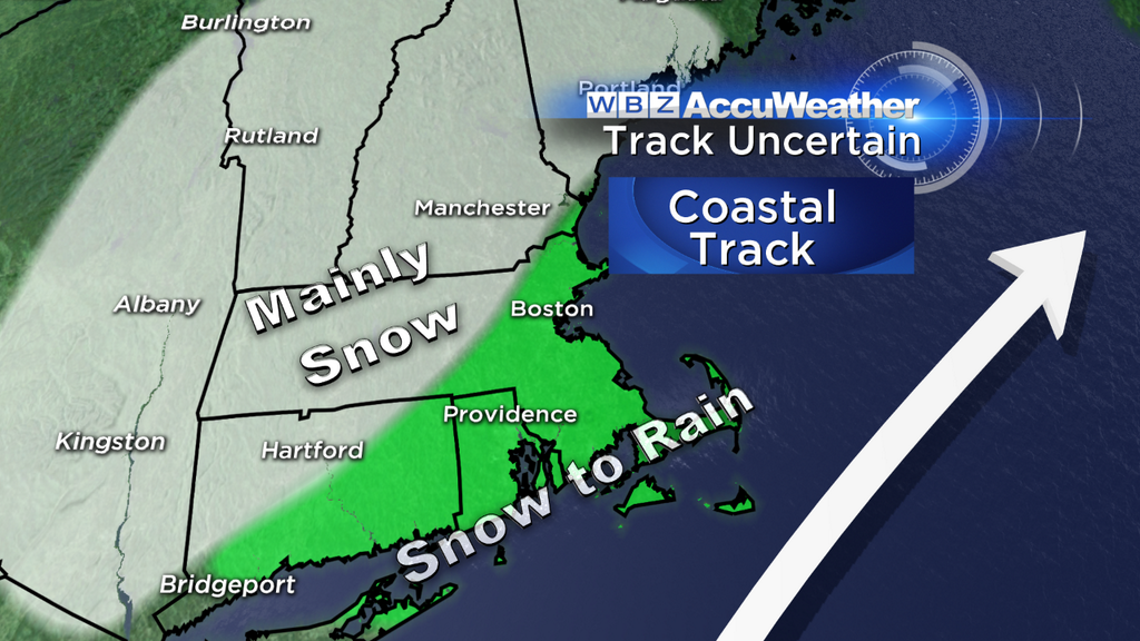
For us, the picture hasn't completely come into focus yet. We know that Thursday is the day to watch, and that this system should produce a mix of rain and snow. But as is typical 3 days out, there are questions about the intensity, exact track, and where those battle lines may end up being drawn. The ECMWF camp is an 'inside' solution - which brings in a LOT more warm air and a significant amount of rain and/or ice vs snow for the Boston area and SE Mass. Any areas that stay completely with snow would be far into the interior. However, its ensemble mean is a bit farther east. The GFS model is much farther east indeed, and brings a much snowier solution for the area. It's the outlier right now, and seems to be a little out to lunch. Looking at its ensemble members, there are quite a few, even now, that are a complete miss! That situation looks unlikely.
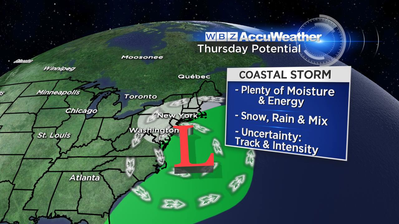
So for now, plan on a messy Thursday with a wintry mix moving in. This storm will most likely feature a typical to wet snow ratio, and will also most likely bring rain into the Cape and Islands. Wind will be a bigger factor with this one than the storm we saw last week. Strong gusts over 35mph are looking highly likely, especially late Thursday into Friday morning. So if there's very wet snow we could end up with some power outages. Coastal flooding does not look to be in the cards for the most part. Astronomical tides are on the low side, and wind direction should be changing through the storm at a fast enough rate to avoid major issues.
The most likely scenario right now. Still 3 days out, so I'm sure this will shift a bit in the hours to come.
Another wave passes by on Saturday, which could bring another coasting to a few inches of snow as it comes through. And below average temperatures look to stick around through the start of next week. BUT if you're looking for a little relief and a window to thaw out, most data has been pointing toward exactly that next week. We may not warm as much as the rest of the country, but it doesn't appear that we'll at least have a shot at the 40s. Imagine how nice that would feel after days like today!

