One Storm Down, (At Least) 2 On The Way
Find Eric Fisher on Twitter and Facebook
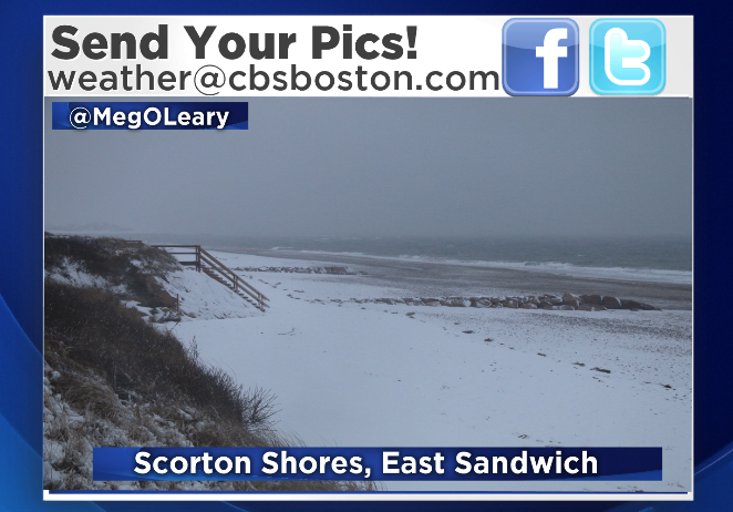
Snowy scene yet again for Cape Cod and much of SE Mass on Monday!
If you're not into the whole winter thing, you're probably already dreaming of that glorious record high we tied in Boston on Sunday. 55º already seems like a distant memory, and that marmot Phil is looking on target with his prognostication. Of course, we know that winter pretty much always extends past the start of February around these parts. In fact, February is a breeding ground for some of most infamous snowstorms (last year's blizzard, President's Day blizzard, Blizzard of '78, another in '94, yet another in '69. The list goes on! It's the perfect combo of a still cold atmosphere but an active jet stream bringing more Gulf moisture into the equation. We may be able to spin up a memorable one or two during this year's run.
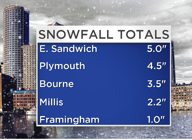
A few snow totals that came into our office this late afternoon. For a full round-up, click here.
Today's, not in the memorable category. But a dramatic shift compared to the weekend! This storm behaved pretty well around here, with a widespread 1-4" and a couple of over-achievers by an inch or so for parts of the Cape. It outperformed around NYC, dropping a daily record of 8" of snow in Central Park! Couldn't nature have sped things up by about 12 hours? Would have made for a much more exciting Superbowl, IMO. Fortunately for us locally, the mild air over the weekend combined with a lack of deep cold today made for decent travel conditions. A lot of the sloppy wet flakes melted on contact for well-traveled roads. Just be careful out there overnight, as temps falling into the 10s and 20s will create plenty of icy patches on untreated surfaces.
A nice day to catch up on clean-up is expected for Tuesday. A cold start will transition into a seasonable afternoon with highs in the 30s, lots of sun, and not too much wind. That solar radiation should help melt away some of Monday's snow, and give us a hand in clearing the sidewalks to prepare for the next blast of winter. In fact, Winter Storm Watches have already been hoisted by NWS Taunton, which will likely be upgraded to Winter Storm Warnings by Tuesday morning.
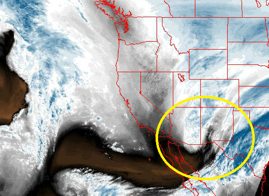
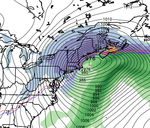
Energy responsible for our next storm, circled above, is currently digging into the southwest as a vigorous vort-max in the mid-levels of the atmosphere. Source: NOAA
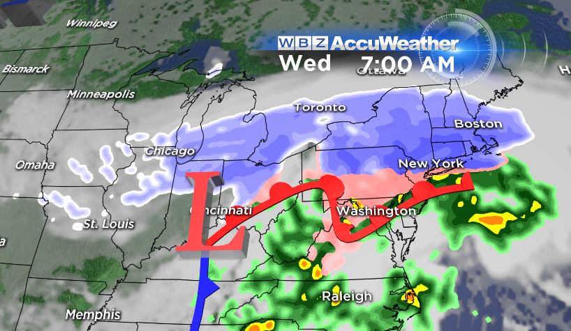
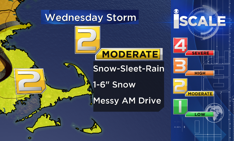
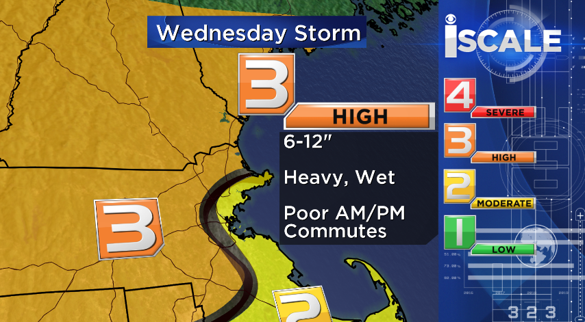
Alright, take a deep breath and let's break down Storm #2. Winter Storm Watches/Warnings/Advisories are posted in over 2 dozen states because of this little guy, who will blanket many with a widespread 5-12" of snow over the course of Tuesday and Wednesday. If you're a traveler, this will impact hubs from the southern/central Plains to the Chicago and Detroit areas, as well as NYC and Boston. For us, this all gets underway after midnight Tuesday night into Wednesday.
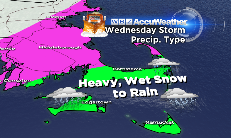
Timing And The Snow/Rain Line:
Snow should be falling for everyone after midnight Tue into Wed, increasing as we head toward daybreak. Overall, unless things change, this makes it a fairly easy call for a snow day across the area. Snow will continue into the day, not wrapping up until the late afternoon or evening. While everyone starts out as snow, this storm is quite different than the past few. The recent storms we've dealt with have all had an abundance of well below-average Arctic air to keep everyone solidly in the snow zone. But this storm will have much more marginal conditions. As Wednesday wears on, enough mild air should work northward to change the snow over to rain for much of SE Mass, especially south of Plymouth. The models keep wavering on where exactly this mix line ends up, but that's a good rough start.
Looking at most of the profiles, this storm is, for the most part, a snow or rain setup. Winds will be generally easterly which means not much of a draining cold wind coming down from the north. Those are the scenarios that give us more of a freezing rain/sleet potential. While I don't doubt there could be some icy times, they should be pretty limited in duration. Most model soundings are pointing to cold air (subfreezing) above our heads and the only real shot at above-32º near the surface.
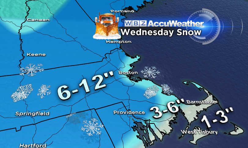
Snow Totals and Snow Type:
This storm looks a little more 'typical' for the area, with higher totals in the interior and lower totals for the Cape & Islands (finally a break for SE Mass!). Now We're still about 30 hours out, so a track farther south could keep much of SE into snow for a longer period of time, raising totals. So we'll see if anything changes through Tuesday. But for now, the mixing and sloppy nature of the snow, combined with a majority daytime event, should hold down totals there. Our snow map looks relatively generic now, and heading into Tuesday I may have to swing it to a widespread 5-10" and specifically paint in some higher total areas (like the Worcester Hills and Monadnock Region). The other thing we need to keep an eye on is banding with this storm. It's a good candidate for horizontal banding - basically a line that's mainly west to east where snow rates will be higher. If that still looks like a 'go' on Tuesday evening, we'll try to pinpoint it.
As you head northward, the snow shouldn't be quite as sloppy and more of a typical snow type. Probably wet enough for snowmen, but not wet enough to wring the water out of a snowball with your bare hands. That's much more likely near the coast and into SE Mass! This storm is also likely to set up a coastal front...a '128 Special' if you will. So right near the coast, with easterly winds bringing milder air off the ocean (surface temps are in the upper 30s right now), totals will be a bit lower and the snow should get real sloppy.
One last thing we may need to address is the CT River Valley, which may get a little bit of a 'snow shadow' effect and lower totals there. I'd definitely expect less snow from Greenfield down into Springfield than I would in Worcester County and the Berkshires.
The Bottom Line:
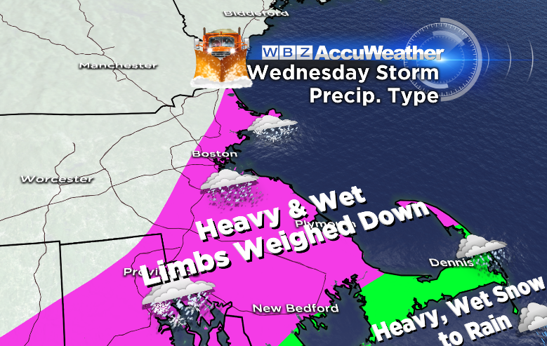
An impactful storm that, with its timing, should lead to a snow day for many and some pretty nasty shoveling. While the past several storms have been so light you can almost use a leaf blower to remove snow, this one will be much wetter and taxing on the body. Don't go too wild trying to do your 100 yard driveway in one pass. This will probably be the stuff that leads to the moniker "Heart Attack Snow." Most of the event should be over by the evening, or at the very least winding down. And for our friends along the coast - flooding is not expected to be a big issue. Minor at worst, and winds will not be as strong as the past couple storms either. Power outages will have to be monitored because of the wet nature of the snow - which may bring down some limbs and/or powerlines if conditions end up just right.
We get a break in the action to clear streets, move around snow piles, and generally brace ourselves for the next one. Thursday, Friday, and Saturday all look cold but quiet, with temps running a little bit below average and no major storminess. It's always good to get these breaks between storms to help prepare! But we may have quite a beast on our hands by Sunday.
Monday 18z GFS forecast for next Monday. Definitely a 'red flag' and a scenario that's been advertised for quite some time in the models now. Source: WeatherBell
Models have been remarkably consistent on pegging Sunday as a day for a large coastal storm along the Northeast. We started talking about it almost a week ago! No real change to that in the data. This storm would be different than the Wednesday event. It's being presented as a true Nor'easter with strong winds, lots of precipitation, coastal flooding, the works. Ironically, this comes on the weekend which is also the anniversary of last year's big Nor'easter. It's not too surprising - as we covered earlier in the blog this is prime time for snowstorms in New England.
We're still too far out for exact timing, precipitation type, and details for this one. But it most likely looks like a Sunday into Monday event, and should bring a lot of snow to parts of the Northeast. Definitely one to watch, and we'll peg the details of how this will play out as we get closer to the storm itself. At current time, the ECMWF is taking more a snowstorm track and the GFS has a more inside track bringing more of an array of weather to the area, albeit still a mainly snow/ice event. Stay tuned!