More Ups And Downs
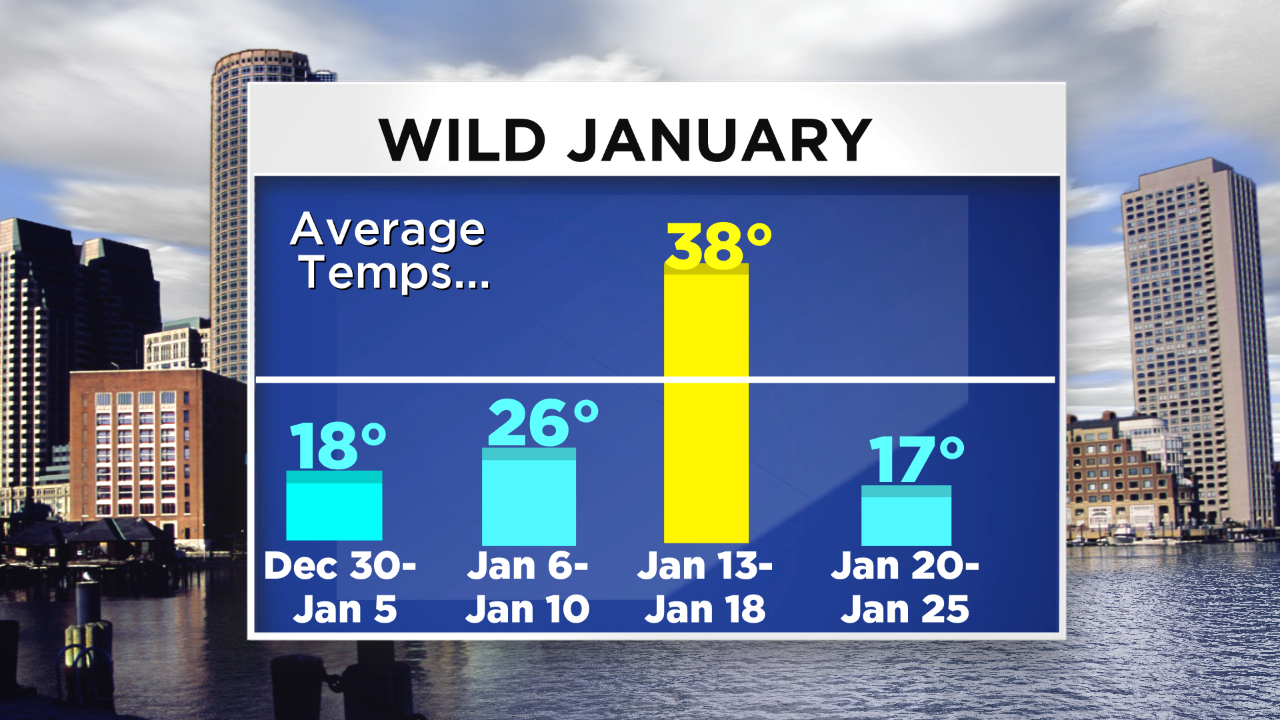 It's shocking to me that the mean temperature for this month is only 1 degree below average. Are you surprised as well? My memory is all about a focus on the repetitive attacks of arctic air. I seem to have blocked out the thaw on January 11-15 and I am thinking about the crazy spike in heating demand this winter. This is bad news for all of us because the heating bills are escalating. A tank of heating oil lasted almost 8 weeks in my home last winter and the refill coming in a few days barely makes it to 5 weeks this winter. Furthermore, we have been conserving by keeping the thermostat at 62 by day and 54 by night and I'm ok with that because I like a cool to cold house. Yet, the oil is disappearing in these attacks of frigid air despite new energy-efficient windows, great attic insulation R value and caulked and weather-stripped doors, etc. What are your thoughts on this? Last winter was not terribly cold in spite of the stormy second half and the previous winter featured incredibly warm record-breaking weather the whole time. So we're all feeling it this season big time. Thankfully, we did have those 5 days at 50 degrees or higher to give us a much-needed break.
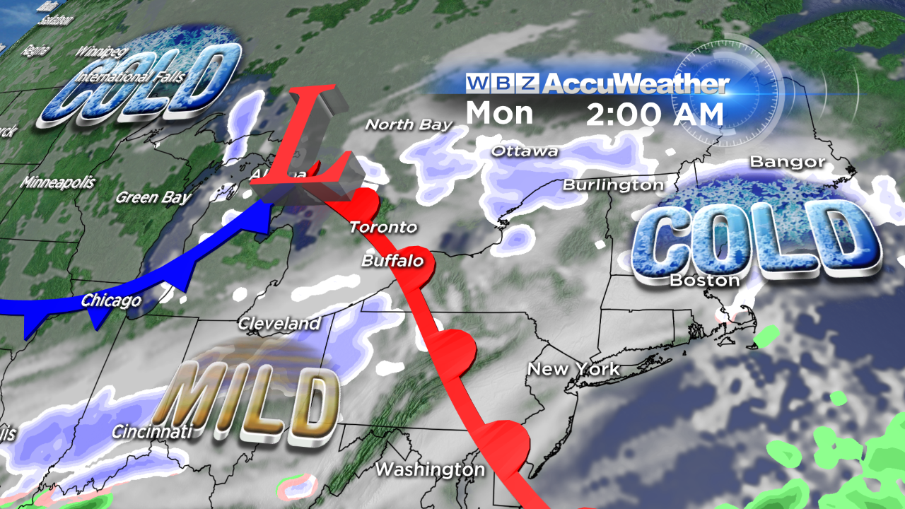 Moving ahead, there is more of the same on the way. There will be two intrusions of arctic air in this coming week. The first batch arrives late tonight and lasts for only 1 day. The second installment arrives late Monday and continues through Wednesday. As the initial parcel approaches, it is setting off a strip of snow migrating across the region early this evening. It is composed of mainly light snow but there are a few brief bursts of moderate to heavy snow embedded. Any rain should quickly turn over to snow on Cape Cod. Consequently, the roads across the region may become slippery as wet or snowy surfaces turn to some ice as the temperatures drop below 32 into the 20s. This first parcel will exit around 9pm or so as the first weak impulse and cold front move offshore. The second cold front will pass across the area in the early morning hours with the highest risk of a passing flurry or snow squall restricted to western New England. By dawn, the temperatures will be back into the middle teens to upper single numbers with windchill temperatures up to 10 below zero. Sunshine during the morning will yield to increasing afternoon cloudiness as the gusty wind becomes lighter. The maximum afternoon temperatures will be in the upper teens to lower 20s. Then, like last night, the temperatures will rise a bit after midnight tomorrow night leading to a similar warmup as today on Monday. Expect highs near 40 again before the next arctic cold front arrives during the first half of Monday afternoon. It will likely be accompanied by some rain showers which may switch briefly to snow later Monday afternoon. The frigid air will rush in Monday night so Tuesday's highs will only be in the middle to upper teens again despite bright sunshine. Following single numbers to near or slightly below zero early Wednesday morning, it will warm up to the lower 20s under a bright sunny sky.
Looking ahead, a southwesterly wind will push milder air into the Northeast next Thursday but that will not be followed by any blast of arctic air. Instead, a weather boundary may become active across the country from northern CA to the central Plains to the Ohio Valley to the Northeast. One or two storms appear to be in cue to pass through this pipeline so we may be dealing with some snow changing to rain next Friday night and Saturday depending upon the precise storm track which is indeterminate at this time.
For those of you who like to ski, snowboard, snow shoe and/or snowmobile, there are NO signs of any really big snowstorms over the next 5-7 days and that is exactly what you need! While the snow making trails are in great shape thanks to all of the very cold weather favorable for snow making, the trails that depend solely upon natural snow are thin and scratchy. Many of the glades at many of the resorts are not open due to the lack of natural snowfall this winter. Snowmobilers and nordic skiers are very disappointed. Backcountry skiing and snowboarding is extremely limited due to the snow drought. With that said, alpine skiers can find the slopes in good to fantastic shape but always be cautious for changing conditions as hardpack and icy patches appear especially on higher traffic steeper terrain. You know the drill as folks hit the brakes and plow off the snow to the sides making icy stretches. Morning skiing is always best following the overnight grooming. Please be courteous and in control on the trails!
Danielle Niles posts her thoughts tomorrow morning and I shall return in the afternoon.
Enjoy the last Sunday of January.


