Friday Flakes, Then Milder Times Ahead
Find Eric Fisher on Twitter and Facebook
It's a slow but steady climb out of the basement so far as our temperatures are concerned. Many towns hit 30 on Thursday...and that was a warm-up! But we're making progress, with a significant break from the chill on the way for the weekend and into next week. Just have to get through a 'typical' January day on Friday before that happens!
For skywatchers - there's a chance the Northern Lights are in play Thursday night into Friday morning. The CME from Tuesday's X-Class flare struck the Earth around 3pm EST today, but in reached us in a weaker state than expected. Space weather forecasts are sticking to their 'G3' level storm...but chances are that it may be the higher latitudes that end up with a show. Be that as it may, your best bet is to be away from city lights and to look low on the horizon toward the north overnight. The best window will be before midnight, as high cloudiness will start to fuzz up the sky beyond that. Hopefully at least some folks in VT/NH/ME get a show!
The producer of those clouds is a quick-moving but vigorous little short-wave, which will pass across New England on Friday. There's enough lift and moisture with this one to create a general area of snow showers, which may slicken up the roads a bit on Friday morning. Temperatures will be cold enough for snowflakes to stick. Rates aren't expected to be high, nor will amounts (a Trace to an inch or so)...but be careful out there on the streets. Enough warming in the lower levels of the atmosphere should change scattered flakes to raindrops instead after lunchtime, especially south of the Pike. In general, expect a gray and damp Friday with highs eventually reaching the low/mid 30s during the 2nd half of the day.
The 'real deal' warm-up is for this weekend. On Saturday morning we'll have to keep an eye out for potential freezing rain, especially for NW Mass and VT/NH. Most of the area should be warm enough to keep that from happening, though. Scattered rain showers during the morning and midday on Saturday will give way to a higher chance of steady and heavy rain by the evening. The storm center will be passing well to our west, allowing for a deep pull of southerly winds to flow up across New England. So much warm air will be involved that rain is expected all the way across most of the mountains to the north...not great news for ski areas. There will be strong forcing along the cold front with this one, and PWATs (precipitable water) way above average for this time of the year...about +3SDs. So evening rain could be quite heavy with perhaps even a clap of thunder. Just about everyone should see between 1-2" for the day, and ice jam flooding may be a problem as chunks that froze up during recent bitter cold will be melting, plus the additional heavy rain.
Gillette Stadium should look a lot like it did when Buffalo came to town a couple weeks ago, just with temps 15 degrees warmer. Definitely not a very cold rain, with temps in the 50s to near 60! The potential is also there for some big wind gusts, however a strong inversion near the surface may hold that potential down some. I'd say we're in for at least 20-40mph gusts, with perhaps some to 50 if low-top convection can develop and mix some of the stronger winds down. Mild and wild will be the rule!
The storm is progressive, so most, if not all, of the rain should be gone by early Sunday morning. There isn't any real cold air in its wake, so temperatures should hover in the 40s to near 50 all day on Sunday. A very gusty west wind should make it feel chillier, but the second half of the weekend looks dry with above average temperatures.
If there was any one day to pick as a gem, I'd go with Monday right now. Models are hinting at limited mixing...which may keep us from the real big warmth. But 850mb temps are up around +8 and we should see plenty of sunshine. Considering there won't be any snow on the ground and we'll have a consistent SW wind...I'd wager at least the low 50s. If somehow the models are wrong on the mixing depth and we can reach up a little farther...we could have a shot at 60! This looks like a long shot for now but we'll see if that changes as we get closer. In any case, a fine day.
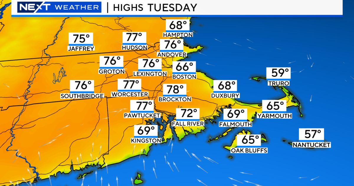
Up next on our storm menu is another rain event on Tuesday. The ECMWF is milder on this one, while the GFS is more progressive and chillier. I'm leaning on the mild side for now with highs in the 50s, but check back in for updates if this scenario changes. Colder air will move in to end next week, back toward what's typical for mid-January.