HAPPY NEW YEAR!
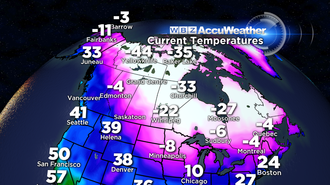 Some harsh winter weather is impending as we get ready to ring in 2014. Bundles of energy are gyrating along in the jet stream so the atmosphere is primed to produce snow followed by a blast of frigid weather. For days and even several weeks, I have been harping on the magnitude of arctic chill in the air masses moving across Canada. There have been several invasions of bitterly cold air into portions of the our nation. International Falls, MN has experienced one of its coldest Decembers ever on record with the mean temperature an astonishing 13.4 degrees below average. That is insane! Its morning minimum today was about 30 degrees below zero! This is worrisome because the undulating steering currents are favorable for delivering some crazy cold to New England in the next week. Fortunately, it will not match the sting of the upper Mississippi Valley and Great Lakes but it will be numbing for sure. In fact, Boston could be near or slightly below zero Saturday morning ranging down to at least 15 to 30 degrees below zero across northern New England! It will not bottom out like it did on December 29, 1933 when Boston had its second lowest temperature on record going back over 140 years. BTW, the city's coldest day was about two months later on February 18, 1934.
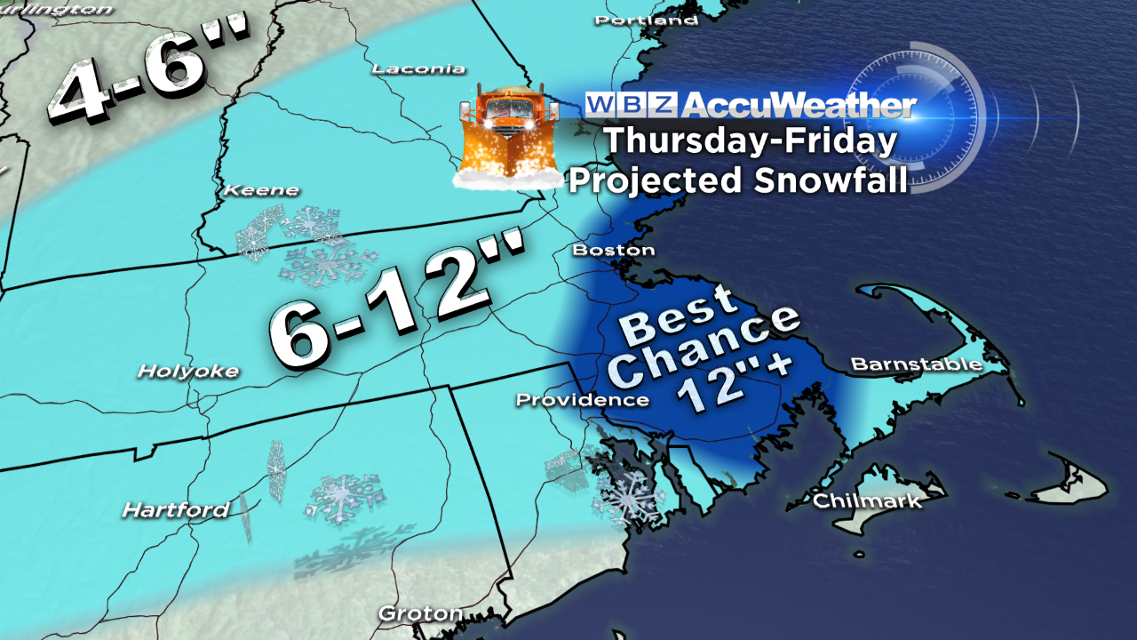 One cold front is passing is passing through on this New Year's Eve and there have been a few isolated flurries associated with it. A bubble of high pressure will build across Quebec tomorrow as another cold front settles into northern New England. There will be some sunshine yielding to varying amounts of cloudiness in the afternoon. The boundary dropping into the region will provide an axis for light snow to break out late tomorrow night so there could be a dusting to an inch on the ground in many locations by 7am Thursday. During that day, the snow will be occasional and mostly light so I am projecting another 1-3" during the day with the heaviest snowfall to occur Thursday evening to just prior to dawn on Friday. The amount of snow of snow during that time frame is dependent upon a couple of factors. There will be two waves of low pressure passing out south of New England. My forecast of 6-12" falling Thursday night is a function of the precipitation field flaring deeply into New England. Additionally, as the arctic air is drawn southward from Canada, the density of the snow will decrease sharply so it should turn into a real fluff job with a rain/snow ratio of 1:20 so if that verifies, I believe that there is a reasonably decent shot at some areas getting more than a foot and possibly up to 18" in favorable ocean-enhanced corridors on the South Shore and North Shore despite the fact that a large volume of precipitable water is not available from this storm. It is a straight shot of snow with no mixing except on the outer Cape and Islands in this cold arctic environment as the wind backs from northeast to north-northeast to northerly. As the pressure gradient tightens, wind speeds of 25-50 mph are quite likely and that will produce much blowing and drifting snow later Thursday night through Friday morning. The wind will crank up the seas coincident with the highest tides of the month. Consequently, there is potential for minor to moderate coastal flooding an hour or two either side of the midnight high tide Thursday night. The highest scheduled tides due to astronomical conditions occur a just before noon on Thursday and just after noon on Friday. The Thursday morning tide should not be an issue but the Friday morning tide may still produce some minor with pockets of moderate flooding. By then, the wind will be blowing more offshore. Temperatures could be falling through the teens into the single numbers north and west of Boston Thursday night and Friday morning! Unlike the preceding storm that released 1 to 1.5" of rain last Sunday, this system will not be tapping as much moisture from the Gulf of Mexico. What is gathered will mostly stream out to sea with the first wave of low pressure. We are counting on the second wave from the Ohio and Tennessee Valley to be the catalyst for the bulk of the snowfall.
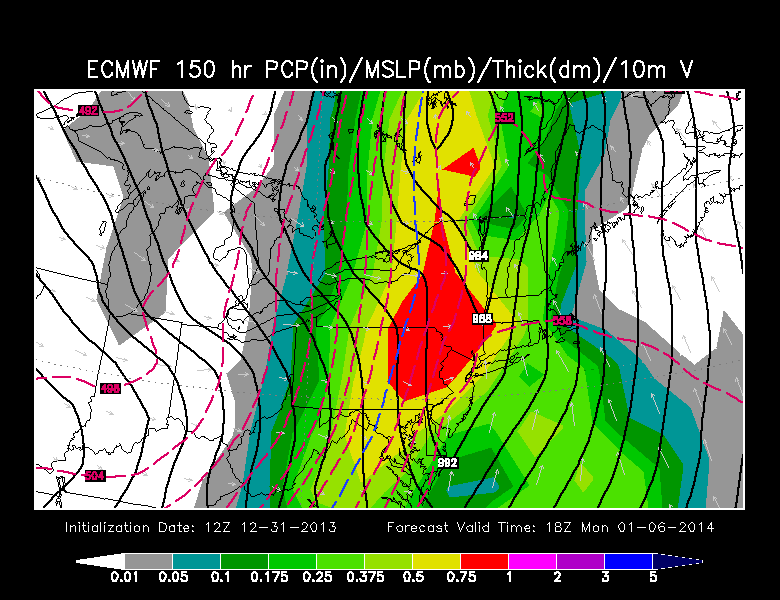 Looking ahead, there is a conflict of guidance regarding a potential storm later Sunday and Monday. The more reliable model is sharply amplifying the upper air pattern which would drive the surface storm well west of New England causing showery rains. This track would yank some very warm air up the eastern seaboard to support temperatures well into the 50s! The wind would be ferocious and damaging and shifting from southeast to south to westerly with a dramatic temperature plunge late Monday afternoon and evening. It could be wild if this storm track verifies. This model has been displaying persistence on multiple runs so this solution cannot be ignored. On the other hand, other guidance is steadfast on a much closer storm path into New England with much less intensity and that would be a more desirable outcome because the wind would not be so threatening. In any event, we need to wait until Saturday for a more highly confident prediction.
Danielle Niles will be posting her thoughts tomorrow morning and Eric Fisher will follow later in the day.
HAPPY NEW YEAR!