Busy Weatherbees Ahead!
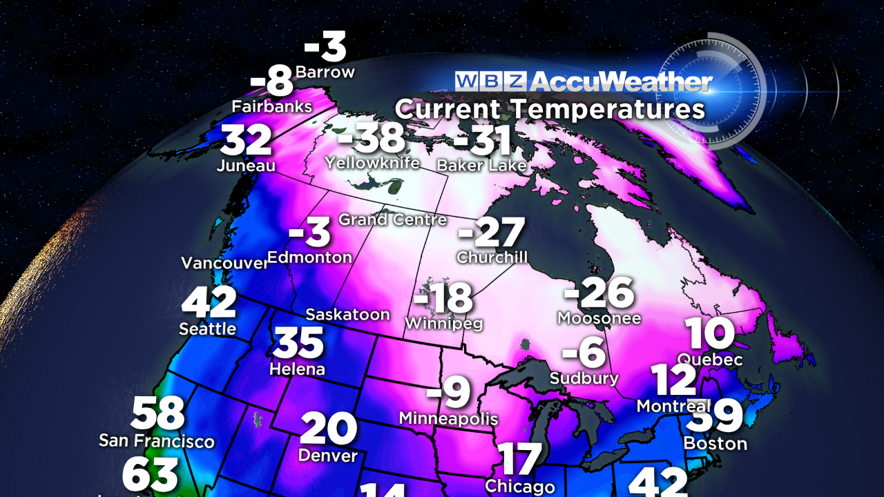 Following an autumn of peaceful weather overall, us forecasters will be busy bees over the next two weeks following lots of weather changes across North America. The jet stream is becoming supercharged with parcels of energy in a state of flux so troughs of low pressure will be undulating and gyrating across the continent in varying amplitudes. We are definitely dealing with a fluid atmosphere and the changes will be fast and possibly furious. While last January was benign, this one could be just the reverse. With that said, I am presently not postulating with any confidence that major storms are positively in the making. Rather, we must remain vigilant for forecast revisions now and then. I reiterate that the presence of super arctic air expanding across Canada is worrisome because slight directional shifts of wind aloft can suddenly propel a blast of arctic chill into at least the northern portion of our country including the Northeast. One such chunk is plunging into the upper Mississippi Valley right now with the current temperature of 7 degrees below zero at Minneapolis, MN! In the next couple of weeks at least, there are indications that several chunks of even colder subzero air will dive into the nation striking the north central portion of the country first. One model has been advertising one of the cores of frigid air to contain air as much as 50 degrees below the average for the Midwest! That is astonishing and disturbing because of the danger of such extreme cold not to mention that heating costs will obviously soar. Despite last winter's major blizzard, we have been living a charmed life for the most part over the past few winters as far as cold air is concerned. Blasts of arctic air have been brief and few and far between especially here in southern New England. I am not suggesting that the whole month of January will feature numbing cold. Instead, I feel that some wild fluctuations in temperature are quite possible but the month overall is destined to have a mean temperature below to possibly much below average. Last January's mean temperature was 2.5 degrees above average and January 2012 was a whopping 5.2 degrees above average. With the cyclical nature of weather, we are due for a colder than average January and current global factors support that.
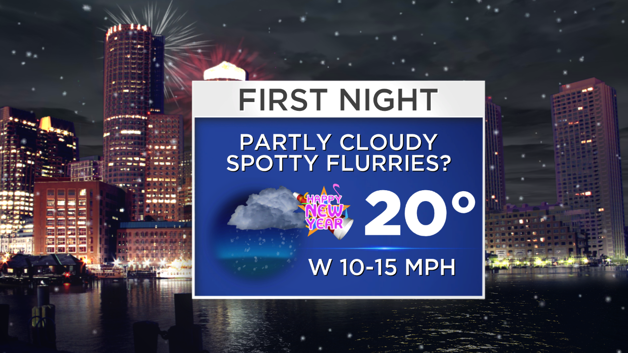 Back to the immediate future, we are dealing with an envelope of moderate to heavy rain which is racing out of the region. As advertised, the heaviest rain was coincident with the Pats/Bills Game and the rain will become lighter and more showery as the evening progresses. Meantime, a transition to big wet snowflakes is unfolding over northern New England where a strip of several inches of snow will accumulate from central VT across central NH into much of central and southern ME. A few sloppy inches could build up over portions of southern VT, southern NH and far northwestern MA. A coating up to an inch is possible over north central MA in the hillier terrain. The storm creating this mess will cross Cape Cod producing a brief warmup to the lower 50s and a spell of gusty southeast to southerly winds of 20-45 mph there. Snow and rain will be long gone by dawn so roads should be in decent shape for traveling at that time. A cold frontal passage will follow around midday tomorrow so the sky will contain a changeable amount of clouds between the bursts of sunshine. It will be in the lower to middle 30s through midday then fall into the upper to middle 20s later in the afternoon especially north and west of Boston. The last day of 2013 will be colder with highs in the middle 20s. The next disturbance will be approaching from the west so bright sunshine early in the day will yield to much cloudiness and some snow showers from the afternoon into New Year's Eve. There is little support for this feature to develop and it is starved for moisture. Temperatures will fall into the range of 15-20 degrees for First Night with a cold breeze at times but no blustery conditions are anticipated.
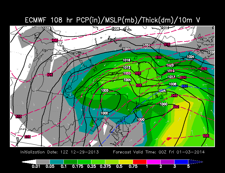 The next system will be attempting to organize in the Midwest and Ohio Valley and a strip of snow flurries may stream eastward into New England by late in the day on Wednesday, January 1, 2014. As this weak low pressure system meanders across PA, there should be an energy transfer to a new center forming on the coast and gathering moisture. Presently, it appears that the approaching upper level support is not powering up substantially until the surface storm is moving offshore. Consequently, at this early stage, it is impossible for anyone to be confident of how this all shakes out 4 days in advance. Could it get its act together and nail us? Yes. Could it simply brush us with light snow? Yes. Both of these solutions are plausible given the various parameters now. Due to the presence of arctic air seeping into the region from Canada, there will be a fluff factor to consider. So even though the models are not generating a large volume of precipitation due to weak atmospheric lifting, the low density snowfall totals will be enhanced as a rain/snow ratio of up to 1:20 is possible. Preliminarily, based upon the given cast of variables, I will make a stab that 10 or so inches of fluffy snow is the most reasonable forecast for parts of the area. The probability of a wetter snow and even a potpourri of precipitation over Cape Cod and the South Coast is relatively high. The duration of snow will be drawn out into Friday morning. Current guidance suggests the heaviest snow will fall Thursday afternoon and evening but lighter snow may linger through Friday morning with much blowing and drifting as strong winds occur on the back side of the deepening storm offshore. Keep in mind this scenario is based upon present modeling. With the atmosphere constantly in motion, new data may warrant a different solution. It will be interesting to watch how the model output zigs and zags as we approach the actual event. Forecast confidence should heighten by late Tuesday. One aspect that is quite clear right now is that a blast of arctic air will arrive Friday and last into early Saturday sucked in by the departing storm. After that, a surge of much milder air is on tap for next Sunday.
Todd Gutner posts his thought tomorrow morning and Eric Fisher follows later in the day.
Enjoy the final two days of 2013.