Flakes Then Frigid
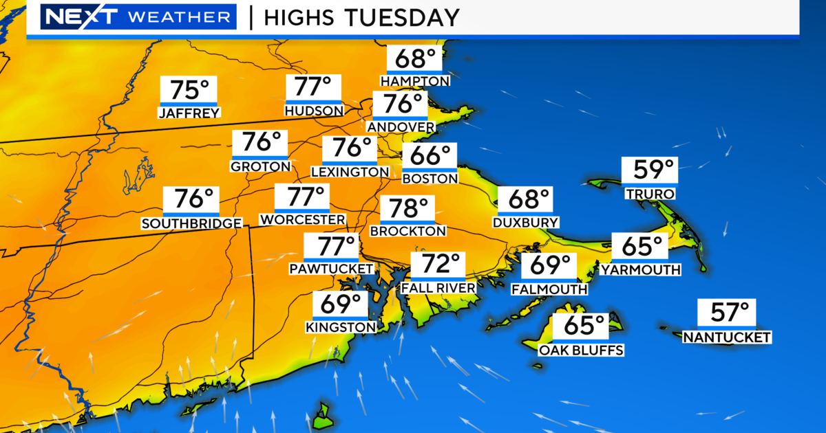
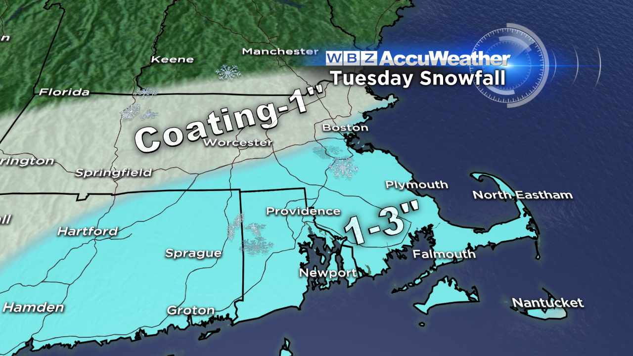 There has been a series of low impact storms over the past week or so. Today's system released a coating up to 2" of snow followed by sleet, freezing rain then rain then mist and fog. The damp conditions will give way to some drying overnight as temperatures coast back below 32 degrees north and west of Boston. Keep in mind that some icy patches are probable later on. The next wave of low pressure will zoom northeastward from the lower Mississippi Valley with the center passing well south of New England. The northern fringe of the steadier light snow will stream up over southern New England tomorrow. Extrapolation brings the flakes into the Worcester-Boston area around 8-10 am so it appears that it should not impact much of the AM commute. On the other end, most of the snow should be exiting before the rush of the PM commute begins. I am expecting nothing more than a coating up to an inch north of the MA Pike with only flurries possible over parts of northern New England. Meantime, more than an inch and possibly up to 2-3" is the reasonable projection south of the MA Pike with less on the immediate South Coast and the outer Cape Cod area. Temperatures will not rise much tomorrow with highs in the lower 30s except middle 30s on the Cape. The system will depart creating clearing from northwest to southeast from late afternoon into the evening. It will drop to the upper teens to lower 20s tomorrow night.
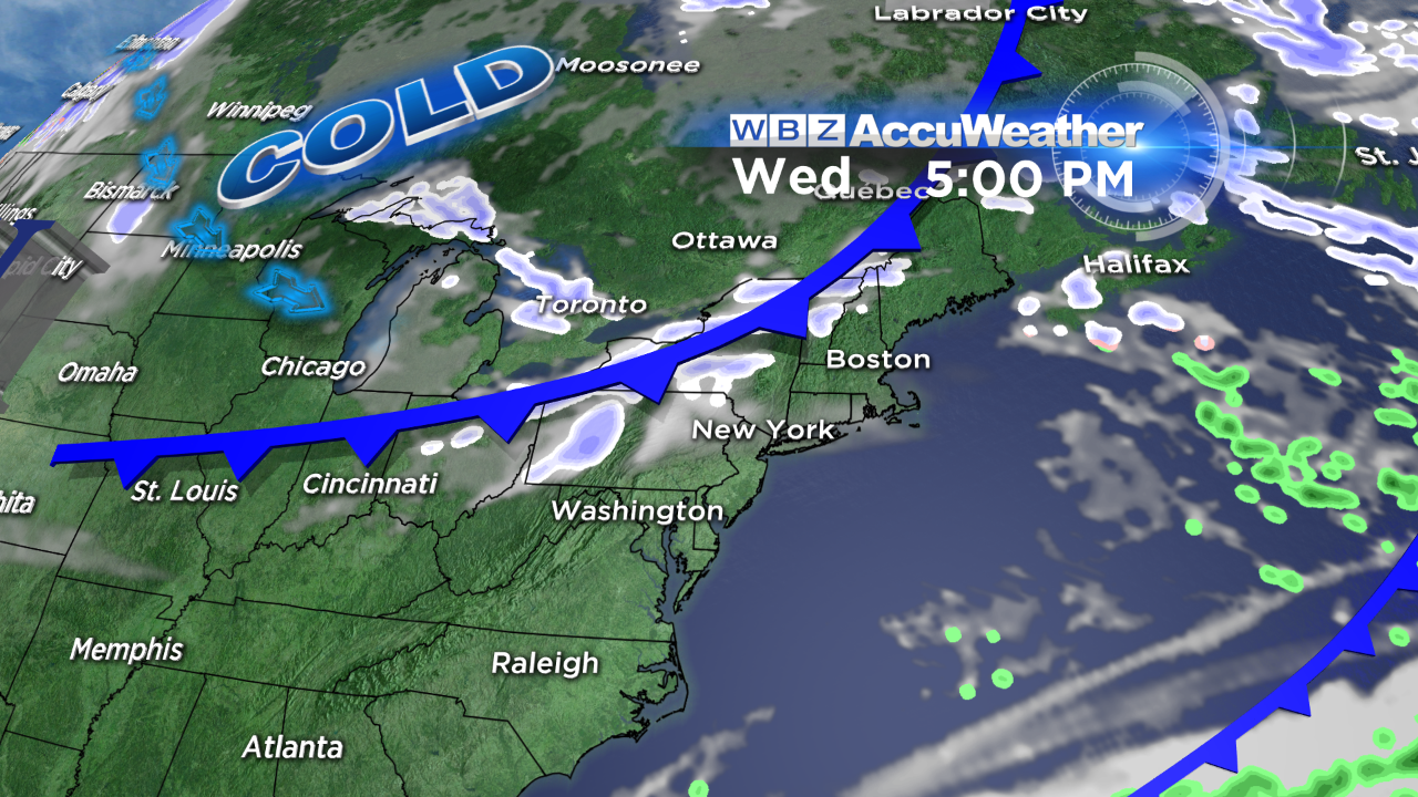 Wednesday will start sunny but varying amounts of passing clouds are likely by late morning through the afternoon. Some of these clouds will drop spotty flurries as an arctic cold front drops into the region from the northwest. Following the frontal passage, very cold air will be flowing in from Canada and the Great Lakes. I wouldn't be surprised if the temperatures didn't reach 20 degrees from northwestern Middlesex County and Worcester County north and west. Boston's expected high of 23 will be about 20 degrees below the average! Arctic air will continue to keep us shivering with lows of 5-15 degrees Friday morning and highs that afternoon in the middle 20s.
Looking ahead, the next weather maker will be a storm of greater magnitude on Saturday. It will certainly be sufficiently cold to support snow at the onset in the morning followed by a switch to sleet and freezing rain then rain from south to north across southern and central New England. Current indications point to a few to several inches of snow across portions of northern MA before ice and rain takes over. The northern ski resorts may receive 6 up to perhaps 12 inches of snow! This storm has much more energy to work with so heavier precipitation is anticipated. The storm will exit Saturday night with partly sunny and breezy weather with highs in the lower 40s on Sunday. Another arctic front will pass through next Sunday night leading to colder air again on Monday.
Wednesday marks the 5th anniversary of the beginning of a record-breaking ice storm which produced widespread tree damage and power outages across northern MA into northern New England. Some places had no electricity up to 6-12 days!!
Todd Gutner posts his thoughts in the morning.
Make it a great Tuesday!