Another Beauty Wednesday, Then Rain Returns
Find Eric Fisher on Twitter and Facebook
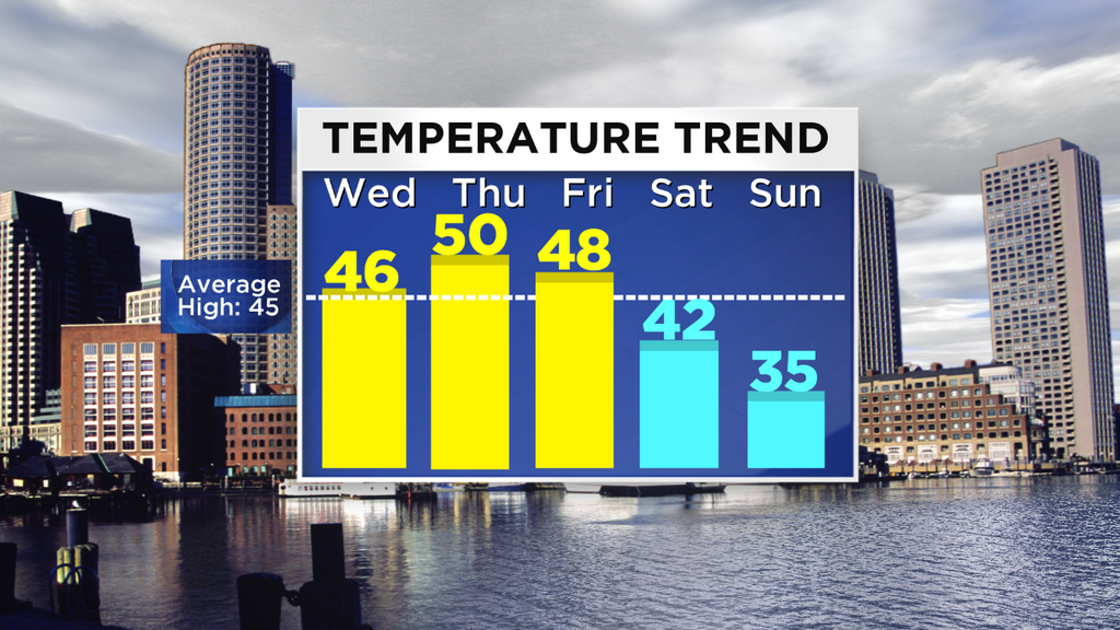
I'm not proud of it, but my standards are lower this time of year. Funny how that works...when all of the sudden mid 40s feel like a bonus day in December (it really wasn't, the average high for this date is 46º). But with sunshine and in the absence of much wind, it felt 100% fine out there. We'll do it again on Wednesday, so I'll be short on the quiet details for the next 24 hours. An ocean storm will move farther out to sea and take away the clouds that have been hanging tough for the Outer Cape & Nantucket. Mainly clear tonight with temps in the mid 20s to mid 30s, and mostly sunny/comfortable tomorrow with highs generally in the mid 40s.
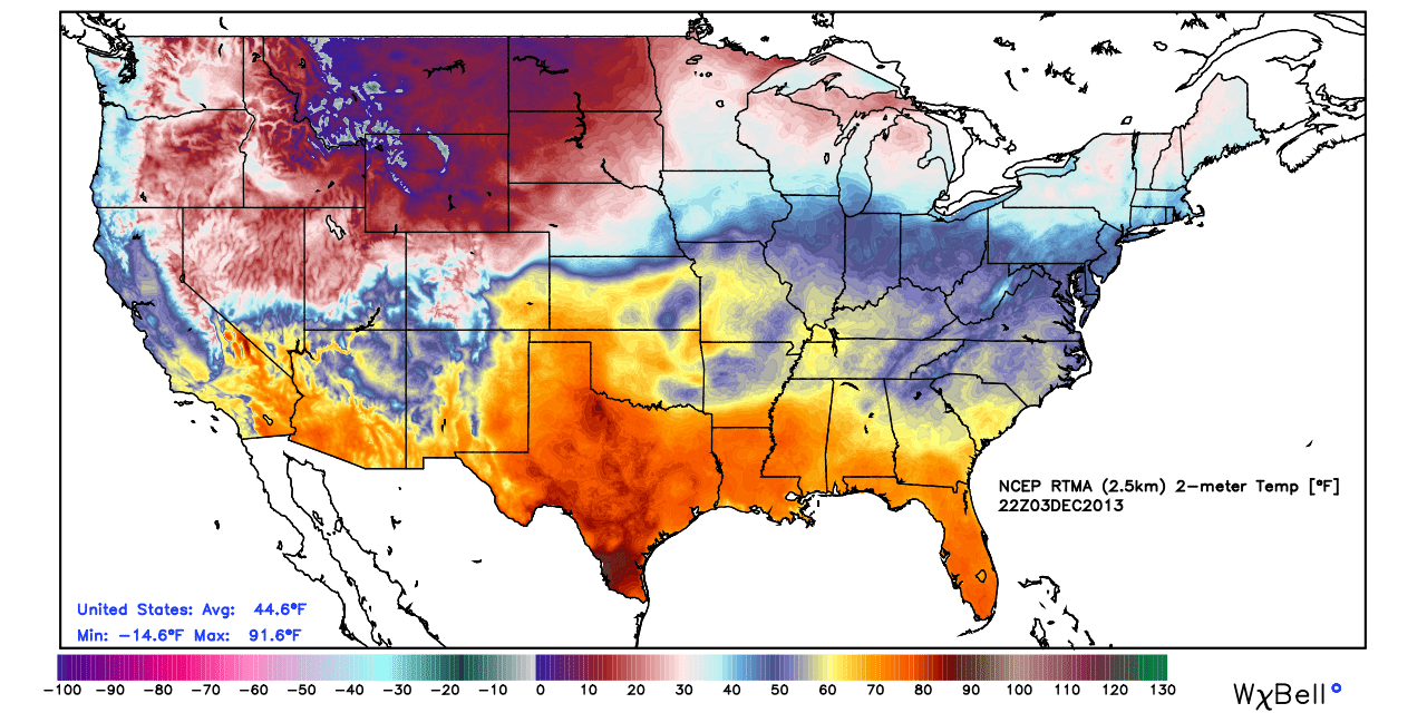
A major Arctic Outbreak has begun! Look at the widespread -10 to 15ºF temperatures moving in across the NW. Bitterly cold air will slowly ooze across nearly the entire Lower 48 this week.
Once we head into Wednesday night, a much more active pattern will kick off. All of it is being caused by a massive Arctic Outbreak in the west, which, when forced up against mild air here, will provide a neat and tidy storm track that will linger into the weekend. The first impulse arrives as a warm front on Thursday, which will bring mostly cloudy skies and areas of showers/drizzle. That being said, I doubt anyone will mind too much. No real heavy rain is currently expected, and temperatures will be mild - climbing into the low 50s for many spots. Almost a spring-like feel.
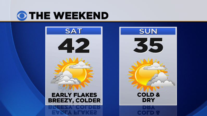
For Thursday night and Friday, a more potent disturbance will ride up along that front and into New England. Temperatures locally should end up being too warm for icy concerns, with highs on Friday again near 50. While there are a few timing/strength differences in the computer models, the general idea is the same. We'll see a couple waves of rain & showers Thursday night through Saturday morning with a majority of overcast skies and a damp feel to the air. As cold air blows in from the north on Saturday morning, we may be able to briefly change that rain over to snowfall. This far out, I'd say the best shot of seeing this happen will be in the Worcester Hills, perhaps even coating the ground nicely to start the weekend. But we'll work out the exact timing/amounts on that as we get closer.
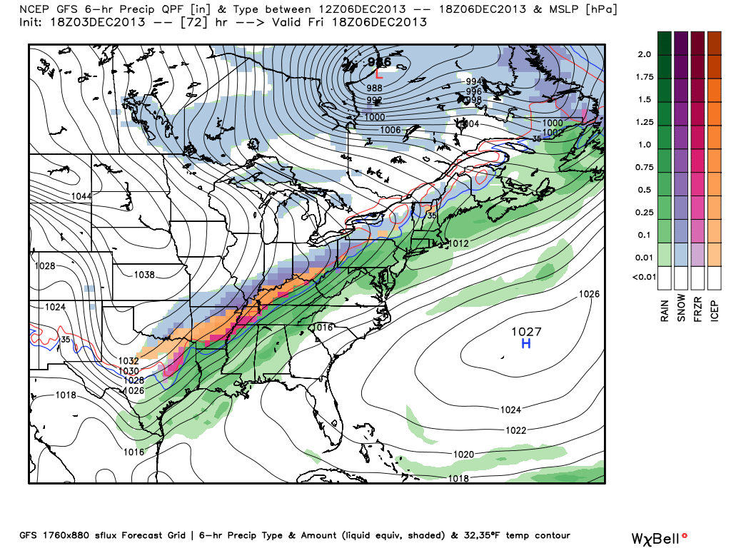
A look at the GFS forecast for Friday (Courtesy WeatherBell). Shows the battleground lining up from Maine to Texas. We'll be on the mild side of this lie for most of the event, but you can see all the icy mess expected from Dallas to Cleveland on the cold side!
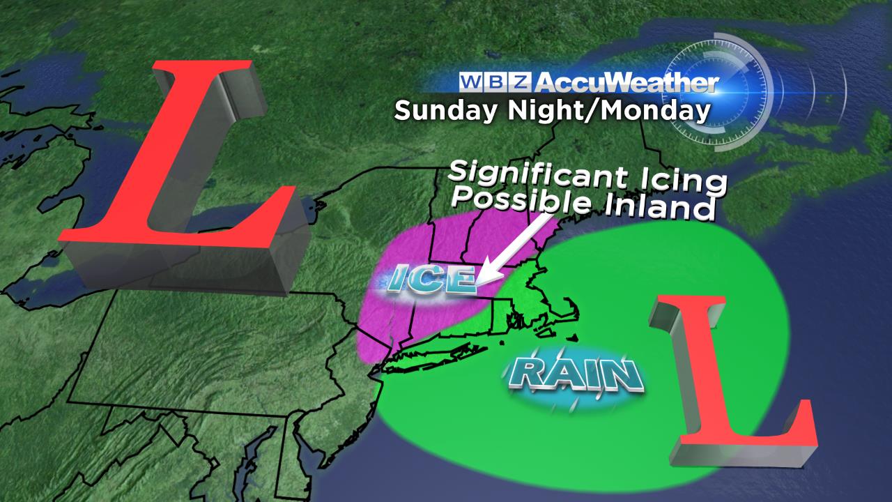
The idea for the weekend is that we'll set the stage for a potentially more significant event Sunday night into Monday. Drier and colder air will work down on Saturday, and most of the day looks dry. Sunday looks cold and quiet as well, with highs a good 10º below average. At this point our eyes turn to yet another storm gathering strength near the Gulf Coast. But there's something different about this one...an area of high pressure that will be centered in SE Canada. This is an excellent setup for icing, perhaps as far south as the Carolinas.
Seeing as it's 5 days out, there is still plenty that can change. But a high pressure area in that location during the winter can produce 'cold air damming.' In this instance, the 'dam' is the Appalachian mountains. Cold air underneath the high snakes its way down the East Coast, and runs up into the mountains. There it lies, until warmer air can blow in and dislodge it. But typically, if the high is strong/stationary, warm air doesn't push out the denser, cold air and the rain freezes as it falls toward the surface, giving you either freezing rain or sleet.
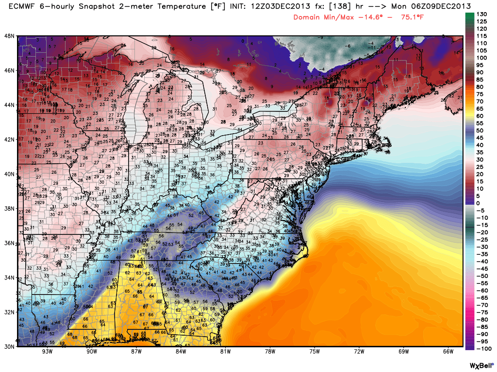
On this ECMWF forecast for Sunday night (courtesy WeatherBell) you can see the Cold Air Damming signature. A tongue of cold air that runs down the eastern slopes of the Appalachains and dips all the way down into northern Georgia.
I'm still slightly skeptical at the breadth of this icing event in our area for a couple of reasons. One being that the high slides east in some of the models by the time the precipitation is moving in here. That would mean a more SE wind flow than a NE wind flow, and more mild air invading. The other thing to watch for will be the timing of the precipitation moving in. If temps can fall back more Sunday night before wintry mix moves in, that would increase the odds of ice for us. But if it speeds up and comes in during the day, that task may be more difficult. And finally, the dewpoints during the onset are important, because evaporational cooling could help drop many towns down a few degrees (they're expected to be in the 0s/10s to start). In any case, I'm not too worried about much ice for coastal zones because the wind will be off the Atlantic, which is about 46º right now. Any significant icing would likely be held to interior sections of New England.
Yet another impulse will move up the coast on Tuesday! That means more rain, which may end as snow before moving out. So plenty to keep a close eye on in the extended forecast, that's for sure. And our very dry autumn has given way to what nature almost always does - an effort to balance. More storms to help make up for a hefty rainfall deficit August-October.
Last note - a big thank you to Cashman Elementary School in Amesbury for having me come jabber on about the weather. We brought the Mobile Accuweather Lab up (the kids seemed to like this the best) and took a few great questions from the huge group of 550 students in the gymnasium. Here's a video of all those smiling faces...I gotta say - some of the best behaved kids I've ever seen!


