Cold But Quiet
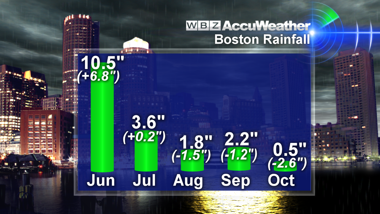 The region needs a big rain storm to squelch the very dry conditions. Following a monsoonal June with more than 10" of rain and near average rainfall in July, we have had 3 dry months. October will enter the record books as extremely dry with a deficit of more than 3 inches yielding a shortage of almost 5" for the 3-month period. It appears that the weather pattern will remain peaceful for many days to come perhaps lasting through Halloween. There will only be a couple of cold frontal passages in the next 7 days and these boundaries are starved for moisture as they race out of Canada. Eventually, some beneficial rainfall will arrive and that may happen next weekend on Saturday just prior to the ending of Daylight Saving Time at 2 am on November 3rd. The clocks will reverse 1 hour and the sunset on that Sunday will be 4:35 pm. UGH!!
 For much of October, the temperatures have been above average and the mean temperature for the month is more than 4 degrees above the average. However, a change in the steering currents ushered in colder than average weather on Wednesday and this morning was the coldest for most locations since late April. The temperature bottomed out at 39 degrees in Boston which is the first time it has gone below 40 since April 22nd when it was 36. It was exactly 40 degrees on May 5 and 41 on May 26. A recovery to near or slightly over 50 is predicted for today and that is more than a half-dozen degrees below the average for October 25. As a ridge of high pressure builds to the south of the Northeast, a resultant busy southwesterly wind will produce a warm-up over the weekend with highs closer to the average of 58. That will follow another chilly night ahead with the lowlands back into the 20s to lower 30s. Today's sky will feature plentiful sunshine through mid-morning then patches of passing clouds will occasionally interrupt the sunshine from late morning into the afternoon hours. Cloudiness will be variable over western and northern New England tomorrow as a weak warm frontal boundary passes through. A cold front will also be approaching from the Great Lakes area and that will spill added clouds across the region Saturday night to early Sunday when a brief mostly light shower or sprinkle is possible in only a few spots. Despite the passage of the cold front Sunday morning, it will still be nice on Sunday with sunshine and just a few clouds and less wind than tomorrow. It should be just fine as the Patriots host the Dolphins for a 1 pm game at Gillette Stadium.
 Looking ahead, the next wimpy cold front will settle southward into the region late Monday into Tuesday. It will generate varying amounts of clouds with minimal support for an isolated shower or widely scattered sprinkles. The next ridge of high pressure is slated to build in on Wednesday with colder weather back into the lower 50s. With the assumption that this zone of high pressure will build south of New England, milder weather should return on Halloween with highs closer to 60 and no rain. If the high pressure system hangs up to the north, a frontal boundary could develop into the region and some showers may materialize for the ghosts and goblins. At this time, I am not buying into that solution so I'll cautiously forecast decent conditions for trick or treat time with no cancellation due to snow or a tropical storm this year thankfully. Long range guidance indicates a surge of warm and windy weather with some rain later next Friday and Saturday.
Eric Fisher will post his blog this evening and I shall be on duty all day tomorrow.
Have a happy and safe weekend.