Roller Coaster Ride
 You'll remember the next few days by the dramatic fluctuating temperatures. The roller coaster ride actually commenced yesterday when it warmed up an average of 35 degrees from the morning mins! While today's range will be meager, get ready for some massive moves this week. Expect a plunge to the 40s tonight followed by lower 90s on Wednesday afternoon! These yo-yo temperatures are more fascinating and exciting to me than severe thunderstorms, tornadoes and hurricanes. Destructive storms cause hardship, pain, injuries and even fatalities. I can't imagine anyone wishing for such evil events. Thankfully, despite a few wild twisters, the tornado count is much lower than average and there hasn't been a single hurricane this season. Just think how great that really is. Weather is cyclical so I imagine that we will pay for this long quiet period in the years ahead. For now, we can rejoice and be enormously grateful for ho-hum weather.
A cold frontal boundary is surging southward across northern New England early this morning. Well in advance of the front, a couple streaks of mostly light showers zipped across MA early this morning around 2-4 am. Associated with the front, another batch of somewhat heavier rain briefly struck the northern mountains just after dawn. As the front approaches the Boston area at midday, there is little remaining support to spark any meaningful new showers. As a result, there would only be a broken band of clouds passing through with an outside shot at a brief sprinkle. Therefore, the sky will be changeable from sunshine to clouds and back to sunshine as the boundary clips along. It will push off Cape Cod by 3-4 pm. That opens the door for a sizeable zone of high pressure to build in from the Great Lakes to the Northeast overnight. The gusty wind which will ramp up to 15-30 mph this afternoon will diminish swiftly this evening.
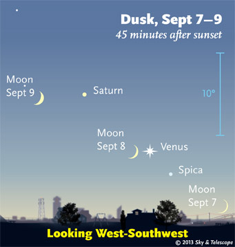 Following the lower to middle 70s this afternoon, we will be able to see a celestial event of the pairing of the waxing crescent moon and bright planet Venus thanks to a clear sky. Look to the western sky about 30 minutes or so after sunset. Temperatures will be tumbling down through the 50s this evening to the 40s after midnight. Sunshine will be bright tomorrow morning then become filtered as the afternoon progresses by the arrival of some high cloudiness. The wind will be light to start then begin blowing in from the east to southeast at the coast as the morning goes on with s shift to more southerly at 6-12 mph in the afternoon. Again, it will warm up almost 30 degrees from the morning mins. Less cooling is in store tomorrow night as a warm frontal boundary closes in from the west. It could deliver a few scattered showers Tuesday morning into the afternoon. With its passage in the afternoon, some sunshine could break out to initiate some decent warming to near 80 degrees by 5-6 pm.
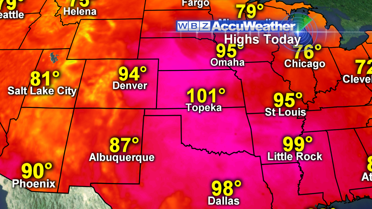 Looking ahead, the heat currently baking the Plains States will be surging eastward as the jetstream shifts and propels the sweltering stuff into the Northeast. Remarkable warming aloft suggest potential surface temperatures reaching and exceeding 90 in most areas away from south-facing coastal locations. Presently, I am predicting a high of 92 in Boston which is the first 90-degree reading since the 96 on July 20 at the conclusion of a 7-day heat wave. There simply were no days a 90 or higher in August which happened only 5 years previously in 2008. In Boston, on average, August produces 3 days over 90 degrees with 1 day in September. It now looks like we'll get that one day on 9-11! This prediction is based upon the expectation of realizing decent sunshine and patches of clouds with most of the showers and storms erupting across portions of the northern mountains. The cold front will gradually sag southeastward across NY and New England on Thursday with dynamics available for developing convection. Some of the storms may be strong to severe but that is dependent upon the amount of available sunshine in the morning. Lots of early cloudiness will lead to less squally weather. Perhaps the clouds will come to the rescue and diminish the threat. We shall see. Once the front shifts just offshore, the wind will become northeasterly and varying amounts to considerable amounts of clouds may rule the sky next Friday and Saturday. A possible upper level trough deepening into the Northeast could cause some showers especially over southeastern MA and Cape Cod. Once the trough exits early Sunday, it will become sunnier and more pleasant a week from today. With that said, next weekend's forecast is not one of high confidence at this composing time.
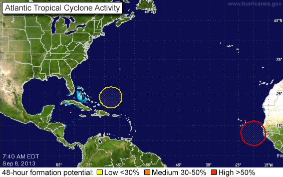 Checking the tropics, there is one disturbance just west of the African coast that has a 90% chance of developing into a tropical cyclone within 5 days. According to the National Hurricane Center, conditions are becoming more favorable way out there as it chugs closer to the Cape Verde Islands in the days ahead.
Joe Joyce will post his blog early this evening and Todd Gutner is on duty early tomorrow morning.
Make it a great week!