I'll Take Another
It just doesn't get any better than this in early May. In many past years, there has been a leap from winter right to summer without any delightful spring weather in between to enjoy. That is not the case this year. It has been so beautiful lately and I had a dream it was like this for a whole summer. WOOHOO! Bright sunshine with low humidity and 70-75 degrees would be heavenly for some but not hot enough for many others. I don't think that I would ever get bored with that either. All I would need to do is program the atmosphere to deliver beneficial rain 2-3 nights per week and that would be perfection. Oh well, none of that will ever happen so we have to deal put up with the changes that are dealt. One of those changes will occur late today when a backdoor cold front rushes into the region from the Maritimes and the Gulf of ME. The basic omega block is still in place and what we have is a stronger high pressure system coming in to replace the one that has been so kind to us this week. Before its arrival, it will be another exquisite early May day with similar high temperatures to the last few days. It will warm up to 60-64 along the coast before the sea breeze stalls the rise and causes a slight pullback this afternoon. Meantime, farther inland, warming to 70-74 is on tap again. Sunshine will be bright and uninterrupted until the afternoon when some increasing clouds will be noticeable. There is little support for any widespread showers to erupt along that frontal boundary but I can't completely rule out a sprinkle or brief shower in a few spots especially over hilly areas in Worcester County westward. The front should move west-southwestward across the Boston area in the 5-7 pm time frame. Following the passage, the northeasterly wind will ramp up to 15-30 mph and the chillier air will rush in from out over the ocean. Additionally, a deck of low clouds may follow which could linger into at least tomorrow morning over eastern MA. It will cool off to the lower to middle 40s overnight with a much slower rise tomorrow morning compared to this morning.
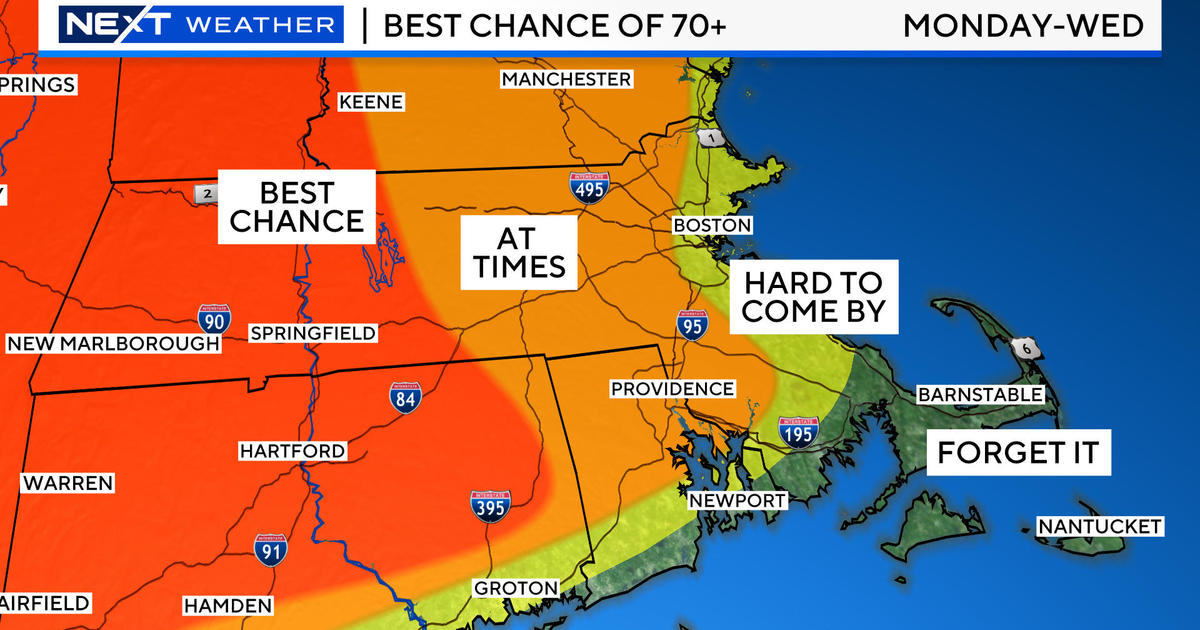
The low cloudiness may linger at least in patches over southeastern MA through tomorrow morning while the rest of eastern MA becomes sunny. The wind will become light north and west of Boston but remain brisk over southeastern MA into the afternoon. High temperatures may only reach near or slightly over 50 on much of outer Cape Cod with lower 5os along the rest of the coastline ranging up to the upper 50s well inland to near or slightly over 60 in north central MA. The sprawling high pressure system will expand and govern the region through the first part of next week. As this is happening, the atmosphere will be warming up gradually and that supports temperatures recovering to the upper 60s on Saturday to the lower 70s on Sunday and Monday to the middle 70s on Tuesday and Wednesday. On all of those days, it will be cooler closer to the coast due to the daily sea breeze keeping the numbers mainly in the upper 50s to lower 60s in most places. Sunshine should be the winner through that period although a bit of patchy mainly thinner high cloudiness is probable from time to time. During that period of time, We'll be watching the progression of a rather potent closed upper air low pressure circulation shifting across the Gulf Coast States. It is possible that this feature will eventually change course and begin a more northeasterly movement next week. .
Winter continues to wallop a narrow strip in the central portion of the nation. Snow and ice are falling this morning from northeastern KS and southeastern NE through western IA to southeastern MN and western WI. In the past 48 hours, snowfall amounts are 5" in Denver, 15" in Cheyenne to 28" at Buckhorn Mountain, CO. Some Iowa towns have received over 8" with southeastern MN just east of Minneapolis at over a foot! Meantime, our dry spell will last for another week. Hopefully, some of the moisture in the Plains States will evolve into a whirlpool of showery rain for us later next week. Until then, the fire danger and the pollen levels will remain elevated. Although there have been a few brush fires erupt in the past few days, the wind has remained below the 20 mph threshold for fire weather concerns. During the period of gustier winds starting late this afternoon into much of tomorrow especially over southeastern MA, the relative humidity will be higher which is a good thing. Nevertheless, the dry ground is a worrisome so other fires are probable in the days ahead.
Todd Gutner posts his blog early this evening and I shall return early tomorrow morning.
Make it a great day!


