Wheel Of Fortune
A weather block is in the works but we"ll be located on the sunny side this time. In many past blocking events, we've been stuck in the damp, moist, windy and cold zone and I would call it the Wheel of Misfortune. As this pattern evolves, it appears that high pressure at the surface and aloft is going to govern our weather for many days ahead possibly controlling it right through much of next week! I think that this qualifies as the Wheel of Fortune! Minor perturbations will pass through over the next several days but only be capable of producing a few spells of high and some mid-level cloudiness. We'll have some sunshine every day but some days it will be filtered to dim. We'll be watching to also see if any low clouds form and roll in to blot out the sun sometime next week. So it clearly isn't going to be clear for days and days but, on the other hand, most of the moisture which approaches from the southwest will dry up upon closing in on the New England region. A bit of rain might sneak into extreme southwestern New England on Monday but the eastern fringe of the shield will fizzle as it bumps into the western extension of the ridge of high pressure. Without any rain to cleanse the air, expect generally high pollen counts for at least the next week.
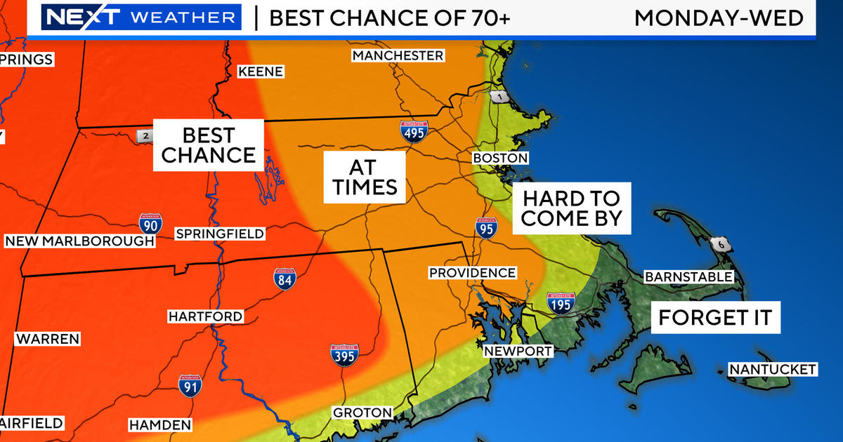
While this long upcoming stretch of weather will be enjoyable for most folks, the reality is that the precipitation deficit will deepen. Our vegetation, lawns and gardens all need a good drink now and then but this month has already been much drier than average except over Cape Cod where the 1-2" of rainfall occurred this week. Checking precipitation totals for the past few months, I notice there is an interesting flip-flop going on from almost one month to the next. Boston's monthly melted precipitation departures from last October through this April are -1.32", -2.98", +2.15", -2.28", +2.01", -1.0" and -1.8" respectively. In any event, surface conditions are only to get drier so that will increase the fire danger. Thankfully, there will not be any strong winds over the next week. The speeds will be mainly in the range of 5-15 mph streaming in from the cold ocean. That means the coastal plain will be cooled by the sea daily with high temperatures there in the 50s while farther and farther inland, it should warm up to 66-72 after tomorrow. The air mass will remain rather constant with little warming next week as the wind at almost all levels of the atmosphere flows in from the ocean. Based upon Boston's stats, the first day that the temperature reached or exceeded 80 last year was on March 22 but the first day that it hit 90 or higher was delayed until June 20. That day was the start of a heat wave with June 20-22 at 98, 96 and 95 degrees respectively. I do not see any 90 or even 80-degree days in the near future. Furthermore, with high pressure poised over the region, I expect low temperatures of 32-46 next week as nighttime radiational cooling rules in outlying lowland locations. There will probably be a few frosty pockets. May begins next Wednesday and for that month, the average high temperatures rise from 61 at the beginning to 72 at the conclusion of the month.
Todd Gutner posts his blog early this evening and Joe Joyce is on duty all weekend. I shall return early Monday morning.
Have a happy and safe weekend!


