Looking For A Brief Warm Up In A Cold Pattern
Snow showers and snow squalls are advancing towards the outer Cape and National Seashore which could deposit another coating to 1" of snow. Otherwise, Saturday is a bright sunny and cold day. Temps starting in the single digits and teens will eventually climb into the lwr-mid 20's by afternoon. Watching an energized short wave spilling in from the Great Lakes this afternoon which will provide enough lift to make for a few afternoon clouds and skies becoming partly sunny. Winds will pick up from the NW with this approaching shortwave and make for a wind chill factor in the single digits and teens. This front will push through tonight with clearing skies, breezy blustery winds and lows again dropping into the single digits and teens. This reinforced shot of cold air from Canada is being supplied by a cold high pressure from Canada which will crest over us Sunday. After a breezy start, skies will be filled with sunshine Sunday and highs climb into the mid-upper 20's.
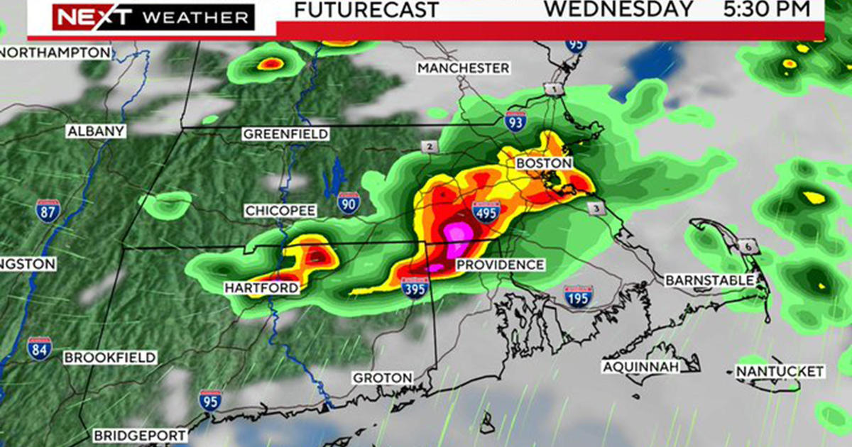
Rain which is currently in the desert SW of the US will move across the nation and arrive in the Northeast on Monday afternoon. Temps will be cold enough Monday that once this moisture arrives, as a warm front, most of the precipitation should fall in the form of snow as it runs into the cold dome of air in place across New England. Some models hint at this snow mixing over to a touch of freezing rain before it ends early Tuesday morning. Accumulations of 1-3" are possible with this approaching warm front Monday afternoon and evening. The boundary will be stalled and lay across SNE through Tuesday keeping clouds in place with temperatures slowly starting to moderate and the cold air finally eroding. Right now, Tuesday looks fairly dry with temps trying to climb back into the lwr 40's across parts of SNE by afternoon. A few scattered showers possible into Tuesday night. The warm front will finally lift northward by Wednesday morning with SW winds pushing in a balmy airmass ahead of an approaching cold front. With an upper level ridge becoming established on the east coast, temps should be able to climb into the Lwr 50's ahead of the cold front.
This front will be push west to east late Wednesday through Thursday morning. A wave of low pressure may try to develop on the front making for a period of Heavy rain during the early morning hours of Thursday. Rain showers may change to a brief period of snow showers before the cold front sweeps offshore as colder air will be following in with breezy NW winds. These winds from the NW will steer back another shot of Arctic air for Next weekend...the first weekend of February. This airmass will rival the depth of the cold we just experience this past week.
Plenty of cold is expected for the Month of February. The polar Vortex looks to remain near Hudson Bay in Canada which is a prime spot to continue to steer in cold arctic airmasses into the Northeast. Out weather will be controlled by the Northern polar stream for much of the month keeping temps below normal. The question will be if it can merge with the subtropical jetstream which tends to supply the moisture...so we can get a good storm to form before this winter is through. We are officially on the clock. Our coldest days of the winter are now behind us. We have a putrid 7" of snow this winter in Boston..time is running out, but this February should deliver.