Bone-Chilling And White!
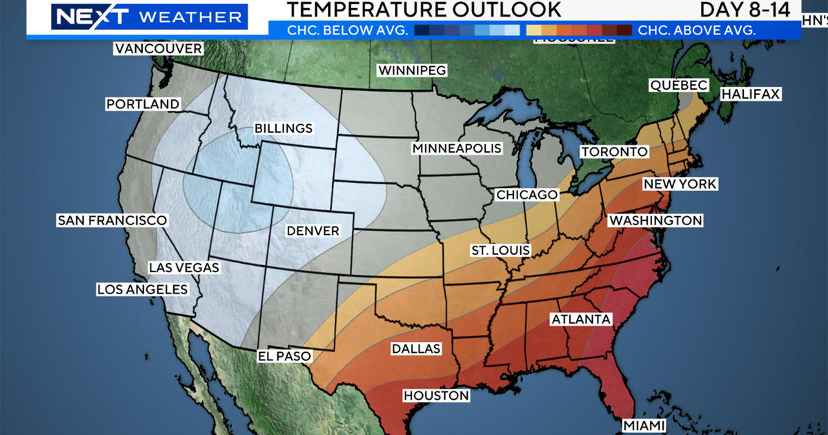
The amazing swings in temperature continue and winter is back this morning! After last Monday's 61 degrees, a decline to the lower 40s occurred then we got a 1-day cold shot in the lower to middle 20s on Friday. The weekend spoiled us again with highs of 50-55. Now we're right back to bad habits but this time the cold will be of long duration up to a week. Looking way ahead, it may turn much milder by the middle of next week with a rain storm! In the meantime, we will experience bone-chilling conditions with some subzero readings in the northern and western suburbs on the early mornings of Wednesday and Thursday this week.
The cold is a sure bet but the snow threats are not certain in the days ahead. The first enigma evolves late today and lingers through the morning commute tomorrow. Presently, there is a weak trough of low pressure across the Great Lakes. It looks rather innocuous and should remain that way until late tonight when it aligns along the coast. This boundary will act as a focus for a narrow axis of heavier snow. This type of specialized "Norlun Trough" is tricky to predict and in my nearly 40 years of forecasting, I can state that it is about as forecastable as the Northern Lights! Under premium conditions, these troughs can be prolific releasing an amazing amount of fluffy snow in a very narrow ribbon. It is more of an instability, convective event similar to getting drenched in a local thunderstorm in the summer. The convergence zone restricts the intense snowfall to a small strip much like what happens in the slivers of intense lake-effect bands of snow around the Great Lakes. Around here, this is an ocean-enhanced phenomenon and since the sea is several degrees above average, the stakes could be high for some whopping snow totals with the arctic air streaming in overhead. The disparity in snowfall amounts over a short distance can be astounding with a range of 2 to 22 inches but the conditions must be absolutely perfect for this to happen and I have only seen a handful of these cases over the last few decades. Consequently, the chance of this materializing is low. The precise placement of this snow band is paramount to forecasting accurate amounts. Any slight wobbling or shifting of the band suggests there is a big bust potential with this setup. For now, I can only be comfortable in saying that the riskiest region will be southwestern ME, southeastern NH, northeastern MA, the South Shore and parts of Cape Cod. This is exactly the area where a Winter Storm Watch has been issued by the National Weather Service. As the weak clipper system emerging from the Great Lakes transitions southeast of New England and intensifies, it is only then that we can determine with greater confidence just how potent the trough will become. Monitoring developments this evening will be crucial to postulating the end result. With all of that said, for much of the area, I am convinced that a dusting up to 3" is likely. The wildcard route is the coastal plain.
Clouds will gather during the day and the snow showers will break out across the region deeper into this afternoon. There should be a widespread area of light snow this evening with the potential of blossoming into bursts of heavier snow along the coast. The snow will end over inland locations before dawn but linger along the coast through the morning commute then shift offshore by 9-11am. After light winds this afternoon and highs in the 25-30 range, the wind will refreshen to 15-30 mph tomorrow from the northwest with temperatures struggling to rise a couple fo degrees from the morning lows near 20. The cold climax will happen over a 36 to 48-hr period from early Wednesday to late Thursday night. Expect highs of 10-15 Wednesday and 15-20 Thursday despite bright sunshine with overnight lows near or slightly over zero in Boston to subzero readings of -5 to -10 north and west of Boston to the upper single numbers to lower teens on outer Cape Cod.
Looking ahead, the next snow threat for Friday looks like a minimal storm of just a few inches. The storm track well south of New England will keep this all snow except for perhaps the islands. Since this weather maker is 5 days away, there is time for some tweaking of the storm path so it bears watching. In any event, the system will exit Friday night and just a few residual flurries may be falling over southeastern MA next Saturday morning otherwise the weekend should be sunny to partly cloudy. Cold air will continue to flow out of Canada but it will moderate over the harsh conditions of midweek. Expect highs both Saturday and Sunday in the middle 20s with a brisk cold wind.
For skiers, riders and snowmobilers, conditions are good overall but a big snowfall is needed to freshen up the trails. Unfortunately, there are none in sight but snow making will be running very efficiently over the next several days thanks to the presence of dry, arctic air. For now, the primary surfaces are packed powder with loose granular. Watch out for thin spots and scratched-off icy places where traffic is heavier especially on steeper slopes. It will be paramount that you dress appropriately for intense cold and windchill. Layering of clothes that are not bulky is important and augment that with a gaiter, face mask, helmet, goggles and warm mittens over gloves. You can still have a dynamite time on the trails even when it is frigid. Take breaks and avoid skin exposure and frostbite.
Todd Gutner will post a fresh blog late today.
Make it a great day!


