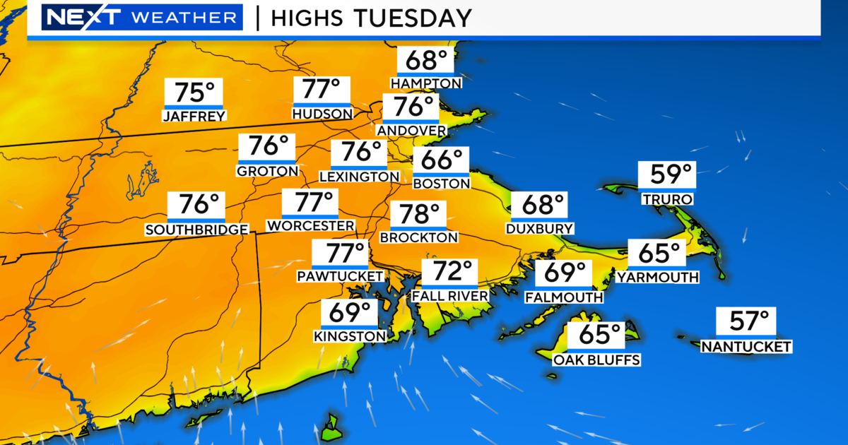
Awaiting Arctic Air
Temperatures have been on a roller coaster ride this week with 61 Monday afternoon to 26 yesterday afternoon to 49 this afternoon. More big swings are upcoming. January 2nd and 3rd were the only two really cold days so far this month but we have 6 or 7 consecutive days of below average temperatures on the way after tomorrow. So enjoy it while it lasts with lows in the middle to upper 30s tonight then at least up to the middle 40s tomorrow. After that, there will be subzero readings north and west of Boston on the mornings of Wednesday and Thursday. It looks like my 2-week advertisement of the arctic chill is going to materialize. Boston's low temperatures will probably bottom out near or perhaps slightly below zero. The last subzero day in the city occurred on January 24, 2011 at -2 with the previous subzero day 6 years earlier on January 22, 2005 at -2. One of the coldest January days happened on the 16th in 2004 at -7! That January contained 4-subzero days in Boston and was one of the coldest Januarys on record at a whopping 8.6 degrees below the average! Contrast that with last January at 5.2 degrees above average. After last winter's incredible warmth, you will really be shivering with several bitterly cold days in a row in the week ahead. Interestingly, this cold spell is nearly coincident with the coldest days on average of the whole year namely January 20-25.
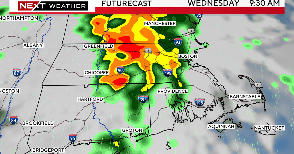
While the cold is certain, snowfall is uncertain. Weak upper air support will traverse the region later Monday into Tuesday morning. This should at least create scattered snow showers. As a storm begins development just offshore, an inverted trough may extend northwestward into eastern sections. Consequently, with a convergence zone along the coast, there could be a period of steadier and heavier snow before the system exits. While I cannot totally rule out accumulations of a few inches, I believe that the setup will not be perfect for this to occur. Looking farther ahead, another package of energy in the jet stream will be percolating a storm in the central and southern Plains States late Wednesday into early Thursday. Presently, most signs suggest this system will swiftly transit to the East Coast with most of the intensification materializing as it is passing just south and east of New England. As a result, I am currently predicting a period of snow on Friday. It is too premature to be confident on the strength of this feature. I think that it will be progressive enough to limit the snowfall amounts but all of the parameters cannot be accurately determined at this stage of the game. It bears watching.
In more detail, as a cold frontal boundary approaches from the west and its parent low pressure system deepens just north of the Great Lakes and travels over the st. Lawrence River Valley in the next 24 hours, the brisk wind will continue in the Northeast. It will remain mild tonight then turn colder late tomorrow after the passage of the front. There will be snow showers over the northern mountains but there is only a slight risk of a brief sprinkle or shower across southern New England at midday or early afternoon tomorrow. For attendees at the big game at Gillette Stadium, temperatures in the middle 40s at mid-afternoon for tailgaters will drop to the middle 30s by kickoff at 6:30pm then down to the upper 20s by the end of the 4th quarter. The gusty westerly wind of 15-35 mph will chill the air and decrease a bit tomorrow night as temperatures reach mins of the upper teens to lower 20s early Monday morning. Expect highs of 25-30 Monday then only 20-25 on Tuesday as the arctic air takes control. The coldest period should occur from late Tuesday night through Thursday morning. After that, there will be some moderation to the 20s for Friday, Saturday and Sunday. As the Friday storm becomes stronger out over the ocean, more cold air will be drawn into New England with strong gusty winds but it will not bequite match the magnitude of the Wednesday-Thursday chill. The surface wind next weekend may have an ocean component leading to periods of snow or snow showers over Cape Cod and southeastern MA so those areas could receive some accumulating ocean-effect snows of just a few inches in spots.
For skiers, riders and snowmobilers, conditions are generally good on many trails up north but the reality is that a big snowfall is needed to open up all of the trails including the glades. The balmy weather several days ago did not help and there really has not been a decent storm in a while. Nevertheless, many of the northern resorts have picked up a few inches of snow which have freshened the trails but it was insufficient to open more substantial terrain. Overall, with nightly grooming, primary surface conditions are packed powder and loose granular. Due to the long holiday weekend, keep in mind that higher than average skier and rider traffic will create scratchy and thin spots in some areas by midday. The best conditions usually can be found the first few hours of the day. Snow showers are likely over many of the northern mountains on Sunday but the arctic air will then dominate the rest of the week with only a slight risk of snow showers. However, conditions will become perfect for efficient snowmaking the all of next week. The Friday storm is indeterminate but we will remain hopeful for some fresh inches at that time.
Joe Joyce delivers his latest AccuWeather Forecast in the morning and I shall return in the afternoon.
Have a safe and happy holiday weekend.