Temperature Inversion
We're starting off this 13th day of January with temperatures already about a half-dozen degrees above the average high for the day. So far it hasn't felt like a genuine January thaw due to the high moisture content of the air. It's damp and dreary and the air is saturated resulting in widespread fog. The National Weather Service has extended the Dense Fog Advisory to 11am. Allow extra travel time this morning due to reduced visibility in some locations. With the weakness of the January sun and an absence of any other strong mechanism to burn off all of the extensive low level moisture, we will not be experiencing the surge of warmth that is flowing up the eastern seaboard. Instead, the warm air is streaming right over the top of us. To prove that point, the summit temperature at the Mount Washington Observatory jumped to 48 degrees at 6am. This breaks the old record of 47 for the warmest January day ever on record!! It was warmer up there than it was in places like San Diego, Los Angeles and Phoenix this morning! Meantime, at the surface, the warm air is arriving in western NY and PA where Erie rocketed to 66 and Buffalo 64! The warm air is just a few thousand feet away vertically and a few hundred miles away horizontally. Last Sunday, I speculated that Boston could tie or break the record for this day which is 63 set in 1932. Seven days ago, it was impossible to foresee the scope of this low-level moisture that is spoiling that prediction. Anyway, I will optimistically shoot for the middle 40s to near or slightly over 50 across the region this afternoon assuming that the fog will gradually lift and the low overcast may thin enough for some slight brightening in spots. A south-southwesterly breeze will slowly freshen to 5-15 mph during the afternoon into tonight. At Gillette Stadium as the Pats host the Texans, a kickoff near 50 degrees will not change much throughout the contest under a cloudy sky with a low risk of mist. The temperatures will likely hold constant or perhaps rise slightly in some areas overnight as areas of fog take over again.
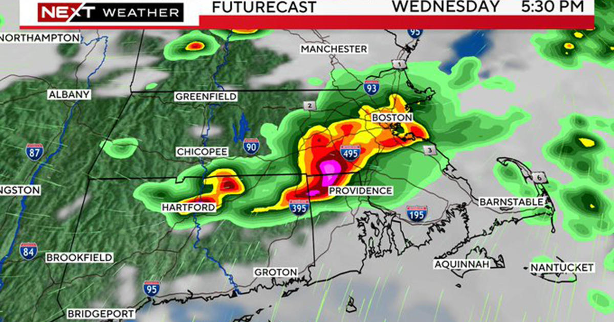
As a cold front swoops eastward across the area tomorrow, all of the low-level moisture will be scoured out. This front is currently generating a solid swath of showers and embedded thunderstorms from the eastern Great Lakes south-southwestward to the Louisiana coast. The front will lose support here in the Northeast so I am expecting nothing more than a few spotty showers around here tomorrow. As the air dries out and it becomes partly sunny, it should be up to 50-55 in the morning through midday before it turns cooler in the afternoon. As the front settles south of the region late tomorrow, a couple of waves of low pressure will run along the boundary through Wednesday. The first one will skim by with its cloud shield over southern New England and some sprinkles on the South Coast tomorrow night. It will clear out for some bright sunshine Tuesday. The second wave's cloud shield will appear late Tuesday then disappear southward around midday Wednesday. The high temperatures will still be running up to 3-6 degrees above the average in the upper 30s to lower 40s Tuesday through Thursday. Next up is an approaching sharp cold front barreling eastward from NY and PA on Thursday. Its ETA in the Boston area is 2-4pm Thursday so a brief shower of rain or snow cannot be ruled out. It will turn windy and we will capture a piece of the arctic air from Canada. That means that I think Friday's highs will only be in the range of 23-27 degrees with a cold, brisk wind in the morning.
Looking ahead, it appears that the cold air mass will retreat northward Saturday as a warm frontal boundary grows eastward across NY into New England. It could become active with light snow or flurries breaking out north of the frontal boundary mainly over northern New England. Warmer air will start flowing in from the southwest so it will recover to the middle 30s on Saturday then possibly jumping another 10 degrees to the middle 40s next Sunday. After that, timing of systems becomes fuzzier but I am becoming more and more convinced that a couple of episodes of frigid arctic air is in the works. The first parcel could be introduced by some sort of developing storm near the area later on Martin Luther King, Jr. Day. It is too premature to be highly confident but I do see signs that some of the coldest air in several years could be charging into this nation including New England. My advice is to enjoy the mild weather of the next few days.
Skiing, shredding and snowmobiling continues with good conditions on groomed trails. Despite good coverage and relatively deep snows in places, the reality is that a nice big fresh snowstorm would be much appreciated. The glades and non-snowmaking slopes need it the most. Anyway, that storm does not look to be in the cards this week but perhaps something will blossom as the arctic air is introduced next week. Meantime, many resorts will be resuming some snow making by mid-week as colder nights return. Always be prepared for changing conditions and please be safe and courteous on the trails.
One additional tidbit of information is about the extra high tide at noon today. Due to astronomical conditions, the tide height is enhanced again today to almost 12 feet which will produce some flooding of the more vulnerable low-lying areas resulting in some road closures such as portions of Morrissey Blvd. in theBoston area. There can be some minor splashover in other prime spots. Fortunately, no storms generating winds or high waves are present for this tide cycle.
If any new data warrants any change in my thinking, I will post an updated blog this evening. Otherwise, Melissa Mack delivers her latest WBZ AccuWeather Forecast in the morning and Todd Gutner follows later in the day.
Make it a great week and GO PATS!