More Snow...
On Thursday, Northern New England got hit hard by snow, Saturday it will be Southern New England's turn. The storm is heading out of the Deep South where it picked up Gulf of Mexico moisture and is now traveling northbound, destined for the Northeast. The track will take it offshore, south of Nantucket, which is a pretty good snow track for Southern New England...SE Mass especially.
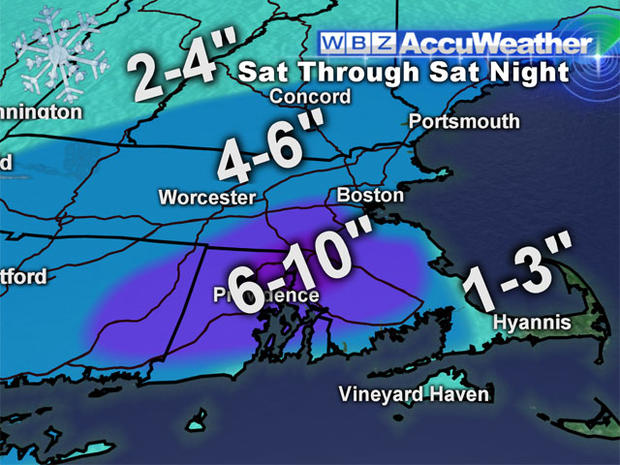
Light snow will break out early Saturday afternoon and it will snow through most of the night, ending very early Sunday morning. At the start, the snow will be very light and not much will accumulate over the first several hours. However, after dark, as the storm consolidates and strengthens over the ocean, the snow intensity will pick up and some banding can be expected leading to several hours of moderate to heavier snow. The storm will blow up out over the ocean into a major Nor'easter...by all accounts that will happen just a bit too late for a major snowstorm here...but it is something that will need to be monitored closely. Most will see 4-6" of snow with a little less near and over the NH border and a little more in Interior SE Mass where most of the banding will occur. There will also be some mixing or at the very least a much wetter snow for the coastline and the Cape and Islands holding amounts down.
Thankfully, this does not appear to be a very impactful storm...not much wind outside of the Cape, no coastal flooding concerns and for the most part the snow will be light and fluffy and easy to move around.
Following the storm, winds will howl on Sunday and eventhough the sun will return temps will feel like single digits and teens. Kick-off is at 4:25 for the Pats and Dolphins and I expect temps to go from 30 down to 25 by the end of the game...winds won't let up much either.
Next week looks quiet from a snow perspective but man is it going to get cold! We will see multiple blasts of Arctic air, with highs in the 20s, we are facing the coldest air in almost two years! The first blast will arrive on New Year's Day and the second next Friday...the leading edge of each blast may have a snow flurry or snow squall associated with it.