Big Warmup Ahead
Brrr was it cold this morning! The majority of the region finally got their first official frost of the season, with several locations dipping well below 30 degrees. Some recorded low temperatures from this morning include 22 degrees in Andover, 25 degrees in Townsend and even 33 degrees here in the city of Boston. As cold as we're starting off the day, temperatures will rebound substantially this afternoon with high temperatures making it into the middle 50's, thanks to abundant sunshine and crisp, clear blue skies. Winds will be light from the west at 5-10 mph.
Tonight, high clouds will begin streaming across the region from the west ahead of an approaching warm front. This warm front is lifting north in response to the retreat of a strong area of high pressure, and as this high retreats winds will turn southwesterly, ushering in moisture and warmer temperatures. As a result, with this increase in moisture and some weak lifting in the atmosphere, showers will break out across the region shortly before dawn, and look to last through at least noontime before tapering off from south to north. When this rainfall and the associated cloud cover retreats will be the limiting factor on just how warm our temperatures get Sunday afternoon. Latest computer model trends are keeping skies mostly cloudy through much of the afternoon, and as a result we expect high temperatures to be limited to the lower 60's. However, if the warm front lifts north more quickly than anticipated, high temperatures will warm rapidly into the upper 60's as we will be in the "warm sector" behind the warm front. Thanks to a strong pressure gradient winds will be gusty from the southwest at 20-30mph.
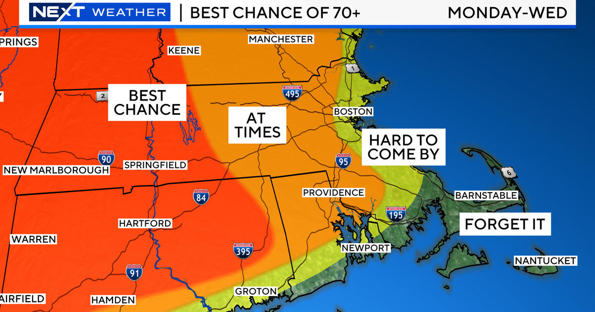
Overnight Sunday temperatures will be rather mild thanks to a moist southerly flow and the presence of some cloud cover. Monday morning there may be a few clouds around, but as we head into the afternoon sunshine will appear from time to time, which will boost temperatures to an unseasonably warm 75 degrees across much of the area. Not bad for October standards! This surge of warmth is occurring in response to an approaching cold front. As the front gets closer towards the evening, some showers may cross the region from west to east. Any shower activity should be rather light and isolated in nature however. By no means will Sunday be a washout. There are some indications that a secondary disturbance across the Mid-Atlantic will travel northward, and as it interacts with the frontal boundary a deepening low pressure center may result. This could provide the region with a second burst of rain Tuesday morning. In contrast, some of the more reliable guidance is pushing any such disturbance well offshore and away from New England. As a result, I do expect increasing sunshine Tuesday afternoon, with the isolated threat for some morning rain. High temperatures should be seasonable in the middle 60's.
As we head into the middle of next week, the overall synoptic pattern looks to get quite amplified. A deep upper trough will be digging down from southern Canada. As it does so, it will drive a cold blast of air into the central part of the country. Farther east where we are, upper-level ridging will be the response. With ridging in place, winds will turn southerly, and this will keep us in a seasonably warm air mass with high temperatures Wednesday and Thursday in the lower to middle 60's. Also, both days should feature ample sunshine as strong downward motion in the middle levels of the atmosphere will act to dry out the air column, keeping cloud development to a minimum. Thus, at the expense of the cool and unsettled midwest we get an excellent pattern. Nice!
Unfortunately, as much as we'd love to see this pattern continue, it will eventually translate eastward, and eventually the cool and unsettled weather from the Midwest will make its unwanted appearance here in New England. Thanks to a complete and utter lack of consistency amongst the computer models, the arrival of this unsettled weather is rather uncertain. Regardless, it does appear as if Saturday will see the best shot at clouds and rain.
Make sure to enjoy the fantastic weather today and take advantage of the last few weeks of fall color!


