Splendid To Soggy
Oh, man, there was a nip in the air early this morning with many of our WBZ WeatherBug Network stations recording lows in the lower to middle 40s. Thanks to ample sunshine provided by a sprawling high pressure system, we'll enjoy some more splendid weather before it turns soggy late Tuesday night into Wednesday morning. There will be some scattered small puffy cumulus clouds popping up in places along with a few filaments of feathery cirrus clouds possible but the day will be dominated by the sunshine pumping temperatures up to near or slightly over 70 degrees. The air is very dry and crisp and the westerly wind will blow up to 5-15 mph. It will be perfect today for golfing, running, walking, biking, hiking, apple-picking and watching the Pats win at Gillette Stadium. For you body and board surfers, the rollers are again building on the New England coastline especially around the outer Cape thanks to waves propagating across the Atlantic from Hurricane Nadine centered about 1100 miles west of the Azores. A HIGH SURF ADVISORY is posted so check out the details from the National Weather Service. Check out some of the surf cams such as this one at Coast Guard Beach on Cape Cod. It looks like some breakers cresting near 10 feet there at times! WOW! Beware of this dangerous surf and its accompanying rip currents. The tide is high at 11:53am.
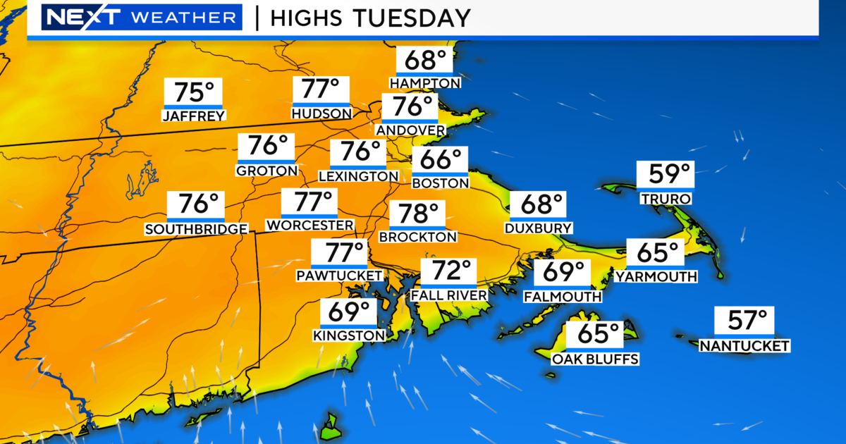
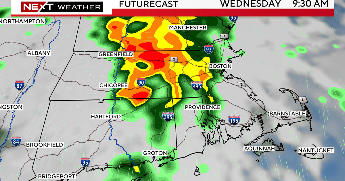
After another cool night in the upper 40s to middle 50s, it should be mainly sunny tomorrow with a more southerly breeze up to 15 mph as the high pressure system builds off to the south of the region. On the back side of this feature, more moist air will begin to stream north-northeastward resulting in a little bit of cloudiness arriving as temperatures rise higher to 74-78. The air will be generally dry through the day with a gradual increase in humidity later Monday night and especially during Tuesday afternoon. Presently, it appears that most of the approaching wet weather will be delayed until Tuesday night but a few renegade showers probably cannot be ruled out later Tuesday afternoon over mainly western New England. The weather is definitely destined to turn nasty later Tuesday night through the Wednesday morning commute. Blame this on an amplifying trough of low pressure which will dig sharply into the eastern U.S. The configuration of the jet stream will cause a capture of tropical air from the deep South and this will surge into the Northeast ahead of an approaching cold front. Consequently, expect a moist conduit of heavy rain with embedded thunderstorms plus strong, gusty southerly winds up to 25-45 mph. The frontal boundary will shift across the Boston area in the mid-late morning timeframe on Wednesday. Drier, cooler and more stable air will produce clearing in northwestern New England Wednesday afternoon. However, the clearing line may commence deceleration later Wednesday as the front becomes parallel with the upper flow. It is inevitable that the front will become quasi-stationary at some point. Exactly when and where this occurs will determine what happens over especially southeastern New England the second half of this week. Currently, I have low confidence about how this is all going to shake out so I am leaning in the direction of holding periodic rain over southeastern MA and Cape Cod on Thursday and possibly Friday and Saturday. This evolving weather block over the Atlantic will push westward resulting in sluggish to little eastward displacement of weather systems. If the front stalls 50-100 miles farther offshore, the rain will be displaced out to sea. It is a close and tough call at this time.
If there is a change in this scenario and greater clarity later today, I will post an update this evening. Otherwise, Joe Joyce will deliver his AccuWeather Forecast tomorrow morning for the vacationing Melissa Mack and Todd Gutner will follow with his thoughts later in the day.
Enjoy the rest of the weekend and GO PATS!