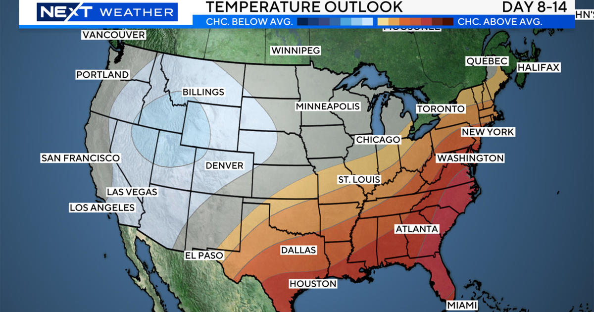
Snow Storm Could Bring Widespread 12 To 16 Inches
BOSTON (CBS) - Here we go! Nor'easter 2011 is taking shape and now is nearly a lock for Wednesday.
Read: Weather Blog | Forecast Maps | Snow Emergencies
Lots of people are asking how this will compare to the blizzard of December and I would say that the snowfall comparisons should be relatively close.
The good news is the coastal devastation and hurricane force winds will not be present this time.
TIMELINE
Snow begins shortly after midnight on the South Coast and around 1-to-2 a.m. in Boston. By 4 a.m. it will be snowing heavily (1 inch per hour) in all of southern New England making for a horrendous morning commute.
Snowfall continues heavy through the morning and early afternoon, begins to taper late afternoon and evening.
The Winter Storm Warning expires at 7 p.m. Wednesday, which seems reasonable for an approximate end time.
SNOWFALL
Nobody is really going to escape this one.
A widespread 12-to-16 inches is likely with the lone exception of Cape Cod, the Islands and perhaps along the South Shore near Plymouth.
Down there some rain or sleet should mix in holding amounts to 6-to-12 inches (South Shore) and 3-to-6 inches (outer Cape).
As for the jackpot area, tough call, likely somewhere in Metro West, within 20-30 miles of Boston where there may be a band of thunder snow dumping 2-to-4 inches in an hour.
No doubt that there will be a few spots which could reach 18 inches or slightly higher.
The snow will be a light and fluffy consistency inland of 495, and, therefore, we may see a bit of a "fluff factor" out there.
Snow could pile up higher out there as snow-liquid ratios could reach 20-1. (20 inches of snow for every 1 inch of precipitation)
Closer to the coast, the ratio will be nearer to 10-1, lending to a heavier, wetter snow, especially along the South Shore and Cape Cod.
Watch Todd Gutner's forecast
WINDS
The winds will be strongest over the outer Cape and Nantucket (where there is a High Wind Watch).
Out there winds will be 30-to-50 mph with gusts to 60 mph.
Elsewhere, northeast winds should average 15-to-35 mph with gusts as high as 50, especially near the coast. This could certainly cause some wind damage.
COASTAL CONCERNS
Thankfully the tides are astronomically low, nearly 3 feet lower than during the blizzard.
So, therefore, the coastal flooding threat is minor.
High tides occur just after 4 a.m. and 4 p.m. on Wednesday, but we're not expecting much more than very minor issues.
Beach erosion will continue to be a major concern in vulnerable areas.