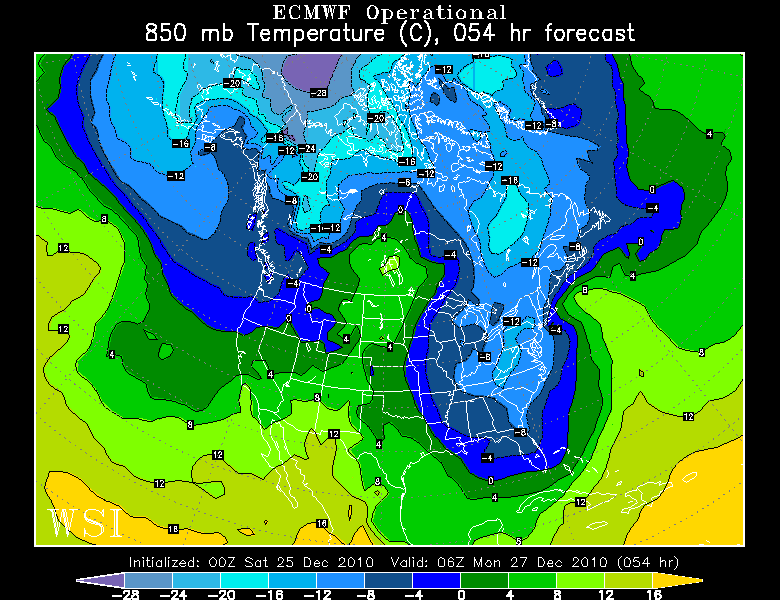
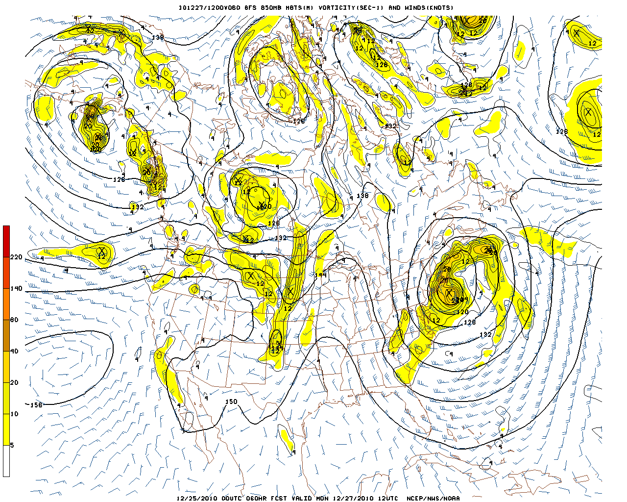
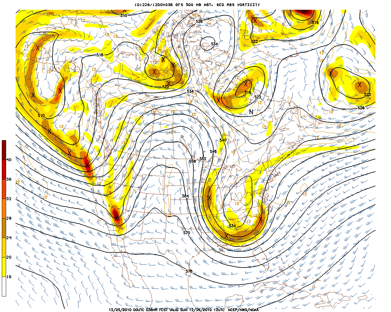
What a week it has been! What a Christmas present this could become for Snowstorm lovers! The Back and forth has been maddening. Glad to see the models finally starting to catch on and handle the energy involved in this pattern. A concern was how , when and where the northern stream and southern stream would merge. Things seem to be falling in place not for the pattern to develop a major winter storm for the Northeast. Check out the upper low at 500 tomorrow morning.
The streams have merged. The upper low has shifted west from earlier runs and is in a perfect place for the storm to explode once it reaches the coast and be directed towards New England.
Watching the 850 temps for warm air advection into the storm. Depending on the eventual track ..There could be some boundary layer issues over the Cape and Islands with a change to rain. The snow rain line may try to push up to Plymouth..but that is as far north as it is going to get. There will be a coastal front which will become a convergence zone for enhanced snowfall which I think will set up south of Boston. Look for the -4 to -8 C lines on the 850 map. That is where we will see the best snow growth with ratios of 15 to 1.
We are always trying to find out where the band of heavy snow is going to occur….which I believe will be just on the other side of the coastal front…likely from the Attleboro /Taunton area to Boston. Snowfall will be coming down at 2″ an hour at times and I fully expect blizzard conditions to develop as winds really start to howl with this deepening storm south of Boston.
The Heaviest snow band tends to occur about 90 to 120 nautical miles to the NNW of the 850 mb low. What does it look like to you?
That patterns looks like Eastern MA is going to be crushed with heavy snow overnight Monday. I will be live in Scituate Monday morning at 4:30. That could be pretty intense huh?
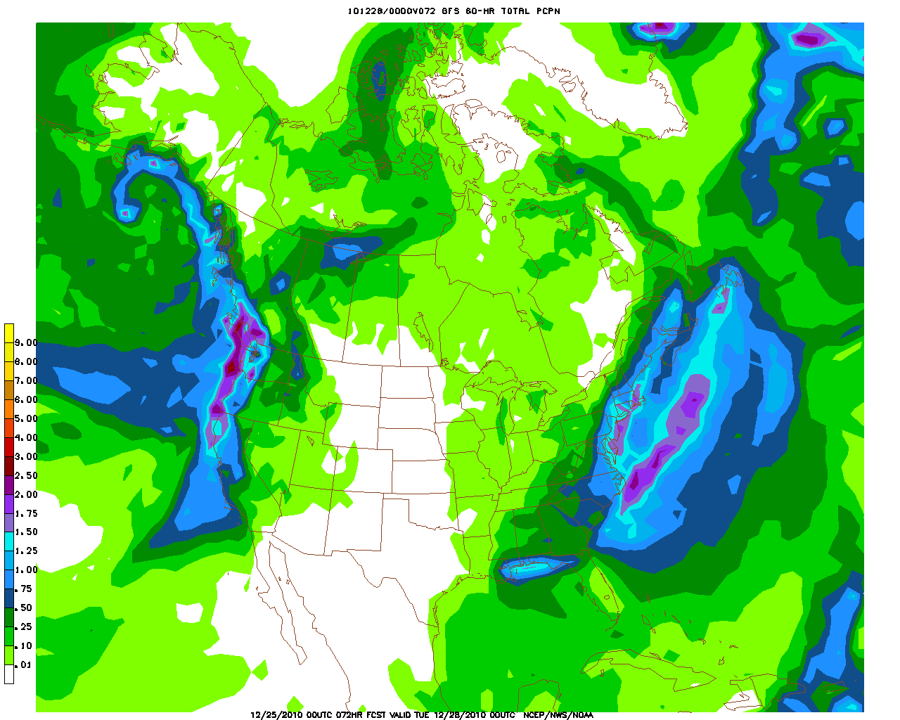
How much snow are we expecting? This storm is loaded with moisture. Significant overrunning will take place . Here is the QPF from the 00Z GFS. My apologies if some of this is hard to see. Printing over 1.5″ of liquid Boston south. My concern this morning is some of my numbers could be underdone…but there is time to fine tune. There is the potential for 12-18″ of snow if this storm verifies the way it looks this morning. Where there is colder air inland away from the coast…there will be better snow ratios…so despite less moiture..snow will continue to pile up…that is why I am expecting a foot of snow from Worcester to Manchester NH. The potential for a foot even near Plymouth…with amounts totaling over 1 foot in between.
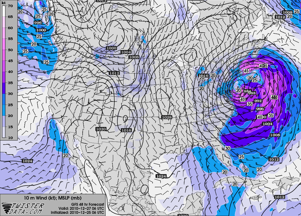
The Winds are another major part of this storm. This storm is going to bomb south of New England as energy rounds the base of the trough and shoots off the coast. Howling winds at 850 to 70-80 kts will have a chance of mixing all the way down to the ground. Sunday Night into Monday morning will be the peak of the wind at the coast where there is the potential for wind damage and power outages. Check out the surface winds around Sunrise Monday out of the east. Incredible.
Winds will be gusting easily over 50. There is the potential for even a few hurricane force wind gusts. This could get really nasty. Onshore winds with high tide around 3:30 AM during the peak of the storm could mean minor to moderate coastal flooding for eastern facing beaches. Expect full whiteouts. Travel should be avoided Sunday night through much of Monday. This has the potential to be a major possibly historic winter storm…Certainly there will be more adjustments to track, snow totals, ect in the coming hours. I am here for the rest of the day. Barry “The Legend” Burbank takes the wheel tomorrow! Todd Gutner Tomorrow Night. See you in Scituate! Let’s hope this time the forecast sticks. Merry Christmas to everyone. Thank you so much for your interest in weather and WBZ news. We so appreciate your support and value your viewership and input in tracking these storms!
My plow is ready
Models have gone nuts , predicting a 960 mb low near the benchmark , blizzard watches or warnings will be later tonight
Somethings to keep in mind – The local mets have a forecast area of vastly different regions. The Cape and Islands all the way out to Southeastern Vermont and the eastern part of the CT River Valley of Massachusetts. So what may be a giant storm for some may not be so big for others.
There are somethings with the modeling of this storm I am not comfortable with. Look at the 00z NAM MOS for ORH. It has dew points of in the mid teens yet wants to dump LE precip of 15” that seems suspect to me. The dew points actually drop when the most precip is supposed to falling. Despite this dry air the NAM’s snow tool is only converting it to 7-9” of snow. Then highest POP for a 6 hour period is 80. Other times during the storm it is in the 55-60 range. All this tells me the models are still have significant problems ingesting the data and processing it to a logical conclusion.
I believe within 24hrs the models will start to run home to mama or closer to their original solutions. My thoughts have not changed much. A more significant storm south and east of Boston with a moderate to heavy snowfall. A moderate snowfall west of 128 to 495. ORH in the light-moderate category and lighter amounts with sharp cutoff west of there.
This may not be the sexy solution, but I believe it is the more prudent one.
Merry Christmas to all. Even all those one here who exist multiple times….
JMA, I am with you. Models may trend east a little. I see decent snowfall but not some dumpster.
If dumpsters start falling from the sky, we’re in trouble. ;-)
Good luck Monday morning in Scituate Joe! Going to be incredible there at that time!
Lots of buildup and excitement and then it will be a huge letdown to all.
there are going to be some serious drifts from this storm
Merry Christmas JJ! Thanks for the present…Blizzard conditions are on tap!!
I see this as almost a 24 hr storm along the coastFirst flake to last flake. How are you seeing this Scott and others?
there is a chance for blizzard warnings to be issued by tomorrow morning. hopefully the afternoon runs dont change
Keep mix away from East Bridgewater
cant wait for the 12z euro to come out. should be interesting!
If this storm does explode as much as it could, how doesnt it cutt itself off from the progressive flow as it becomes vertically stacked???? Ideas?
No stacking & stalling this time. Not the right synoptic setup.
Thanks Joe and Merry Christmas.
My forecast.
350+ blog comments by day’s end.
Thanks Joe!! Merry XMas.
Looks like I will be inn the thick of it in Maine as well.
I’d echo ralph’s question. At that strength, does it become a much slower moving system? Are there any indications that it is trending less progressive than earlier thought? Or will it be quick and intense. it would be good to know for travel later monday
Im no expert but it doesnt look very progressive to me anymore. Can somebody else with more experience comment onTims question.
from henry
http://www.accuweather.com/blogs/meteomadness/story/43504/big-daddy-of-2010-on-the-way.asp
Excellent Blog Joe!!! Thank you!
Merry Christmas to all bloggers!!!
Looks like a biggie!!!
Joe Joyce come on now!! this will be a good foot of snow ,nothing we havent seen before.your blog is overdone just like your noon report yesterday. historic? i dont think so. i know its xmas but chill out pal!!!
Mike, you relax…JJ is merely reporting what could be a whopper…..when you have the potential for over 15 inches with winds 50-60, that is a major storm. So instead of mocking someone that knows a million times more about weather than you, maybe you should just focus on opening your Xmas gifts or something, instead of mocking JJ who is delivering great updates for the public.
JJ does NOT know that much more about the weather. NFW
Still feel we are not going to get a storm of that intensity. Not saying it isn’t gonna snow, but I do not think it will live up to the hype IMO.
12″ snow and 50mph winds is a BIG deal!!! And we have not had a storm like this in years.
Some of us have. There have been a couple storms like this one in recent history in eastern New England.
I will never forget shoveling 28″ of heavy wet snow on April 1st, 1996 in Plainville, MA.
I am sure that you mean April 1st, “1997”.
What would you compare it to topkatt? Been plowing 30 year beeen in every storm.
The first storm that comes to mind is March 29 1984, if it lives up to potential.
This thing has flipped-flopped every day. What’s the chance of waking tomorrow morning and it’s OTS?
It happened in Jan & again Feb 1987. It happened other times. Though it’s not likely, it’s still not out of the question.
Down here in Plymouth and that after-Christmas storm in ’04 was a beast. Lost power for 36hrs. Not looking forward to a repeat…
That was interesting storm. I was living in South Boston at the time and working down on Congress Street at Russia Wharf. A lot of wind and heavy wet snow fell that day. IIRC the Tea Party ship broke away from its mooring and also right next to that was a very large houseboat that had been converted into office space and was anchored to Russia Wharf. Well sometime during the day or night that house boat partially sank. Wild Storm.
There were alot of cloud-to-ground lightning strikes at the height of that snowstorm (3-29-1984).
That will be something to watch for tomorrow night and Monday. That and the heavy wet snow. I’ve got all sorts of antennas for my radio hobby including a large 50×130 wire loop antenna that I will try to keep the snow off of.
Why does a storm I got caught in back in Feb 1969 never get any press, prior to the Blizzard of 78 it was huge??
I remember that storm too. I was 14 and living in Holbrook at the time…..
There were 4 storms of note that month Bruce, but the 100 hour storm was probably the most impressive. I don’t remember it. I wasn’t even 2 years old. ;-)
Jack, what happened to Translation = NO storm!!
Looks like Scott and I did get it!
I said I was wrong yesterday. As i’m shure you saw!!
No Jack, I sure didn’t see that comment yesterday but thanks for telling me.
Yea, whatever.
ocean waves were already at about 6 ft yesterday from the consistent N wind and monday’s storm. At 1pm tide yesterday, there was a light amount of seawater running into the Brant Rock area of Marshfield from waves hitting the sea wall.
Here is a snowfall map from 06Z NAM data:
http://wxcaster.com/gis-snow-overlays.php3?STATIONID=BOX
We shall see what verifies.
thanks Old Salty. I like its tight snowfall gradient near the coast. I think thats going to happen. Along the immediate coastline (couple of miles), anytime the precip lightens in intensity, I think it will mix with or change to rain. When it comes down moderate to heavy, it will come down as snow.
I think i will be pushing many inches of snow in my loader tommorow night. I hope i see some lighting like i have with past storms
if most of New England ends up with a decent snowcover after this storm, then I’m thinking that the moderation in temps due to follow will be tempered some, especially given the low sun angle and long nights.
chillax you are a complete fool ,if your sending negative comments my way be ready for a reaction.
Question, like with most nor’easters in the fall or spring where sne gets mostly rain and some towns get those isolated 3 or 4 maybe 5 inch totals. Can we expect to see that with storm ? Obviously with snow instead of rain, we would be talking 2 feet in some towns ! Where abouts could you see this happening ?
Eric..
snow does fall in heavier bands…..I’m sure you may have seen this on radars before during a winter storm….so, yes…..some areas are likely to have amounts higher than most. However, its not usually a case where one town gets 25 in of snow and everyone else gets 12 in of snow. Its more likely to be a differential of a few inches.
GFS right on track,{hr 30} maybe slightly to right not much
GFS at 40 hours
That things a MONSTER ^
Btw, with this Ams NAM and GFS, it make 4 model runs in succession depicting
this storm as a hit. Prettty decent consensus. And of course the 0Z ECMWF, UKMET and GEM were all on board as well.
Somebody is gonna get 2ft, storm to me is slowing just a tad
now we need to pinpoint exactly where that mix line will be.
I have theory….its going to be within 3 to 4 miles of the ocean…all the way from New Hampshire to Cape Cod..and its not going to be constant. In other words, I think it might be dependent on the intensity of the precip. In lighter bands, the precip will at least mix with rain….and when there are heavier bands of precip, it will snow. Overall a net gain of a few to several inches of heavy wet snow within 3 to 4 miles of the coast. Thats my thinking.
Joe Joyce has overreacted again,i thought you said you learned your lesson joe? or is it that you like to create panic,this storm better pan out or i will rip you for a long time to come
if you dont have somthing good to say, then leave it off this blog
NAM seems to show a bit more precip than GFS.
Either way it looks to be a big storm. Unless things change some, I don’t see it
as approaching historic. But things could change.
basically the same as last run! anybody notice any subtle differences?
976 mb se of nantucket.Blizzard of 78 was 980 mb. We wont have that duration and tide problems that 78 had but it will be intense for a while
Winds won’t even come close to those in the Blizzard of ’78, regardless of the storm’s duration. We’re missing a 1050+ mb high pressure area in Quebec that made the ’78 storm what it was.
thank god barry is working sunday, joe joyce needs to tune up his act. HISTORIC?What a complete abuse of power
mike should shut his face. what a looser. merry x-mas
Jeez mike, take a pill….he said “This has the potential to be a major possibly historic winter storm…”
Keywords POTENTIAL and POSSIBLY
Why can’t you just settle down and stop the bashing??
I dont thinks winds will come close that in 78 either! Didnt say they would just that it would be intense! Do you see a gust tu hurr force possible right along beaches Topkatt? thanks
Someplace like Chatham or Nantucket could see 60-70 mph+ gusts for a brief time, if the storm deepens and tracks just right.
Well said Scott!!
Quick question….with a pressure potentially in the 960s…is there any potential for an eye forming on this behemoth? Can that happen with a winter storm?
Intense cold core lows can briefly develop features that look like eyes of tropical systems. The setup is not exactly the same, but it’s similar.
I’m on board, but still going to chop a bit off the common amounts you’re hearing for reasons following: I think the main moisture plume may be just too far east for maxiumum dumpage, and also this system is NOT likely to slow down and may even accelerate out quicker than the NAM indicates.
What can add to snow however is a very heavy band that would set up just to the west of a coastal front. These coastal fronts almost always form with storms like this one. There will be a sharp gradient of wet to dry snow and lower to higher snow:water ratios (say, 8:1 east of the front, 15:1 west of it).
This system also still has the potential to shift its track east 50 miles or so (much greater chance of an eastward shift than a westward one in this particular synoptic setup, because of known model errors that I have observed over the years).
Lightning? Very likely somebody will see flashes of lightning as the low rapidly deepens. I’ve observed this in many snowstorms over the years.
Historic storm? No. Sorry. :-)
Ahhhh, Topkatt, I think you want to say this gonna be a biggie, but you’re holding back! :-)
I do. I really do. I have just seen too many things mess up with this style of storm. I have changed my plans that were tomorrow night to tomorrow afternoon (we’re having a 2nd Christmas with friends here – yay for 2 Christmases!), so we’ll just make it a Christmas football party lol. I’ve got extra help to clear my driveway overnight so I can get to work Monday. Everything in me says be ready for a decent storm. My meteorological senses are still telling me to be careful about diving completely in.
Just a suggestion for the bloggers. If you see someone making offensive remarks, instead of replying, just hit “Report comment”. I do it all the time. I already said that I wasn’t going to hold back doing that if I thought a comment didn’t follow the blog rules.
These people look for attention through immature actions, so don’t give it to them. :-)
yes, i hit the report button, and the poor comments are gone within minutes.
1,000% agree.
your not totally onboard Topkatt! One foot in!
Good morning and Merry Christmas to all celebrating! Speaking of celebrating, how about this storm snow lovers! Crossing fingers that 12 z euro stay its course now that we are about 24 hours out from the potential event.
Jackpot will be foxboro to North Attleborro,
Thanks Topkatt88. I have been following you for the past few winters and we are very lucky to have someone with your knowledge and experience on this blog. I have a question for you; I live in Beverly MA and I was wondering what type of snow I can expect with tomorrow’s storm? Wet and heavy or powdery and more easily shoveled? Thanks again and have a merry Christmas.
I wish I could answer that confidently right now Matthew. It will depend on where the coastal front sets up. But based on the fact that I think if anything, things will be shifting a bit east, I’ll put you in the powdery snow area for the time being. PLEASE check back.
Will do Topkatt88. Thank you so much for taking the time to reply. I am very impressed with several of the contributors of this blog. Topkatt88 you are clearly number 1 but I would also say JimmyJames is right up there too. I am not a snow lover but as long as we can all move on with our lives shortly after the storm wraps up on Monday I hope all of the snow lovers on this blog enjoy it. I will check back with you tomorrow Topkatt88. In the meantime I hope everyone has a merry and safe Christmas holiday.
Matthewj776 thank you for your kind words. Merry Christmas!
hey joe? why wont it take my longer forecast blog this am? its sends but i dont see it?? thanks
Too many words can kill the post
Merry Christmas Joe and to all my fellow bloggers as we are on the eve of what might very well be the first major snow event of 2010-11 winter season! I have kept the SNOW INDEX at a 2 for Cape Cod and The Islands meaning a MODERATE Snowfall since mixing might happen there. Everywhere else has been upgraded to a 3 which is a MAJOR Snowfall. I think we are going to see a lot of double digit snowfall totals along with gusty winds. There will also be a HIGH Impact for the Moday morning commute.
why wont this blog take my long version forecast??? i keep sending but nothing shows? anyone know why? thanks!
Question for you Topkatt….I’m thinking all snow in Fall River…would you agree??
I agree.
thanks! getting those last minute jitters that this jogs just west enough that i’m looking at snowflakes on the other side of the Braga bridge holding an umbrella over my head!!
Topkatt your ego is so great that you cant even admit that your wrong? you clearly said that if the models came about like more consistent like you would be on the bandwagon. It is ok, you can be wrong guy.
It’s not ego, dorcey. My writing style often makes me look that way, but I’m not. And I ALWAYS admit when I’m wrong. Always. Thanks for your comment. :-)
wont this blog take long format script?
merry christmas to all the mets out there … keep up the good work … well I guess I was wrong … 2 days ago i said this would be a miss … now everything is coming together and now we have a classic nor’easter on our hands … CAN’T WAIT!!! … Topkatt88 keep up the good work … I always look to read your blogs … not going to give my projections until I see the next run of models … because there is still a chance this slides east and spears us the big numbers everyone is suggesting … too early in the game for me …
well i give up i tried to send a detailed forecast to no avail! sorry i expect a wide area of 10 to 20 inches in much of sne in some local areas up to 22 or 24inches mix and or rain on cape and islands and along immediate southcoastal areas winds gusting up to 70 plus for a time at height of storm! Heaviest precip sunday night 10pm to 4pm monday tappering off by evening. power outages, beach erosion is a concern storm should be 24 hours but should not stall at this point or watch out?!!! but not likely without a stronger high to our north. sorry my brief version.
BaileyMan… I’ve had the same trouble with some of the longer blogs, and even some that were not. It just won’t send them. But they often will send on a different thread, so you can try posting on the previous and directing us there.
I’m not convinced anywhere could get the upper reaches of the amounts you suggest, because of the speed of movement of the storm. It can certainly snow hard enough out of one of these, but probably not long enough.
Is there any chance that the rain/snow line will vanish?
Can’t wait for the Blizzard warnings to fly….Can’t wait for this….We had some lousy storms last year…Eastern Mass looking like the jackpot….Hull Mass 400 feet from the ocean side…Bring it on!
I was really hoping for Matt at NECN to be on this morning or even Tim Kelly..but the new girl….really…not really experienced with storms like this…
Baptism by fire?
…my gut tells me that any mixing that does occur with this storm will be confined to the Cape Cod Canal east…with even a change to rain possible for a time from Hyannis on eastward, most especially the islands. Places west of the canal should get slammed from this storm, althought the closer one is to the coast, the wetter the snow.
Topkatt, what do you see as the the uppermost limit to this storms snowfall potential. Also, will it stop snowing at the coastline by mon afternoon?
15 inches with coastal front enhancement, IF the low center doesn’t jog eastward 30-50 miles. That’s the maximum I can see right now. Where it would be? Not sure yet.
I am not seeing 20 inches or more which is why I am not giving a 4 but rather a 3 with the exception of the Cape and Islands getting a 2 since mixing might happen there.
Thanksa lot.doesn’t sound like anything crazy, just your avg noreaster
im sure there are 30 storms worse than this one will be
Boston 30 inches!
12z GEM is a hit, this storm is a go
NWS just updated at 1250am models are wrong storm will just graze sne so its clearly a miss only 1 or 2 inches boston nothing but dustings elsewhere! oh well wait til next year! another blown forecast by mets and many of you
storm a complete bust again all mets and models bad runs etc. sorry 50 next weekend too no storms likely for over 30 days long progs suggest sorry snow lovers
lol, Henry’s facebook page profile pic is his big daddy hat, should we be worried?
storm a fish storm latest runs suggest! sorry snow lovers start crying!
Where do you get this stuff? At 1 p.m., NWS still showing 14 inches of snow possible in Boston.
looks like shifted a little east on the last runs,does anybody see that?
thanks for the feedback topkatt! as for this storm my top totals are projecting that the storm may slow a tad as some models suggest and then yes it is possible for 20 plus. conservatively most central ma and eastern ma will end up with 14 to 17 inches plus! have a nice day im going to rest!
hey all again hope the christmas day is peaceful now! anyway, thanks for the feedback topkatt! as for this storm my top totals are projecting that the storm may slow a tad as some models suggest and then yes it is possible for 20 plus. conservatively most central ma and eastern ma will end up with 14 to 17 inches plus! have a nice day im going to rest!
Ryan In CT…I am sure you mean April 1st, “1997”.
no Rory do not see a eastern shift not that would make any difference so relax! this is a hit!
12z UKMET is a hit
Merry Christmas!
The GFS continues to be very consistent of hitting us with a foot or more of snow. The NAM has been coming towards the GFS but a few things do not come together to produce the insane amounts of snowfall. The GFS allows the storm to become vertically stacked right off the coast in a spot where we benefit from an insane amount of snow. The NAM does not buy into that thinking and does not have the low vertically stacked in the same spot. The European came around last night and agrees with its thinking from a few days ago and now we see the EURO/GFS agreement. The RGEM/GGEM came further west with the UKMET but both are quick hits with a big difference in snow totals compared to the GFS.
Models are converging on a solution…..GFS is consistent…EURO is agreeing with the GFS….models are coming West. This is looking like a great set up.
Snow to Liquid Ratios
Many assume the sfc temperatures have a lot to do with ratios. This is not a 100% true statement and a lot more goes into the ratios than sfc temperatures.
The first thing I look at for snow ratios is the STORM itself and where it is coming from. We are going to average closer to 10-11:1 with this storm because it is a coastal. The higher ratios come with the overrunning precipitation.
GFS is showing a nice isothermal layer from 850-950mb at the crunch time of this storm, This would result in ‘sticky’ snowflakes…we would see snowflakes stick together and this would result in big snowflakes! This process is called Aggregation. This will be a snow to liquid enhancer bumping up our ratios. Other factors we look at is the strong frontogetic forcing combining with maximum snow growth layer. If the GFS is correct….expect to see 1-2″ hr rates for a good chunk of the storm.
The amount of insatiability in the mid levels and forcing shown near the maximum snow growth layer on the 12z NAM is borderline scary.
Of course snow:water ratios are determined much more by the snow growth region, not the surface temp.
NWS saying blizzard watches or warnings for part of local area to be issued in late afternoon package.
Philip I remeber the April Fools’ Storm of 1997 quite weill and having a rare snow day in April. My Snow Index and commute index were posted earlier in the day. This is going to be a fun storm and see how it evolves.
With the 12z UKMET now showing a perfect track, all that’s left for my 2nd foot to get on the bandwagon is the 12z Euro to do the same thing. IF that model run comes in further east, I’m backing off a bit.
I believe that the 6 & 11 o’clock newscasts will pretty much give the “final” call on the storm. However, I will as always keep tuned to these blogs as to what Topkatt’s thoughts are throughout the day Sunday.
I am also somewhat surprised that Henry’s map this morning just barely included Boston in the 6-12″+ range…it really should have included most of the south shore communities just to the south.
This site is having issues once again…this time regarding posting in ORDER.
Any word on the euro
Any signs on this becoming vertically stacked & slowing its forward progression. Of this still a 24 hr storm?
welcome to the bandwagon topkatt:)
Update on the EURO anyone?
12z Euro is in, looks good to me…..Topkatt,some double feet action, yes?
Barry is in tomorrow; is it possible to have a live session with him tomorrow night?
topkatt now that there is a shift to the east with the 12z are you backing off?
you call this a shift to the east???
http://meteocentre.com/models/explorateur.php?lang=en&map=na&run=12&mod=ecmwf&stn=PNM&hh=048&comp=1&run2=12&mod2=ecmwf&stn2=PNM&hh2=000&fixhh=1
I don’t see i
I would have IF there was a shift to the east. The Euro is in line with everything else. The differences between models now are only minute details. I’m going with this.
definate switch to the east not much but enough to maybe take down witer storm watches unitil later today
ready here in lexington Merry xmas everyone
Yes, yes! People, you want the models to shift a little east so Cape Cod can join the fun of a blizzard. Are the shifting a lot east, a little, or not at all?
no shift to the east, Dave is just causing a commotion
12z Euro is on the mark. I’m on the bandwagon with the slightest reserve about a track just further east. So I’ll toss out 6-12 inches, locally heavier, and the details will be determined by where the coastal front sets up. We’ll try to refine that as we go through tomorrow.
Looking forward to Barry’s thoughts tomorrow!
I’m off for the balance of this afternoon. Check in tonight. Have a Merry Christmas!
Joe Pegoddy Beach would be a great place to set up if you can get there!!!
From Wikipedia:
“The February 1969 nor’easter was a severe winter storm that affected the Mid-Atlantic and New England regions of the United States between February 8 and February 10. It ranked as Category 2, or “significant”, on the Northeast Snowfall Impact Scale. The nor’easter developed on February 9, and as it moved towards the northeast, intensifying to become a powerful storm, it dropped paralyzing snowfall, often exceeding 20 in (51 cm).
The storm produced paralyzing snowfall from New Jersey through most of New England. Forecasts severely underestimated the duration of the storm, often predicting just a chance of snow. The highest totals—often exceeding 20 in (51 cm)—were reported in the New York City metropolitan area, western Connecticut, Massachusetts, southern Vermont, northern Rhode Island, eastern New Hampshire, and Maine. “
There was a long-duration storm later in the month (Feb 1969) known as the 100 Hour Storm.
What I remember most of that storm is just barely getting off of 128 somewhere around Peabody, and had we not got off they were moving people to the Northshore Mall for a few days, roads were unpasssable.
What I remember most is parking the car in a snow drift in Manchester, NH and walking to the Holiday Inn.
Blizzard watch issued for Maine!!! Next up SNE.
Blizzard watch up for Maine! SNE up next!!
I would expect these winter storm watches to be upgraded to warnings unless something changes here dramatically. Its coming snowlovers!
Not for Cape Cod…..
Blizzard watch up for Maine!! SNE up next
Why are comments showing up in wrong order??
Hadi, the blog which is poorly designed to start with, has chronology problems.
Nws now backing of on storm totals ,6-12 for the entire area
Keep making up stories and lieing under different names. It is quite entertaining.
blizzard warnings are creeping their way up from the south
18z NAM’s QPF

thats over 2 inches of liquid
Tha east no?
blizzard warnings are now in effect!
scott do you sse a track east like NWS is idicating at 4pm?
Oh look at the LOVE on the blog today. ;-)
Hey Topkatt, JJ et al, How does a 3:10 FLIGHT OUT OF LOGAN look tomorrow? We have family flying out, thanks in advance, lvm
Unless they close the airport early, a 3:10 flight should just make it…
Thank you TK88! I hope so!!
From accuweather.com:
Blizzard to Rage During Sunday’s Eagles-Vikings Game-During the entire length of the game, Philadelphia will be in the midst of a fierce blizzard with heavy, wind-whipped snow.
From the Boston Globe:
Even before it arrives, the first major storm of the winter is disrupting travel out of Logan Airport as airlines cancel flights from other storm-affected cities. Delta Airlines cancelled 500 flights nationwide today, including numerous flights from its hub in Atlanta to Boston, leaving some travellers scrambling to make other plans.
“It’s just frustrating. I was supposed to work tomorrow and now I can’t,” said Chantel Johnson, 22, who had planned to be on one of Delta’s cancelled flights to Tallahassee, Florida, where she works as a youth counselor. Instead, she was waiting in Terminal A for a ride back to her mother’s home in Worcester.
Logan spokesman Phil Orlandella said, for now, the airport remains “wide open,” but airport officials are watching the weather closely. He said the airport has 50 pieces of snow-removal equipment on stand-by, but if the snow becomes too heavy, he said the planes and runways are difficult to keep clear and pilots have difficulty seeing.
“We will try to keep the airport open as long as it’s safe,” said Orlandella.
He said concerned travellers should contact their airline or visit the website of the agency that runs Logan, Massport, for the latest information on flight delays and cancellations.
My original forecast will be the coreect one.
350+ comments on this blog.
For those who think i used no science, you’re wrong. I used a blend of EURO and UKMET.
This is a waste of time for Cape Codders. What are the percent chances of the rain/snow line getting off the Cape and away from land?
This is a waste of time for Cape Codders. What are the chances of the rain/snow line moving away from land completely?
Sorry for repeats, tried to remove it.
weatherman1212….I’m sharing your concern as I live right on the ocean south of Boston. 2 things might help….the intensity of the precip and I notice dew points in the teens and single digits way up in Maine.
Matt Noyes Twitter:
And the Blizzard Warning is hoisted for all of Eastern MA/Southern NH by the NWS. #Blizzard warnings Southern ME to Southern CT
Latest from Henry Margusity/Accuweather” : For folks in DC and Baltimore, sorry but not a big storm for you. NYC gets crushed because the storms comes up from the southeast stalls or loops a bit near long island then heads off to the northeast. For NYC and New England, it’s about as perfect of a storm track as you can have.”
No Change In the SNOW INDEX from earlier with a 3 being given which is a MAJOR SNOWFALL and a 2 for the Cape and Islands which is a MODERATE Snowfall. In addition blizzard conditons are possible and I expect a HIGH IMPACT for the Monday morning commute but even before then roads will get bad during the evening on Sunday.
JJ, What about a 3:30 flight out of Logan tomorrow, going to Vegas? We have family heading out, any input would be much appreciated, btw..thanks for the snow!! LVM
LVM that is going to cut it close because there could be snow falling at that time but the worst looks to be overnight Sunday into Monday.
flights are being cancelled already so who knows.
Oh boy, they are not canceled yet…they really want to et there for a basktball tournament, not sure if its goona work out for them but thanks for the input JJ and Coach
Blizzard Warning has been posted!!!! Looks for sure now.
No postsfor 3 hours with a blizzard watch….WOW. Is the bolg site shut down?
No posts for 3 hours….WOW! Is the site shut down?
Scott the posts are not in order. Ho
I hit the send button but I was starting to say hopefully it will get fixed.
At 6:30 the last post I could see was at 3:51, so I thought the site was down. I made a post, and it didn’t go up. I did a second post & it didn’t go up either. But here they are now. Strange.
Oh I forgot its christmas! Hopefully everything works out as planned with the blizzard.
Wow a Blizzard is on the way! yippeyyyyyyyyyyyyyyyyyyyyyyyy
Congrats to BaileyMan who seemed to nail this one 2 days ago!! what are you saying now B Man?
does anyone remember the Dec 2005 (I think) storm that bombed out as it passed just to our south. Hurricane force winds on the Cape…..thundersnows in eastern Mass that dumped several inches in a few hours during an evening commute.
yes, complete white outs, might experience that tomorrow night
Southshore Tom I do remember that snow event back in December 2005. It was incredible how fast the snow fell when the thundersnow happened. That storm had some good dynamics with it.
I just brought it up for a few reasons……
1) it underwent, as I recall, exposive intensification…and…
2) in Marshfield, the majority of the middle of the storm was rain…and then for the last 2 hrs, we had fierce winds and lost power, heavy snow with thunder and lightning and received about 5 inches of snow in 2.5 hours. I just get the idea something like this is coming.
WBZ wx did not perform well in the days before this storm.
With Joe now saying that the storm is tracking closer to the coast, should those from Cape Ann to Boston be worried about the rain/snow line?
I now have the “heebie jeebies” again. That water is like a sauna at 44 degrees.
Cape needs to be worried because mild air at many levels..surface and aloft will change snow to rain for some part of storm……further north…say north of Plymouth is a tougher call because it will be cold enough for snow above us during the whole storm. From Plymouth north…..it will only be the boundary layer (lowest few thousand feet of atmosphere) that might warm enough from the ocean to change snow to rain.
Philip will keep an eye on that rain snow line. I think its going to be for The Cape and The Islands which is why I am only giving those areas a 2 on 1-4 scale which is a MODERATE Snowfall. Everywhere else I am give a 3 which is a MAJOR Snowfall since I believe those areas are going to have a lot of double digit snowfall totals. I don’t anticipate issuing a 4 at this time.
Looks to me from latest TV weather and NAM that most of coast south of Boston changing to rain for a time overnight Sunday………
since everyone has done a great job analyzing the next 2 days…I’ll look ahead. At first glance, it might appear there’s opportunity for a significant warmup at week’s end. But…..if there’s a large area of deep snowcover in New England…then that warmup will be delayed and not as mild as first progged. eventually, one mild day may come if a cold front approaches from the west helping some mild air move in. But initially, it appears high pressure with light winds is nearby to our south. With weak winds, we will have some ideal radiational cooling nights…and the low lying cold air will be tough to budge.
High concerns for coastal flooding in Hull Monday…400 feet from the Atlantic side of Hull…..anyone have anymore information on this…??
cape will mix absolutly, plymouth north, will depend on the dew points and intensity of the snow. rain snow lines are nearly impossible to forecast 24 hours out
mix is getting close to boston, I knew this would happen. Tomorrow morning storm will be even closer I believe. Rain will make it up to Boston for a few hrs. sorry everyone along the coastal plain including myself
the current AIR temp at the Boston Harbor and Portland, ME buoy’s are both 33F with barely and wind. This is an ob I will be closely watching tomorrow.
I now have a bad feeling that any Bizzard Warnings will be removed by morning for much of Eastern MA…most certainly just south of Boston.
It is probably looking more and more that the Cape will just have an ordinary winter rainstorm…for all practical purposes.
Philip,
I’m concerned about the oceans influence too. On the other hand, there are some things going for snow to the coast all the way to the Cape. Explosive pressure falls, heavy precip, low dewpoints (room for evaporative cooling) can offset some of the oceans effects.
snow may change to rain inside 128 for a good part of sunday night,ocean is very warm plus storm might end up being inside runner
I think we need to wait and see what this storm really does…Last week we had a storm that was supposed to go out to sea and made a jog 50 miles west and got some of us. This storm might move east or west who knows. I bet the next run of the NAM and GFS is a little further east. Lets hope!!!
i agree phillip this would be amazing if this thing rained out
cold air will be funneling in for entire storm, also winds wont be east, more NNE, which lessens the effect of warmer air getting involved off the ocean. mixing shouldnt be a problem north of Plymouth. the dew points could also help keep the cold air locked in, and the intensity of the snow(2-4 inches per hour) would keep it snow.
philip, the mix line on the news is in the Bristol/Plymouth counties area. The south shore was looking like 10-14″ and Boston, 16-18″.
Some TV mets have the line further east.
Anyone remember last March when the same thing was predicted and warnings were issued. Schools and business closed early before the storm was SUPPOSED to hit???? Never came but a dusting. Hope we see a repeat.
Let us hope that we are not witnessing a transformation from an ocean storm to a coastal storm to an inside runner before our eyes…that would be one for the ages…and not in a good way for coastal snow lovers. :-0
Philip, i dont think thats likely. :)
In the obs tomorrow, I will also be watching the wind direction. I think if the wind is NNE or about 020 degrees, that will be helpful towards more coastal snow. If the wind is directly NE or about 45 degrees, that moderating effect for the boundary layer within a 3 to 4 miles of the coast is going to diminish snowfall amounts.
Nws in there write up were thinking that winds should be more north which would keep most of the area cold enough.
the blizzard warnings would have said if a potential mix were to happen, and they didnt, so im going with that for now.
The best thing about this blog are the one or two people who use many different names and post things that are totally made up. You have to wonder why these trolls get such a kick out of doing something like this.
its still early and these coastal events never do what you think this far out,i bet it rains in boston
The interesting aspect I have been noticing regarding the forecasts is that there is no mention of sleet involved. So far the only lthings I have heard is that in some areas it could be a “wetter” snow or just an immediate turnover to rain.
Why is there no “sleet” transition with this storm?
sleet would require a thin layer of warm air above the ground to change snow to rain and then the rain drops would have a large layer of cold air to freeze and fall as sleet. Nowhere in New england will have the vertical temp profile.
well above the ground, as in several thousand feet above the ground. The Cape will likely be a spot that has this, but the reason they wont get sleet is that they will also be above freezing in the lowest few thousand feet of the atmosphere from the ocean.
just wondering if anybody could comment on the possibilty of rain with this system
Southshoretom…thanks for the explanation. I just hope that the forecast for Boston remains all snow during the 11 o’clock newscast.
me too !!…I think it will. I really think the fascinating area for a tremendous snowfall gradient in a matter of a few miles is going to be right here in my neck of the woods….somewhere in the Scituate-Cohasset-Marshfield-Duxbury-Plymouth area. Boston is another 25 miles northwest of the storm track, further into an airmass thats colder at all levels.
tomorrow mornings lows will be in the teens in most areas, which means the dew point will be in the low teens. i cant see that going above freezing for most areas. add on a NNE wind, and mixing wont be an issue. however, the cape and islands will have trouble staying all snow do to the closeness they are to the storm. im on the north shore, no way do i want any mixing, would also make shoveling 10 times harder.
classic…that clown crashralph lost his mind when i merely pointed out the possibility of rain on the coastal plain based on the potential strength of the system and the water temps. no look at the trend. I’m almost certain blizzard warnings will be brought down in plymouth county on account of mixing/change over.
2 words: coastal front
Topkatt, how far north do you believe the coastal front will get?
I don’t think it’s going to get more than 5 miles inland from the coast north of Boston, a little further in over parts of SE MA. Should run from Cape Ann to near Boston then cut across SE MA somewhere.
What do you think of the wind being more north then NE? Btw hope you had a nice holiday.
No mixing up here in Maine::))
NAM is running!!!
i wouldnt mind a very small crawl to the east, immediately eliminating the possibility of mixing Plymouth-north
there is no way boston is west of that front as it stands now…. no way
Gotta love living in southern nh. dont have to worry too much about coastal fronts here haha
wow so far, its a little east, lets see what happens next
Topkat. I remember the March 1984 storm well. My son was 15 days old. We lost power in metrowest for four days. The problem then was the trees were thawing and the snow was wet and heavy so branches and trees were down everywhere. We had one on Dec 9 maybe 2006 with thundersnow. Would this be similar to that?
It could possibly be somewhat similar. The question is where the snow will be wet and where it will be dry, based on where the coastal front sets up.
yes! enough of a east jog that 540 line if further south, yay:)
still the same QPF
meant to say, that 540 line(mix line) is further south due to a very slight shift eastward, and won’t be an issue Plymouth-north. without affecting the QPF

latest path of the low pressure shown by the nam looks more reasonable this run than last, still shows similar snowfall amounts
The latest NAM is perfect!!!
scott, josh and Hadi…..thanks !!!! that sounds good. Here’s hoping that the NAM continues its excellent short range forecasting.
Topkatt88 I live in Medford. Do you see any chance of a mix or change over to rain for a period of time during the blizzard?
I hope not I want all snow.
Thanks in advance. Merry Christmas to all.
Snowlover it’s look ok with NAM right now…. Still tba but I do not thinknthe rain snow line makes it past past Plymouth if that!!!!
My best guess is all snow for you. I travel thru Medford quite often, especially around the square area. I like to call it Jingle Bell Square.
I remember the storm of ’69, I think we had some coastal flooding here near Revere Beach. Have pics of me, just a l’il 6-year-old peanut sitting atop a giant snow pile. I deal with the elderly and also have some physical health problems, so I think also about how a huge storm could put at risk those populations as far as losing power, having home or flooding damage, or being housebound. I like the idea of a big storm from my weather-loving point of view, but I wouldn’t want the storm to be catastrophic such that it hurts or injures people or property.
hopefully Joe can give us an update, and this thread is already flooded with comments.
Anyone realize that Baileyman was exactly right on this storm? is he a met ?? todd gross?
Yes I think he said he was a met
Also, most of the messages mentioning him are by fake accounts. :-)