Extreme heat could break records with 90s forecast on Sunday
By Terry Eliasen, Meteorologist, WBZ-TV Executive Weather Producer
BOSTON - Graduations, proms, weddings, Little League games - there is a LOT going on this weekend. For those who circled this weekend on the calendar weeks or months ago, my guess is you were thinking, "just please don't rain," or "please give me a warm day and not some cloudy day in the 50s."
This probably wasn't on your list of concerns - 95-to-100 degree heat.
Well, here we go. We will not only challenge daily high temperature records on Sunday, but we will likely also be close to all-time record highs for the month of May! That record of 97 degrees was set 152 years ago on May 26, 1880. I'm fairly certain that nobody reading this blog can say they remember that!
Let's take a closer look at Sunday, where it may be hottest and where you can go for some relief.
SUNDAY
With a higher "launching pad" temperatures will rise much more quickly than Saturday. We will cross the 90-degree threshold around or before noon in many areas.
With nearly full sun and southwesterly winds pumping in the heat we have the potential to reach the upper 90s in most of Middlesex, Essex, Suffolk and Norfolk counties as well as most of southern New Hampshire.

Records will tumble early in the day Sunday and as long as the southwest wind direction holds, Boston could challenge the all-time record high of 97 degrees for the month of May. I would not be shocked to see a couple of towns in the Merrimack Valley reporting 100 degrees Sunday afternoon.
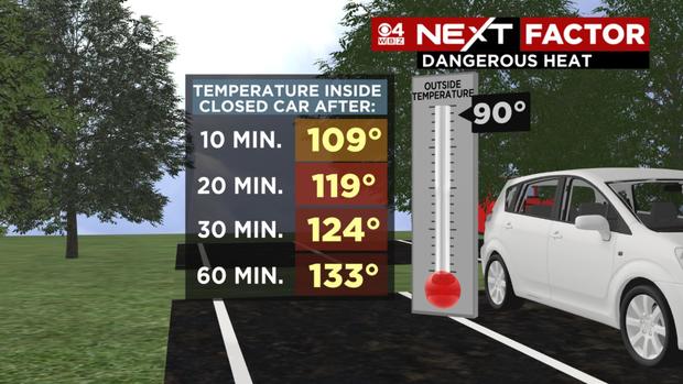
A reminder - it's never a good idea to leave anyone, people or pets, in a locked car in this kind of heat, even for a few minutes.
Once again, relief from the heat can be found along the South Coast, Cape Cod and the Islands. The southwesterly wind direction will keep temperatures in the 60s and 70s much like Saturday.

SUNDAY NIGHT
A cold front will approach from the west. You are likely thinking that given all the heat and humidity we could be in for some raucous thunderstorms. However, at this point it looks like most of us will get a dramatic change in airmass and not even get a drop of rain. There just isn't a lot of support for any severe weather (locally) Sunday night or early Monday. It will certainly remain quite warm for the first half of the night, but you will feel a huge change when you wake up on Monday. Dewpoints will drop into the 40s and temperatures will fall back to more seasonal levels.
NEXT WEEK
Looks a bit more typical of what you would expect in late May. Perhaps a bit above average (in the 70s), through Wednesday with no major weather concerns. We may briefly spike back into the 80s ahead of a cold front and some rain later in the week. As for Memorial Day weekend, no major heat signals right now. Odds favor cooler and perhaps wetter conditions to start and warmer to finish. More to come on that in the days ahead.
Please take the heat this weekend seriously. If you have to be outside, try to stay in the shade as much as possible. Stay hydrated and be sure to check on the elderly and your pets!
For updates all weekend long, stick with WBZ-TV, CBS Boston News and CBSBoston.com