Cold Stretch Begins Second Half Of Winter, February Looks Milder Than Average
BOSTON (CBS) - Time to check your woodpile, make sure there's still some gas in the snowblower, and glance at the calendar to see how long until pitchers and catchers report. We're passing the midway point of winter as daylight increases and average temperatures start the slow climb toward spring and summer.
Of course, we all know that process can take a while in New England. Every year is different though and it's only natural to start wondering what we'll be facing during the second half.
We know that up to this point, it's been a fairly lackluster season. December was one of the warmest on record across New England with barely any snowfall and no lake or pond ice to head out on. January did bring us some snow, though Boston has still only managed three days with snow on the ground so far for the entire season. All of the region remains below average to-date. Winter can be fickle though, coming in fits and spurts. Sometimes it's December that is the hallmark month. Others January, and sometimes nothing happens until very late in February or March. The stats can change rapidly depending on one or two big storms.
Temperatures have been typical for January thus far, but we're about to embark on a very chilly stretch to finish out the month. And it's right on time for the bottom of the annual temperature curve here (technically that's this week, but close enough). I think that if we're going to play catch-up in the cold and snow department, a lot of it will have to happen during this period.
Looking ahead, let's start with the relatively simple stuff. There's no doubt that the coldest stretch of winter will start on Friday and last roughly a week, with a number of days topping out in the 20s. It's not brutal cold, but it will be a period of colder than average weather that is consistent for more than a day or two at a time. Good news for anyone who has been waiting for better ice thickness to try out some pond hockey or to drop a line in the chilly water below. This is all courtesy of a big ridge in the jet stream building up across Alaska and the West Coast, allowing us to tap arctic chill to the north. It will be more than enough to make January the first colder than average winter month for all our local climate sites in years (the last being January 2018).
I think there is reason to believe, given the expected changes in February, that this will prove to be our coldest 7-day stretch for all of Winter 2021-22. So, if you charge through what's left of January, you've made it through the coldest and darkest days of the season.
Now the tougher questions. Will we get a lot of snow out of it? That is a harder one to answer. We have quite a bit to watch, but none of the systems in the pipeline are guaranteed hits.
First up is a band of light snow that should bring a coating to an inch or two to the area on Thursday morning. We've got some ocean-effect snow showers likely on the South Shore to Cape Cod on Friday. Neither are big, but they could add a touch of wintry appeal to the landscape.
Then we have a larger coastal low scooting out to our south on Saturday. At this time, it looks like this will be a miss for us as the pattern is too progressive without blocking to slow it down or draw it north.
Trailing that, there are plenty more disturbances diving down through the trough in the east. A clipper has potential to bring us a mix of snow and rain around Tuesday. But I think the period that may be most interesting is at the end of next week in the closing days of January. This should end up being the point of a regime change in the pattern, and it's often during these transitions that storms get stirred up.
Guaranteed to be a monster? No, there's no way of knowing how the intricate dance between jet streams and upper-level energy will play out more than a few days in advance. But there is at least potential in the pattern and cold air in place, which is more than we have had for most of the winter.
Will the window last? Signs point to a shift starting by early February, resulting in milder conditions returning to the east and colder conditions returning to the west. Let's take a look at some large-scale patterns and what the guidance is showing farther out.
First off, there's the polar vortex. This one is pretty much a slam dunk. It is strong to near-record strong and not much is expected to change in February. There's nothing going on across the hemisphere that's going to significantly disrupt it, so you can bank on it not being too much of a factor during the final month of the season.

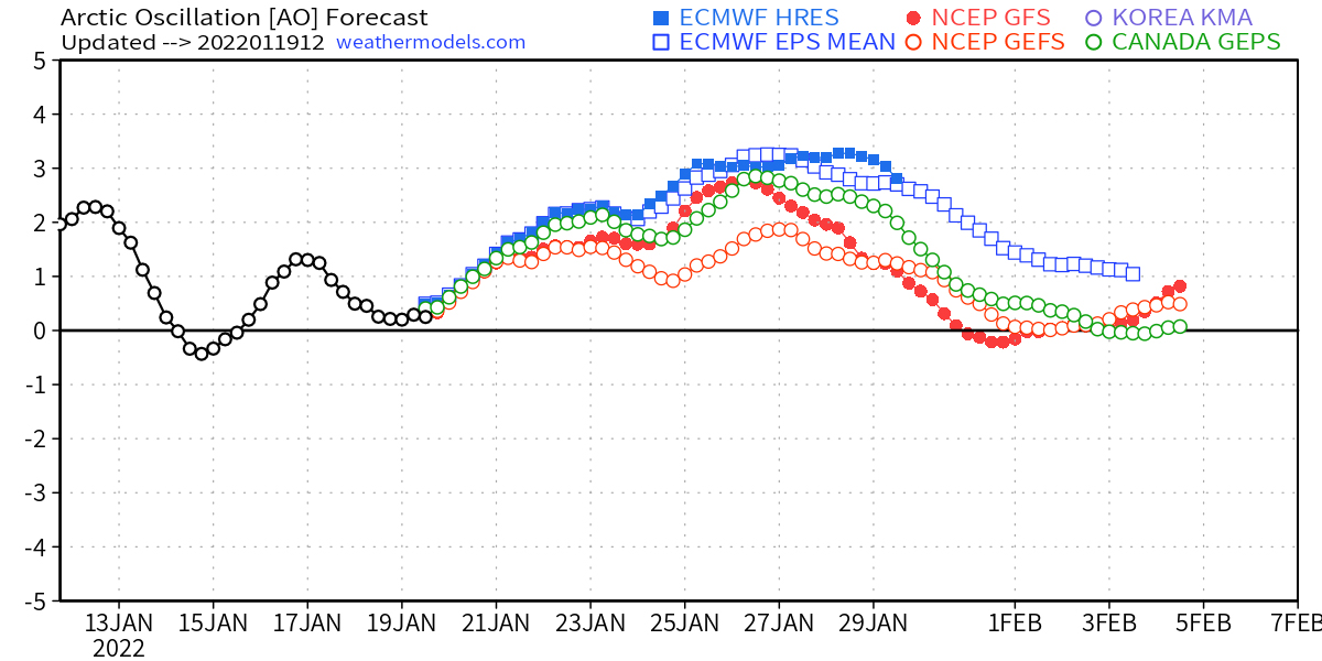
What we're starting to see though is that it will finally attempt to couple to the troposphere. Up to this point, the vortex has been strong but hasn't linked up with the flow through the troposphere where our weather happens (this occurred in 2019-20, which is why we had such a mild winter). That's been good news for winter lovers this January, because it has at least opened the door to snow and cold. But as the final week of January progresses, guidance is pointing to a strong +AO developing. This is the shift to an arctic low setup (instead of an arctic high) that should shut down the consistent cold tap for us next month.
In addition, we're entering a period of generally +NAO (no North Atlantic blocking). That's not too surprising for two reasons. Firstly, it's a state we often see during February when La Nina conditions are present. Secondly, it's indicative of the strong polar vortex taking more control.
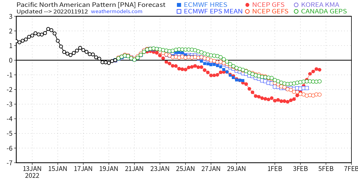
To add on to this, we're also seeing a move to -PNA (trough in the Pacific/west coast). Our best snowstorm chances and cold shots generally occur when there's a ridge in place across the west, not a trough. December was full of -PNA which is great for western snow lovers but not so much on this side of the divide.
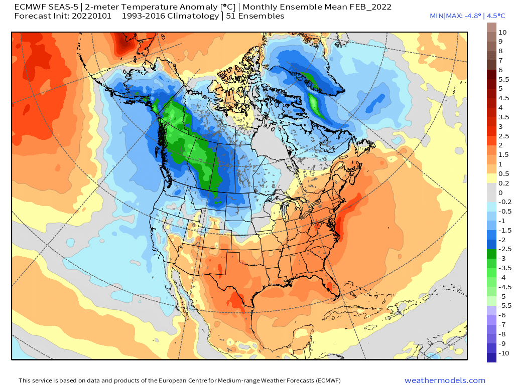
Finally, there's seasonal guidance. I try not to put too much stock in them far in advance (more than a month or so out). But for those curious, they show a mild February in the east and cold returning out west, similar to December.
Putting all this together, how is our WBZ Winter Outlook shaping up? From a temperature perspective, I think we're in good shape. We'll be close to average through December and January, and February looks milder than average. That yields a milder than usual overall winter.
For snow, it's always a bit of a snowball in the dark. A couple big storms can make the whole season. If we maximize the potential in the pattern and get 1 or 2 in the next 10 days, then boom you're set up for an average or above-average winter. If they just happen to slide a few dozen miles too far east or west, then you're left without much. I still feel OK about our below-average call. But ask me again in early February!


