Wind Gusts Across Eastern Mass. Projected To Be 50 MPH Or Higher On Monday Night
BOSTON (CBS) -- The variability and volatility of the weather in Boston really starts to pick up steam in the month of December. As the average temperature starts to drop, and the jet stream starts to become more amplified, there's a noticeable uptick in the frequency of windy days.
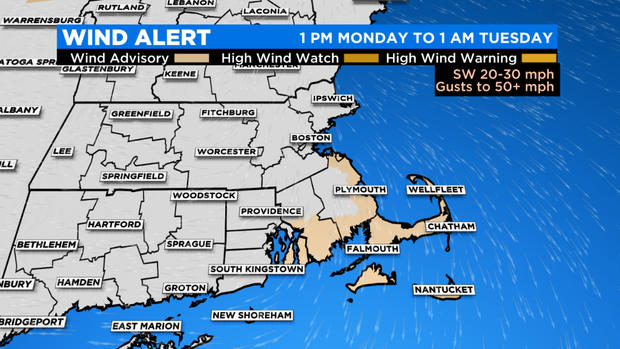
So it should come as no surprise given just how variable and volatile things can be that there is a strong likelihood of high wind gusts in Eastern Massachusetts on Monday. Wind Advisories are in effect for parts of coastal Southeastern Massachusetts, Cape Cod, and the Islands, where the core of the strongest winds will likely be realized.
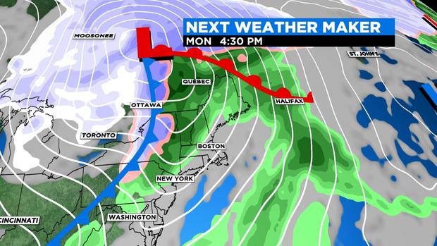
You can blame a large storm system that carves a path across the upper Great Lakes and into the northern reaches of Ontario. That storm will swing a cold front across Western New York on Monday which will then track east into Southern New England by late Monday night.
A batch of showers will impact the morning commute with wet roads and lower visibility. There may even be a rumble of thunder. Then there will be a lull in activity with mostly cloudy skies breaking apart midday into the afternoon, before showers return by the evening and late Monday night.
The timing on this system couldn't be worse for those who may be traveling to Buffalo for the big Patriots Bills matchup Monday evening. The weather conditions for that game will be nothing short of challenging. To those who are traveling there, prepare for 40-50 mph wind gusts that will likely propel waves of lake effect rain snow into Orchard Park along with 30-degree air and wind chills into the 20s at game time.
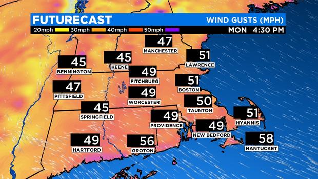
Here in eastern Massachusetts, the strength of Monday's wind gusts will be a function of cloud cover. The less cloud cover there is during the day, the greater the chance that the sun will help mix the atmosphere drawing down to the surface some of the stronger winds aloft that are out ahead of the potent cold front associated with this storm system. This area of stronger wind upstairs in the atmosphere, known as a low-level jet stream, is projected to contain winds capable of producing gusts of 50 mph or greater at the surface in Eastern Massachusetts.
The time frame to watch for the strongest wind gusts on Monday will be between 4 p.m. and 10 p.m. Areas that stand to have the most likely chance of experiencing some of those 50 mph gusts will be over parts of coastal SE Massachusetts, Cape Cod, and the Islands. Wind gusts of this caliber could cause some tree limbs to come down and could also mean isolated power outages.
Showers will accompany the winds that whip through the region late Monday afternoon and evening, but the impact of that rain will be small. This frontal passage will definitely be more remembered for its wind rather than the wet weather it produces, although an isolated thunderstorm cannot be ruled out early in the day.
And whenever there is wind there's an accompanying swing in temperature. There's a good chance that some locales away from the South Coast and the Cape see high temperatures ahead of the cold front into the lower 60s! That will be followed by a steep plunge temperature and a return to a more typical caliber of December chill for Tuesday.
Bottom line: Get ready for some "weather whiplash"!


