Snow Coming To Western Massachusetts, Up To 6 Inches Early Friday
BOSTON (CBS) - Snow in April? Come on now.
I guess we should have known. This spring has been WAY too easy. March and April of 2021 have combined to be one of the sunniest, driest and warmest such periods in our recorded history to this point.
A few notable stats (in Boston) from March 1 – April 13:
- 15th driest on record with only 2006 and 2012 drier since 2000
- 11th warmest on record and warmest since 2012
- Only 3 of the last 29 days have had below average temperatures
- We are currently in our second longest stretch of consecutive dry days this year at 12
- Measurable rain has fallen on just 6 days since the start of March
I could go on and on. Did I mention this past March was also the sunniest ever recorded?
Needless to say, we could actually use some rainfall. The state of Massachusetts is already warning of drought conditions and we have had numerous brush fires across the region.
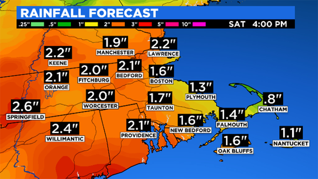
Just in the nick of time, we have a soaker on the way for Thursday night into Friday.
But, the big headlines from this one isn't the 1-to-2 inches of rain or the gusty onshore winds, but instead the threat of snow. This will be a very anomalously cold system for mid-to-late April, although not all that surprising given the current jetstream configuration resembles more of a twisted pretzel than a typical west-to-east flow. For comparison, if this exact system and atmospheric setup had come about a month ago, or certainly in the middle of winter, we would have been measuring the snow in feet!
Before you go cursing the me for telling you to put away the shovels and snow blowers a few weeks ago, let me assure you that unless you live at an elevation above 500-700 feet there isn't much, if any snow in your near future.
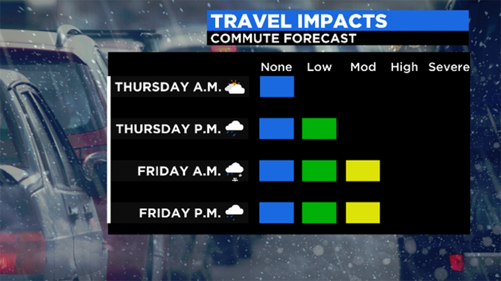
TIMELINE:
Rain arrives from west to east (slowly) Thursday late afternoon and evening. Heaviest and steadiest precipitation occurs overnight Thursday into early Friday.
Also overnight, we will notice a mixing and change to wet snow in the Berkshires, Greens and likely Monadnock region as well. Snow will come down very heavily in these areas overnight perhaps leading to some tree and wire damage from the heavy weight.
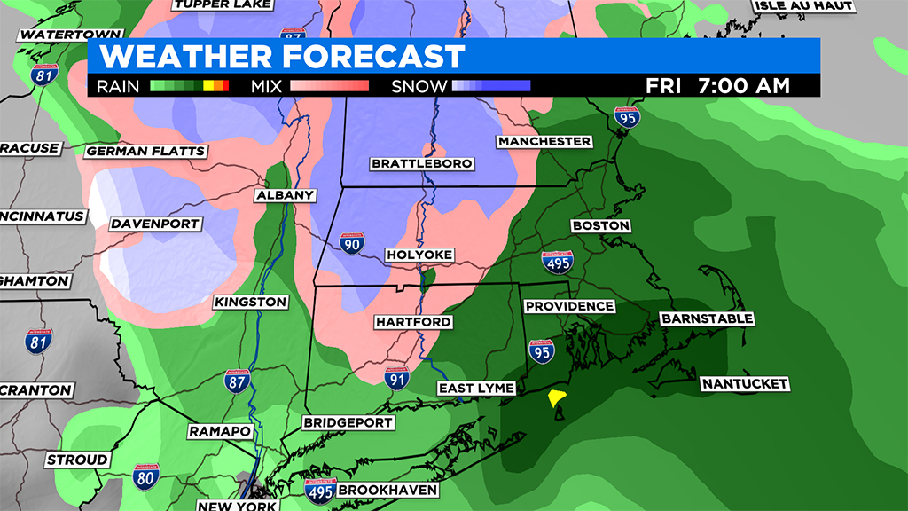
During the day on Friday the rain and snow intensity become much lighter and spottier with a dry slot moving up over southeastern Mass.
By Saturday morning the last of the rain showers will push off the East Coast and we should get some sunshine by the afternoon.
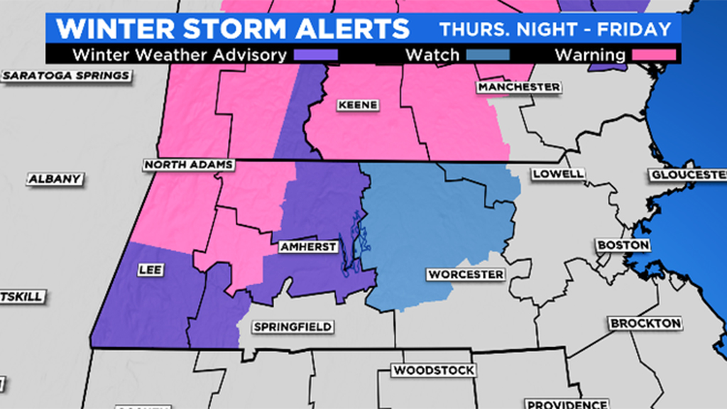
SNOW AMOUNTS:
Coating to an inch: 5-10 miles north and west of Route 495, mainly in northern Worcester County and some of the lower elevations western Mass.
One-to-3 inches: Areas with a bit more elevation including extreme northern Worcester County (at the highest elevations) and also into western Mass. as you gain more than 500 feet of elevation.
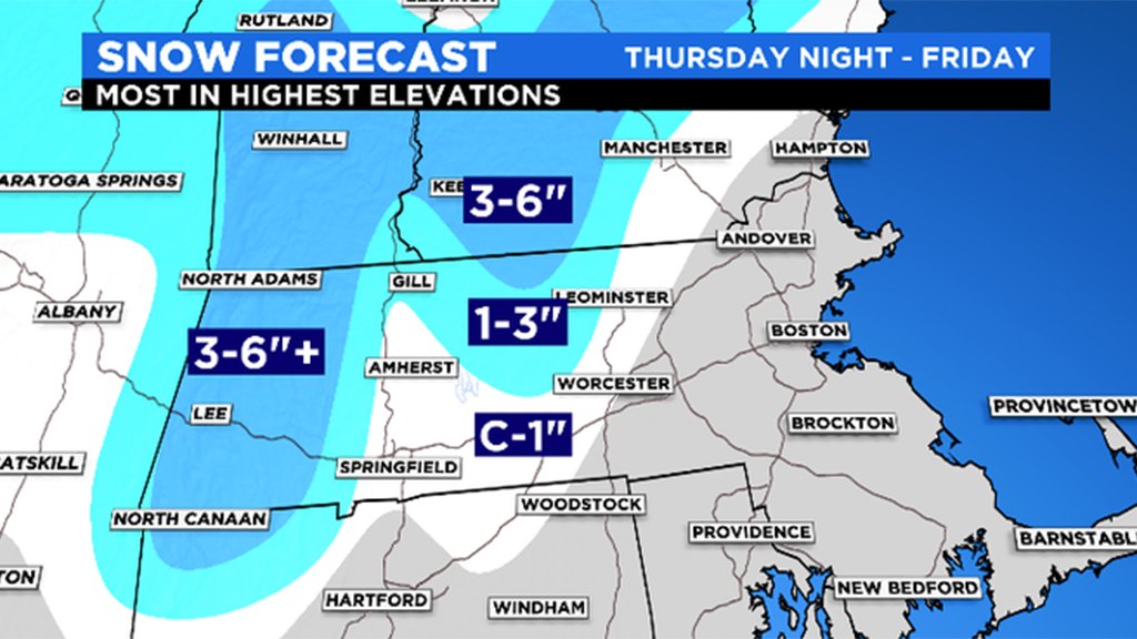
Three-to-6+ inches: The highest peaks of the Berkshires into the Green and White Mountains and perhaps Monadnock region.
WINDS/COAST:
East-Northeast wind gusts between 30-to-50 mph are expected along the coastline late Thursday night into Friday.
These winds will pinwheel northward into the North Shore, New Hampshire and coastal Maine later on Friday as the center of the storm moves over eastern Mass.
Winds veer to the north-northwest Friday night into early Saturday, gusting 20-to-40 mph in eastern Mass. before slowly decreasing during the day Saturday
No big coastal flooding concerns given that the tides are astronomically low.
Stay tuned to WBZ-TV, CBSBoston.com and CBSN Boston for updates leading up to and throughout the storm.
Follow Terry on Twitter @TerryWBZ