Rain, Potentially Damaging Winds Arrive In New England Sunday Afternoon
BOSTON (CBS) - It was a gorgeous start to the last weekend of March. Under bright sunshine, highs climbed into the 60s, with 50s in Boston and the Cape and Islands thanks to a developing sea breeze.
Sadly, the sunshine is in the rearview mirror as a low pressure system and an approaching cold front will bring scattered rain and wind for Sunday.
TIMELINE
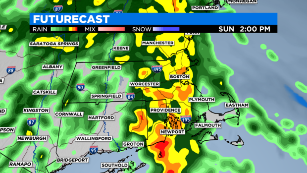
Sunday morning will start off dry with increasing clouds and temps in the low 40s. If you need to take the dog for walk or run any errands, early morning will be your best bet. Scattered rain will develop mid-morning and become widespread by lunchtime.
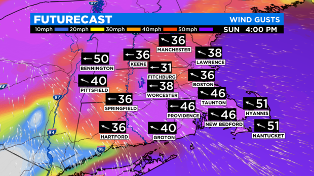
Expect downpours through the afternoon as temperatures climb into the upper 50s by evening. Wind gusts 40-50 mph are likely to develop over southeast New England late Sunday afternoon. There may be a few embedded thunderstorms possible in the evening with the main threats being lightning and damaging wind gusts.
Showers will exit the region from west to east between 10 p.m. to 2 a.m., lingering last over the Cape and Islands.
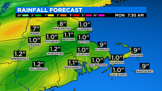
Beneficial rainfall amounts will range from 0.50 to 1.25", isolated higher amounts possible where thunderstorms develop.
Wind is likely going to be the biggest threat with this system. As the afternoon unfolds, a strong low-level jet will try to make for some gusty conditions along the southeast coast, Cape, and Islands. Wind potentially gusting to 45 mph.
While the rain will have come to an end, our attention shifts to the strong to potentially damaging wind threat Sunday night into Monday afternoon. In the wake of the cold front passage, westerly winds may gust 40 to 55 mph, with the strongest gusts Monday morning into the early afternoon.
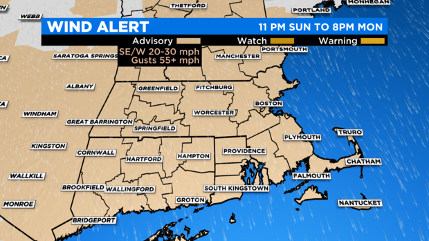
The east side of the Berkshires, the higher elevations of Worcester county and the outer Cape and Cape Ann may experience some of the strongest wind gusts.
Minor tree and powerline damage is possible, leading to isolated to scattered power outages. Winds will wind down a bit by the afternoon, but still gust 25 to 35 mph.
Monday will be bright, but cooler. Highs will only reach the upper 40s, feeling more like the 30s all day because of the wind.

Temperatures do warm up to finish off March with highs in the 60s both Tuesday and Wednesday. Sunshine will fade behind clouds late Wednesday as our next system approaches with rain likely to kick off April.
We'll continue to update timing and rain amounts as new information arrives, so stay tuned!


