'Everything But The Kitchen Sink': Pair Of Storms Headed To Southern New England
BOSTON (CBS) – You've heard the phrase "everything but the kitchen sink." Well that is exactly what we are in for this week with both the Monday-Tuesday storm and Thursday-Friday storm. Snow, sleet, freezing rain, rain - you name it, it will be falling from the sky over southern New England this week.
Up until now this winter has mainly been all about the snow. No real icing events, which can be somewhat common in a La Nina winter (like this one). Since I will be referencing both freezing rain and sleet, I think it is important to be able to distinguish between the two and understand exactly what they mean and why one is much more hazardous than the other.
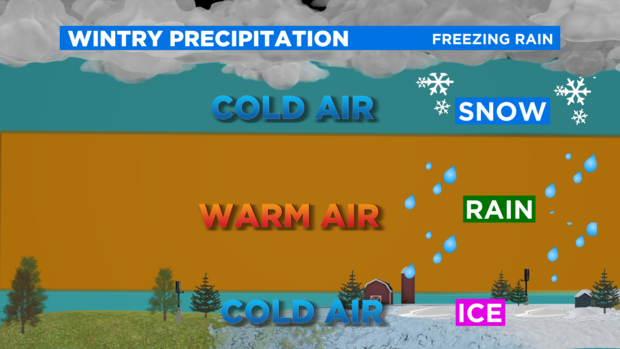
Think of the atmosphere above us a layer cake. When snow is in the forecast, the cake above is all below 32 degrees, simple. Things get much more complicated when temperatures vary in the different layers as you go up.
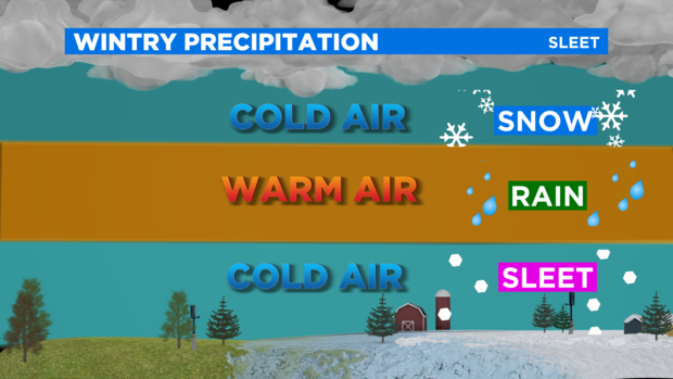
Sleet is formed when you get a fairly sizeable layer where temperatures are above freezing. So, typically you get snow falling from high up in the atmosphere, which then melts to drops as it passes through the warmer layer, and then freezes into little balls of ice (known as sleet) as it falls back into a below freezing layer. Sleet is not nearly as hazardous as freezing rain, as it typically does not adhere to surfaces but just falls and accumulates into a layer of mini ice balls on the ground. You will hear the unmistakable "pinging" of the side of the house and car when sleet is falling.
Freezing rain is one of the most dangerous and hazardous types of precipitation. Freezing rain is formed when a good portion of the atmospheric layer cake is above freezing but temperatures at ground level are below freezing. So, what you get is rain hitting the frozen ground, frozen cars, sidewalks, wires and freezing on contact. When you get a lot of freezing rain it accretes on these surfaces. You can measure this accretion with a ruler. Anything over .10" to .25" really starts to weigh down on limbs and lines and can cause widespread power outages and tree damage. Some of the most destructive storms in our history have come from large amounts of freezing rain.
Ok, so now that we are all on the same page, what can we expect this week?
MONDAY
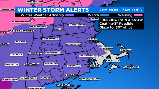
A Winter Weather Advisory is in effect for the areas in purple from 7 p.m. Monday through 7 a.m. Tuesday.
While we wait for the main storm to arrive, some lighter precipitation will begin to fall during the day on Monday. Likely nothing all the noticeable until afternoon, and even then the snow/mix will be light.
Just have to watch for some light icing in some areas by late afternoon and evening, but very little snow accumulation, perhaps a coating to an inch north of the Mass Pike (northern Mass. and southern N.H.).
MONDAY NIGHT
Our actual storm arrives after midnight. With milder air already in place in some layers above the ground, there will be very little snow accumulation in southern New England.
Given this is mainly an ice/rain storm for southern New England, any snow accumulations will be up in central and northern New England. Happy Ski Areas!
TUESDAY MORNING
Latest forecasts have trended much milder with surface temperatures. It now appears that most of southern New England will rise above freezing by 5 a.m. Tuesday with the possible exception of the Worcester Hills and Berkshires (higher elevations).
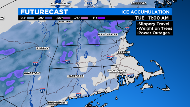
So expect plain rain if you are heading out Tuesday morning. In the elevated areas of Worcester county and western MA, we could see ice accretion up to .25 inches, likely below thresholds for significant ice damage but certainly causing some hazardous travel early Tuesday.
REST OF TUESDAY
The rain and ice taper off by midday and we get clearing in the afternoon. Temperatures fall below freezing overnight, icing up and untreated surfaces
THURSDAY-FRIDAY STORM
Right on the heels of Tuesday morning's mess we get another significant and messy storm to end the week.
I won't go into as much detail yet on this storm given it is still several days away. But here are some bullet points that are a bit different than Tuesday.
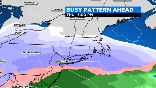
- Looks to start as an initial thump snow everywhere, atmosphere colder to start than Tuesday
- Again, a bit early for amounts but think something on the order of a 3-6" snow thump before we change precipitation types
- Snow timing would be Thursday afternoon and evening
- Overnight we change to sleet and freezing rain (icy mix) from south to north
- By Friday morning, enough warm air has likely moved in to change ice to plain rain across the coastal plain and perhaps as far west as 495
- Rest of Friday features lighter and tapering rain showers. Temperatures could spike well into the 40s in southeastern MA, perhaps hitting 50 degrees near or over Cape Cod.
Neither one of these storms look like big wind producers. The Cape and Islands have the greatest risk of seeing gusts 40-50+ mph both late morning Tuesday and on Friday.
Tides are astronomically low this week, so not expecting coastal flooding to be a big story either.
Clearly there is a lot going on this week. We urge you stay tuned to WBZ-TV, CBSBoston.com and CBSN Boston for frequent updates from our weather team.
Follow Terry on Twitter @TerryWBZ