More Than A Foot Of Heavy Wet Snow Expected In Much Of Massachusetts
BOSTON (CBS) – Gas up the snow blowers, a classic nor'easter is bearing down on southern New England.
This one is going to make some serious headlines, dropping a whole bunch of snow along the eastern seaboard by the time it's over Tuesday.
TIMING
Monday Noon: Moderate, accumulating snow pushes northward. Should be snowing steady everywhere south of the Mass Pike and first light flurries arriving in areas north of Pike in Middlesex, Essex counties
Monday 4 p.m.: Steady snow for most, if not all of Massachusetts, Rhode Island and Connecticut. Heaviest south of the Pike, some areas snowing at 1-2" per hour in parts of CT, R.I. and southeast Mass. First light snow arriving in southern New Hampshire. Winds now starting to get gusty along the South Coast, Cape and Islands.
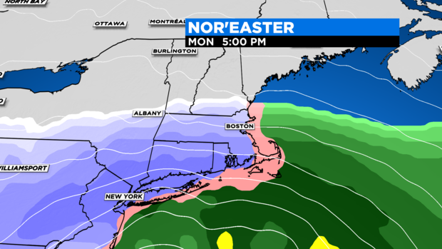
Monday 8 p.m.: Moderate to heavy snow falling across all of southern New England now. Widespread 2-4" of accumulation already on ground. Rain mixing in over Nantucket, Outer Cape Cod. Winds really picking up over SE MA, northeast gusts 25-45 mph.
Midnight: Coastal front setting up along Interstate 95 corridor. Heaviest snow now has pivoted north and west of Boston and I-95 into Middlesex and Worcester counties. Rain mixing in over most of southeast Mass. and temperatures rising along the immediate coastline including Boston where they are on the verge of mixing with rain also.
By midnight there is already widespread 4-8" of accumulation, some areas up to 10". Snow accumulation just about done at immediate coastline and over SE MA. Northeast winds are peaking now with gusts 35-55 mph along the Coastline and over SE MA. 25-45 mph gusts inland.
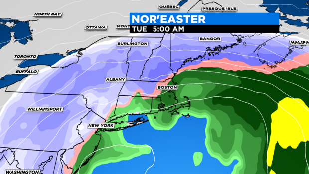
Overnight, through dawn Tuesday: Warm surge of ocean air makes it farthest push inland, coastal front pushed back 5-10 miles from shoreline into Essex and Middlesex counties between 128 and 495. Heaviest snow is also pushed westward into Worcester County and by dawn, shoved even farther north and west into Vermont and New Hampshire.
By dawn, 90-95% of the storm total snow accumulation will be over for southern New England. Widespread 8-14" blanketing a good portion of our area (especially west of I95). Winds are now past their peak and starting to veer more northerly still gusting 25-45 at times. Lastly, the first high tide of concern occurs between 2-3 a.m., causing minor to moderate coastal flooding in the typically prone and vulnerable areas mainly between 1-4 a.m.
Tuesday daytime: After dawn, the precipitation becomes more scattered and light as dry air punches into the storm. Across southern New England on Tuesday morning there will be smatterings of rain, sleet and snow showers.
Very little additional accumulation expected at this point, clean up time! One thing to note, as the storm pulls away, the winds will continue to veer north and northwesterly and temperatures will drop back below freezing in areas that were previously above.
So, by afternoon, any rain showers will turn back to snow showers and untreated surfaces will ice up. Winds will diminish quite a bit as the day rolls on Tuesday, gusts down in the 20s by afternoon. Lastly, one final high tide of concern, between 2-3 p.m. Tuesday afternoon. Expecting mainly minor coastal flooding with this cycle given the winds will be lessening and the wind veering more northerly.
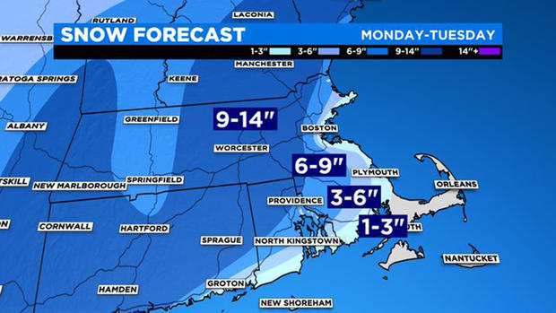
HOW MUCH?
- Coating to 3" for Nantucket and parts of the Outer Cape, all happening in the earliest stages of the storm and eventually washed away
- 3-6" for rest of the Cape, Martha's Vineyard and the South Shore up to Plymouth. Snow down here is very heavy and wet and severely compacted (if not washed away) by rain later in the storm
- 6-9" immediate coastline from Cape Ann, through Boston and down I-95 to Providence. This will be a very heavy, wet snow and also compacted by some rain late in the storm
- 9-14" large swath of southern New England, north and west of I-95. Includes most of Middlesex and Worcester counties and southern New Hampshire. Lighter and fluffier the farther west you go. Heaviest right along or near I-95.
BEGINNING OF A LONG MONTH?
So, the big question, is this a one and done and on to spring or just the beginning of a long month?
With lingering rain and snow showers on Tuesday (Feb. 2), my guess would be that the local groundhogs won't be seeing their shadows, meaning an early spring (if you believe in such things). We will be warming up later this week, with even the possibility of some rain by the weekend.
A sign of milder things to come? Perhaps, but I for one won't be sticking a fork in winter in early February shadow or not.
Follow Terry on Twitter @TerryWBZ


