Parts Of Massachusetts Could Get 10 Inches Of Heavy, Wet Snow Saturday
BOSTON (CBS) - The weather forecast for snow and rain this weekend in southern New England has been a tough one to pin down.
Over the last week or so, models have gone from nothing at all, to a warm and windy rainstorm to a wintry nor'easter and back again. Currently, as of this writing, about 24 hours from the storm's arrival, we still have a range of solutions which is not ideal.
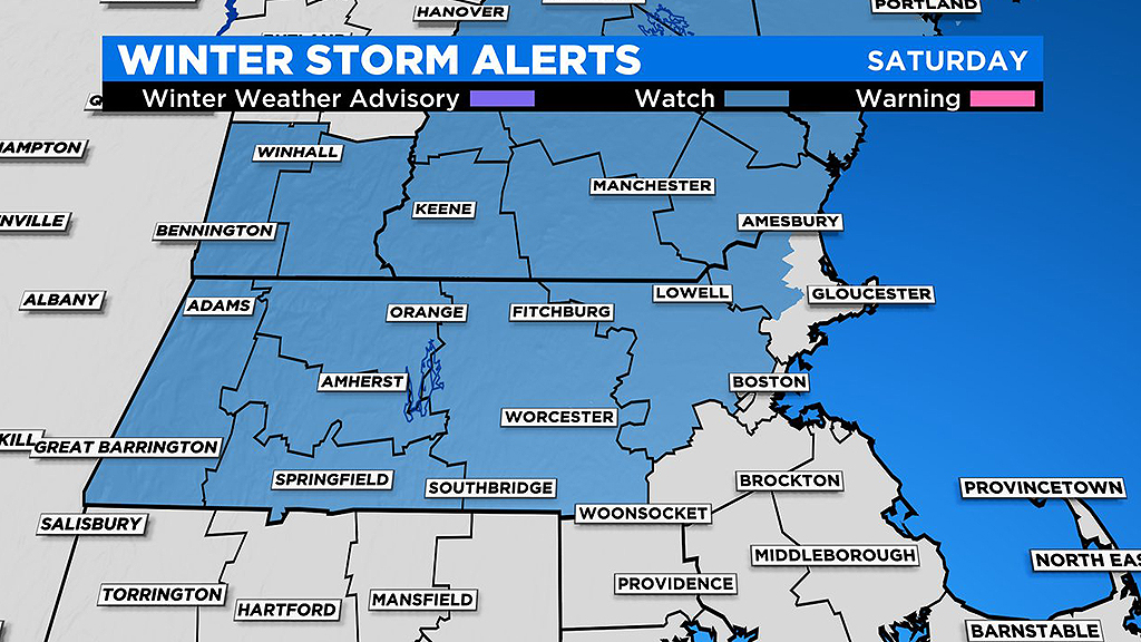
Winter Storm Watches have been posted ahead of this storm. These watches will likely be hoisted to Winter Storm Warnings Friday afternoon, with the likelihood of a foot of snow increasing.
This forecast is trickier than we'd like to have this close to the storm's peak. A wide range of model outputs show loads of snow for central and eastern Massachusetts. While this cannot be ruled out completely, these raw model outputs are neglecting a few items.
First, these model outputs are typically fixed at a 10:1 ratio of 10 inches of snow for every 1 inch of rain. With only marginally supportive temperatures expected for the duration of the storm, the ratio the WBZ-TV weather team is using is closer to 7:1.
Secondly, the ocean is still quite warm, ranging from 45-50 degrees, significantly above average for this time of year.
So, any wind off the water (which of course applies in a nor'easter) is going to flood the shoreline with mild air.
Also, there really isn't any significant source of cold air around. Most times, in order to get a big snowstorm in our area, you need a high-pressure area to our north to pump the cold, Canadian air southward. That simply does not exist this go-around, therefore the storm will need to produce its own cold air by drawing it from upper levels of the atmosphere. It will have to snow at a really hard clip for that to happen, but it's possible!
Simple right? Ha!
Let's get down to the nitty gritty as best we can.
TIMELINE:
Some rain showers arrive Friday afternoon and evening, not all that heavy. Showers continue off and on Friday night into Saturday morning.
Between 7 a.m. and noon on Saturday, the storm starts to deepen south of Long Island and the precipitation should begin to fill in and increase in intensity.
If there is to be a "peak" of this storm, it will come Saturday afternoon and evening. This is clearly the time frame to watch. With the right storm track and intensity, we would see heavy, wet snow falling in most of central Massachusetts early Saturday afternoon.
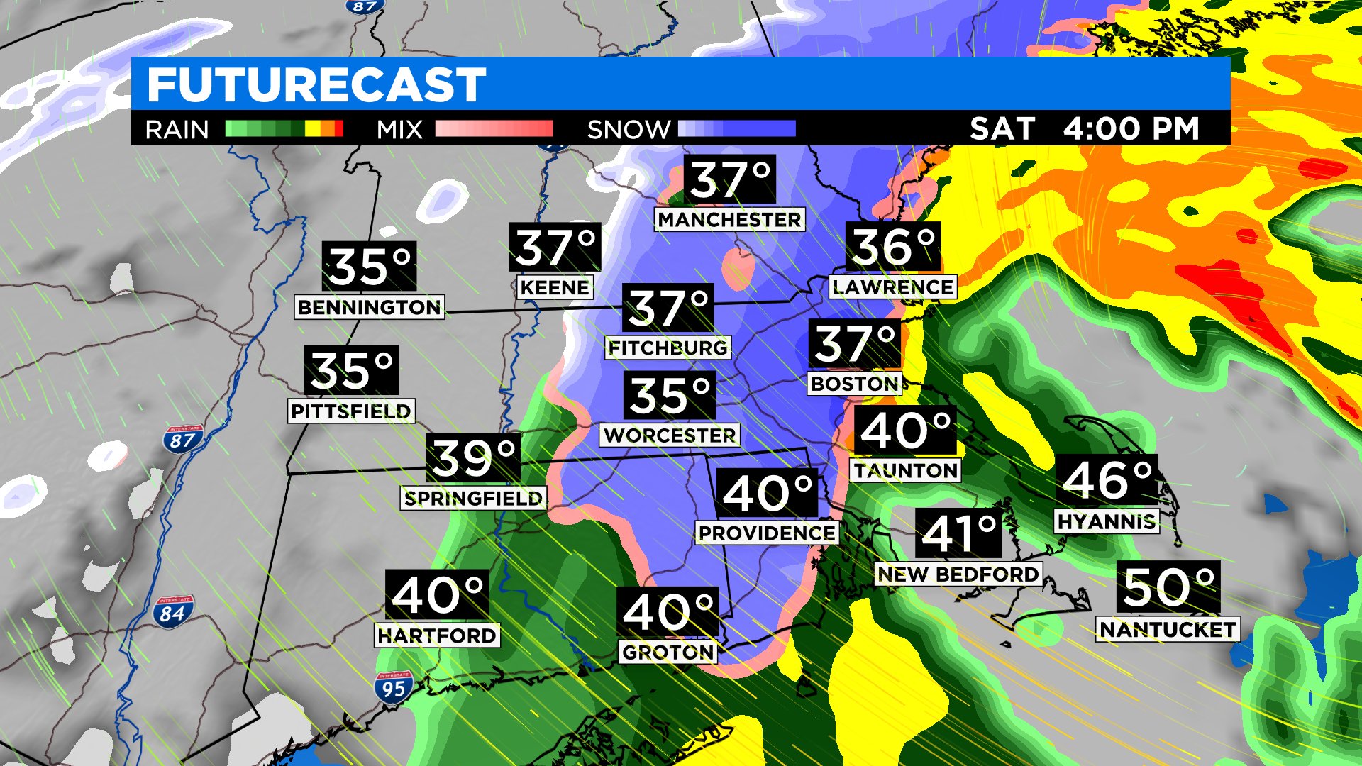
The rain/snow line would likely collapse to the east to some degree later in the afternoon, changing the rain to a wet, pasty snow closer to 128 and into Metrowest.
HOW MUCH:
This is a forecast that has only moderate confidence because of the multiple moving pieces, but here it goes.
A solid thump of snow for Worcester County into Middlesex County and into southern New Hampshire could deliver 10"+ of snow. It's possible with some mesoscale banding that the snow falls at a rate of 1-to-2" per hour.
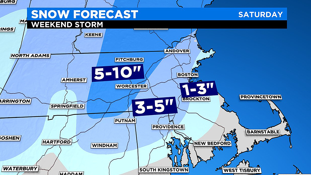
As you get closer to 495 and 128, the amounts trail off to 3-to-5 inches. The South Shore and northern Bristol and Plymouth counties will likely get mostly rain with some light coatings mixing in.
If areas were to get 10"+ of this pasty snow, scattered power outages would certainly be possible.
WINDS:
High Wind Watches are in effect for the South Shore, Cape, and Islands.
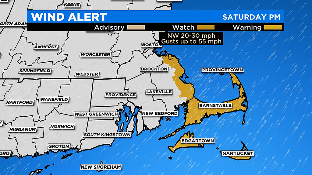
As the storm departs the area, strong wind from the west could crank to 55+ mph. Scattered power outages possible with these type of wind gusts.
COASTAL FLOODING:
Tides will be astronomically low, so not expecting any significant coastal flooding issues. High tides occur around 2 p.m. Saturday and 3 a.m. Sunday, slightly before and after the peak of the winds.
As always, we urge that you stay tuned to updates before and during the storm on WBZ-TV, CBSBoston.com and CBSN Boston - we've got you covered!