Winter Weather Outlook: Less Snow, Warmer Than Average WBZ Weather Team Predicts
BOSTON (CBS) - Okay let's be honest. Last year, our winter outlook got roasted. Literally and figuratively. We tried to read the tea leaves and called for a very snowy winter. The result was one of the warmest and most boring winters in the history of southern New England. When it comes to these long-range outlooks, prognosticators can win some and lose some. But in the end, nature still holds all the cards. We did a post-mortem on where it all went wrong here.
Bottom line is that the 7-day is usually on solid ground. But figuring out the sensible weather 2-to-3 months in advance is, as you might imagine, a work in progress. You can find all sorts of outlooks and opinions from the private sector to government meteorology outlets. No one is going to be right every time. What we can do is learn from failure and continue to make progress toward reliability!
So here we go! Winter 2020-21. Could it possibly be a lackluster season for the third year in a row? The early signs, believe it or not, say yes. Here's a rundown of all the factors we keep tabs on and how they're working to shape the next several months.
Elephant in the room: La Nina
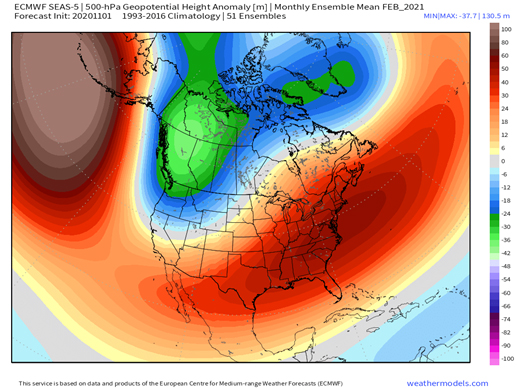
A good starting point in any winter outlook is a peek at what the El Nino Southern Oscillation (ENSO) is doing. While El Nino is a warming of the equatorial Pacific, La Nina is a cooling of those waters. Many of our snowiest seasons occur when the ENSO signal is weak or neutral, while strong events on either side of the spectrum tend to feature less snowy outcomes. This winter firmly stands in the La Nina column with a moderate to strong event expected to linger into the next few months.

A prominent feature during La Nina is a ridge across the subtropical Atlantic, which pokes up into the southeastern U.S. and sometimes northward through New England. The strength of that southeast ridge is typically greatest during January and February. Think back to the last La Nina in 2017-18 when we had the warmest February on record. If there's some North Atlantic blocking to push back on that ridge, then it could be flatter with cooler air holding on across New England. Though at this time, it looks like that will not be the case.
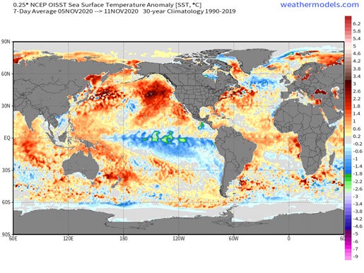
Normally we also look at the broader view of the Pacific for analogs, but this year it is impossible. There are no good analogs. None. Almost every case of La Nina features colder waters extending into the North Pacific, among other global changes. This time around the North Pacific is running way above the norm, as is the Atlantic. You can look back through all the ocean archives and not find a situation close to this. So that won't be particularly helpful to us.
The "October Snow Curse" and "November Bellwether" Tandem
Is the October snow curse a real thing? It depends on how you look at it. If you count all sorts of "trace" snow events during October, then you won't find any strong signal. But if you just look at the big/truly unusual ones, then yes you could say very early snow curses the rest of winter. Our biggest October snow events locally were this year, 2011, and 1979. After the major "Snowtober" storm in 2011, it basically never snowed again for the rest of the winter. In the 1979-80 campaign it was barely any better with 12.5" for the season. Boston also had some measurable October snow in 2005 and 2009 and neither of those winters were particularly noteworthy, either.
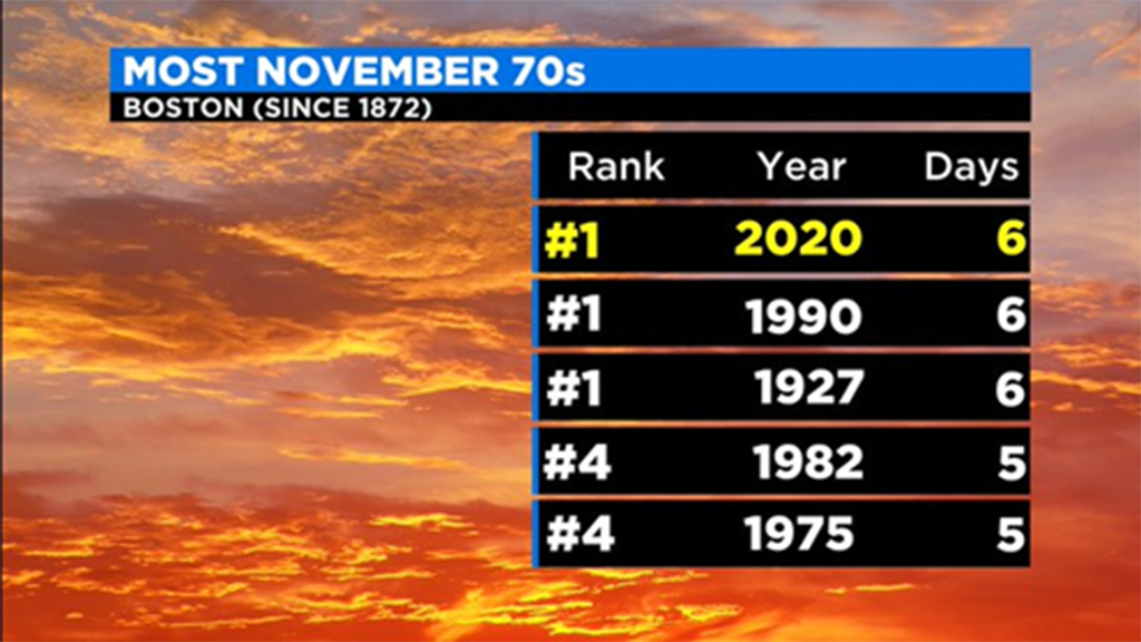
As for November - it frequently shows winter's hand. Last year was one of the only years we've ever seen where that bellwether rule failed. Sure it was cold and snowy right off the bat in late November-early December, but that ended up being the entire winter show. Often a mild November leads to a mild winter and vice versa. For sure, this November will go in the books as milder than average thanks to record warmth during the first half of the month. We are tied for most 70F days on record in Boston with 1990 and 1927...both of which were also meager winters with 19.1" and 20.8" respectively.
Computer Guidance In Strong Agreement
"All models are wrong, some are useful." This certainly applies to weather. The seasonal models aren't gospel but they can give us some clues. They actually did a pretty good job last winter and we ignored them, much to our chagrin. So what are they saying? All the seasonal models out there are hitting the La Nina setup hard. That means a pattern that favors the coldest conditions hitting Alaska, western Canada, and northwestern sections of the Lower 48. Meanwhile a lot of strong southeast ridge developing, keeping the rest of the country quite mild.
They're also really pushing a +NAO and +AO tandem. In other words, very little North Atlantic blocking (particularly in January and February) and a strong polar jet stream. These are factors that make it difficult to sustain and periods of major cold in the eastern U.S. and it's also exactly what happened last winter.
The Polar Vortex! Everyone's Favorite
What's up with our high-altitude friend to the north? It's off to a rip-roaring start and healthier than average as we head toward December. It may be counter-intuitive, but a stronger polar vortex up in the stratosphere means fewer chances for arctic cold to invade. Last winter featured a very strong polar vortex. Where snow and cold lovers really get into trouble is when the stratospheric vortex couples to the troposphere, where we live and our weather takes place. This also happened last winter, and the result is a strong jet stream that doesn't take big dips allowing for frigid outbreaks and larger storms.
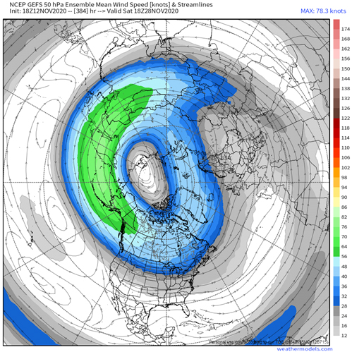
A problem with the polar vortex is you can't really predict it more than 2-3 weeks in advance. You can try to find clues as to whether a pattern will push it off the North Pole or throw punches of energy flux at it to "weaken" or "split" the vortex, but that's about it. So while we can say with good confidence it will start out strong and that's not a great look for snowstorms, it may not hold all winter. Some research shows that during La Nina events, disruptions are more likely toward the tail end of winter.

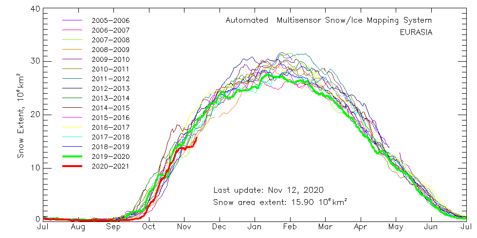
The Autumn Run-up of Eurasian Snow Cover
This variable has received quite a bit of attention in recent years, though I'm not sure I am on board with it being a big factor. The general running theory was that a quick build-up of snow across Eurasia in October can produce stronger areas of high pressure in that region, which help to favor weakening of the polar vortex and severe winter weather in the eastern U.S. and Europe. For a few years it looked like this was a pretty noteworthy relationship, but in recent times it has failed the test.
So I'm including it just for the sake of argument, but it too points toward a fairly docile winter. The run-up has been one of the lowest on record over the past 15 years or so. Another check in the "not harsh" box for us.
In Conclusion....
You've probably gotten the gist by now, but all signs are pointing to a mild winter. Doesn't mean nature won't dunk on us and bury us in snow anyway, but there's no way you could make a case for a very cold and snowy winter with the variables on the table here in November. And honestly, we never even bother forecasting a colder than average winter unless the signs are glaring, because climate change continues to make our winters milder. 13 of the last 15 winter months have been warmer than average in the Boston area, including 7 straight. This 5-year period includes the warmest December on record, the 3rd warmest January, the 1st, 3rd and 7th warmest Februarys, plus the 1st, 4th, and 5th warmest winter seasons. You can still get a crazy one-off winter like 2014-15 (which we did call to be snowier and colder than average!), but that's going to be the exception rather than the rule. And the signs were strong that year to indicate it was on the table.
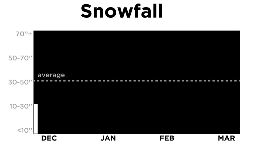
Snow is a trickier variable, because 1 or 2 good storms happening anytime over 5 months could immediately get us close to average for the season. It's almost a guessing game to know if a run of good storm track will sneak into the pattern at some point through February. But the general rule is that a warmer winter with +AO/+NAO as dominant features will produce less snow. So we will be calling for below average snowfall as well.
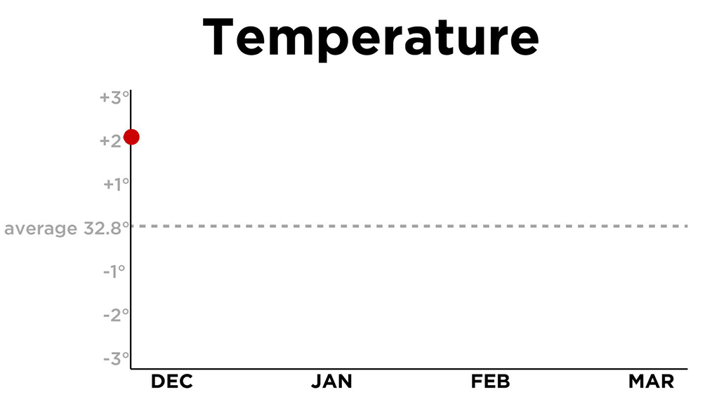
To showcase our forecast this season, we're adopting a different kind of look. Similar to polling tracking, we will start out with a projection of how much warmer than average this winter will be, and how much snow will fall. Every 2-3 weeks we will update the tracking based on what is actually occurring and how guidance shifts over time. This way, at the end of the cold season, we will have a graphical story to tell! It will show how we felt things would play out in the beginning, and when (if at all) the thinking changed.
We'll kick it off with a projection of winter (December-January-February) ending up 2-3F warmer than average and snowfall in the 15-30" range at Boston's Logan Airport. And we'll track it right through the end. See you on the other side!