Light Snow Possible In Many Parts Of Massachusetts Friday
BOSTON (CBS) - No matter how long you've lived in New England it is always a bit jarring the first time you hear that four letter word. Typically, it comes first in November, but once in a while (and seemingly more frequent in recent years) we get it first in October.
SNOW.
Love it or hate it, it is part of the fabric in New England. Just when you are getting over the last warm days at the beach, in the blink of an eye you are spending your weekends bagging leaves and digging the snow shovels out of hibernation. It is almost like a rite of passage, draining the last bits of gas out of the lawn mower and giving the snow blower a test, hoping it still has life for another winter. If you haven't done it yet, you will, it's coming.
No, I am not trying to hype up this storm on Friday. This is not going to be another "snow-maggedon" or "Snow-tober." But I am getting a serious case of deja-vu, almost like I have written this exact same article about snow coming around Halloween before.
It turns out, I have!
Looking back at snowfall records in Boston (going back to 1872), snow has accumulated 3 times in the month of October. All three occasions have been in the last 15 years, including the notorious Snow-tober back in 2011. Our planet may be warming, but apparently October hasn't gotten the message!

Surely, an early season snowfall must mean we are in for a big snow year right?
WRONG!
In fact, it is the kiss of death in Boston. All three occasions in which we have had accumulating snow in Boston in October have been followed by below average snowfall seasons. This includes 2011 in which Boston received a paltry 9.3 inches of snow that winter (also was a La Nina winter, like this one... hmmmm.)
At this point I would say that an actual snow accumulation in Boston is rather unlikely on Friday. So how about Worcester?
Chances are much higher for some measured snowfall in Worcester, so let's take a peek at what an October snow may mean for the following winter there.
Same idea.
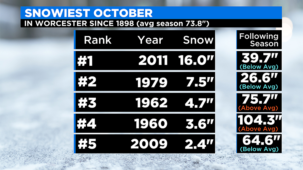
Take the top 5 snowiest Octobers in Worcester and three of them had below average snow seasons to follow, including the most recent years of 2009 and 2011 (which was below average by nearly 34").
Ok, let's not get carried away with the numbers. How about we re-focus on the here and now. What exactly are we looking at on Friday?
Interestingly enough, our storm is actually partially from the remnants of Hurricane Zeta! Hurricane turned snowstorm? That sounds like the plot for another terrible weather disaster movie. Strange but true! Zeta is forecast to make landfall in southern Louisiana as a minimal hurricane Wednesday evening. From there it will move quickly up the Appalachians, off the Mid-Atlantic coastline and slide to our south, fairly close to the "benchmark" for many of our winter storms (40N 70W).
Had this storm come in the middle of winter, it would undoubtedly be a whopper.
However, there are several limiting factors for snow accumulation in late October. The unfrozen ground and still relatively mild ocean make it very difficult this time of year for any real accumulation in eastern Mass.
You almost always need some elevation help, so we look to the Worcester Hills, Berkshires and Mountains of northern New England most frequently.
TIMELINE:
Rain will arrive Thursday afternoon from south to north across southern New England. The rain will become steady and heavy at times and continue through the night. After midnight, colder air starts to filter in and change the rain to a wet snow. This occurs first in areas in southern Vermont, southwest New Hampshire and in elevated areas of central and western Massachusetts.
This is largely a southern New England storm, so the northern mountains (ski areas) will have to wait a bit longer. As more and more cold air filters in, gradually we expect the rain to mix with and in some cases change to all snow for the remainder of southern New England, right to the coastline (with the likely exception of the South Coast, Cape and Islands). This changeover will be happening early Friday morning, so many of you will likely wake up Friday and see your first flakes of the season!
By late morning and midday, the storm system is pulling away and the mix/snow will taper off.
HOW MUCH:
Still a bit early for numbers here, we typically like to wait until we are about 48 hours out from a storm. But, given the time of year and limiting snow accumulation factors, I don't think we will see much more than scattered coatings on the grass in eastern MA

Best chance for a few inches of accumulation would be in those elevated areas I mentioned earlier. Again, stay tuned for a more precise forecast in the next 24 hours.
WIND:
This will be a nor'easter type event here, so areas along the immediate coastline will get some gusty east-northeast winds. Late Thursday into early Friday winds will likely gust 35-55 mph at the shore, strongest down on the Cape and Islands.
TIDES/COASTAL ISSUES:
There is a full moon coming up Saturday, but tides will not be all that high (astronomically) when the storm comes through. Have to watch the Thursday night high tide at 11:02 p.m .(Boston height 9.5') for some minor issues, but that's about it.
WHAT'S NEXT:
Big weekend ahead for those that enjoy cold and darkness. The coldest airmass of the season arrives here Friday into Saturday.
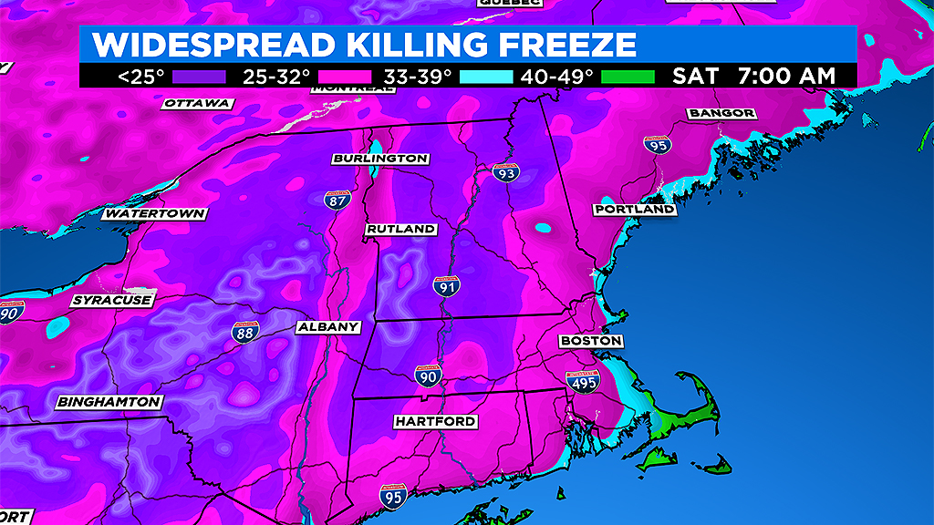
It will be a widespread killing freeze for just about everyone. Very chilly for trick or treating Saturday evening, temperatures starting in the low 40s and dropping into the 30s, thankfully dry with very little wind.

And then, to top it all off, we turn the clocks back Sunday at 2 a.m. Our sunset on Sunday will be at 4:37 p.m. Ugh. We are in for a serious shock to the system and a season changing couple of days.


