Heavy Rain, Damaging Winds Possible During 'Raucous' Night In New England
BOSTON (CBS) – After an exceedingly dry and quiet stretch of weather, we finally have some much needed rainfall headed our way.
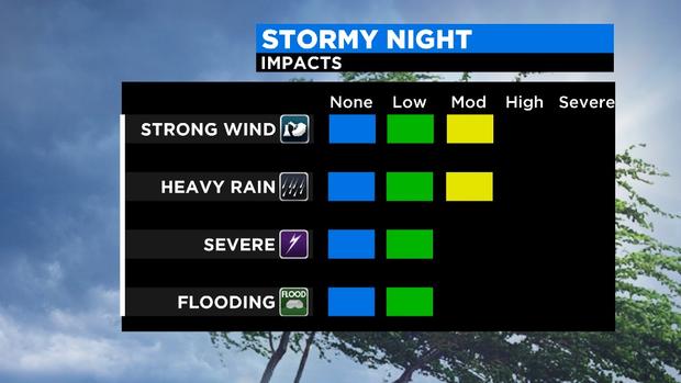
It could be a fairly raucous night for some with periods of heavy rain and potentially damaging wind gusts.
This is all in response to an area of rapidly deepening low pressure which will be passing through New England late Tuesday and early on Wednesday. In fact, we could even reach "bombogenesis," a term used when a low pressure system deepens at least 24 millibars in 24 hours.
TIMELINE
An area of rain arrives around or just after midnight tonight. Intensity of rainfall will vary through the early morning hours of Wednesday.
There may be a fine line of downpours and strong winds which develops and pushes through central and eastern MA between 6-9am. Thereafter, rain and wind taper and sunshine develops for midday and afternoon on Wednesday.
RAINFALL
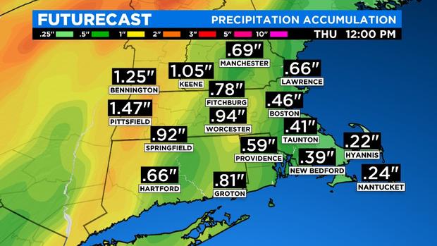
Clearly we need every drop we can get with deficits running as high as 10" or more in parts of our area since January 1. While tonight's rain won't be a drought buster, we can finally put a bit of a dent in our severe drought.
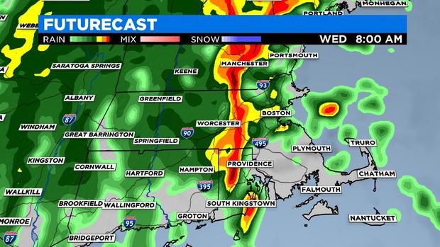
Totals will range from about a quarter of an inch (Cape Cod & Islands) to as much as 1-2" (most likely in portions of Western MA). Amounts will be very variable and dependent upon where the heavier bands form, but there is clearly a higher risk of spot flooding the farther west you live in Massachusetts.
WIND
Winds will be screaming just above ground level tonight. The biggest question is whether some of those strong winds can be drawn down to the surface. Best chance of this happening would be within any heavy bands of rain.
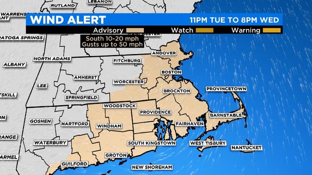
It appears there may be a skinny band of downpours between 6-9am on Wednesday, within that band lies the greatest threat of damaging winds, perhaps gusting to 50 mph (out of the south). Given that most trees are still fully leaved, the wind damage threat is a bit higher (leaves work as sails, catching the wind and potentially bringing down some limbs/trees).
Again, the wind and rain will quickly exit our area late Wednesday morning and make way for a fairly pleasant afternoon.
Follow Terry on Twitter @TerryWBZ