Boston Weather: Prepare For A Cold Mother's Day Weekend
BOSTON (CBS) - Many areas will enjoy dry conditions with a mix of sun and clouds Thursday. We can't rule out a pop-up shower in the afternoon and early evening, but activity will be hit or miss and chances are low. Temperatures will range from the 50's across Cape Cod and the coast to the lower 60's inland. Seasonable for this time of the year so enjoy!
A weak front will pass through the region Thursday night. While moisture will be limited, a few showers are possible along with a wind shift from the southwest to the west. Skies will average partly cloudy with lows in the upper 30's to low to mid 40's.
This passing front will create large swells over the ocean. Tides will also be running astronomically high Thursday night due to the Full 'Flower' Moon, so there is a coastal flood advisory in effect from 8 p.m. until 3 a.m. Friday. Portions of eastern Mass. could see minor coastal flooding. Typical low-lying areas near the shore that are prone to flooding may see one-to-two feet of inundation.
NEXT STORM THREAT
Friday will be another mainly dry day with increasing clouds and highs near 60. An arctic wave of low pressure will approach the area late in the day.
This system is likely to bring mainly rain to the area Friday night which will changeover to a period of snow for parts of the area, especially higher elevations where minor accumulations are possible.
Patchy coatings are possible west and north of I-495 up to a couple of inches across the higher terrain of north-central and western Mass. into Vermont and New Hampshire.
Clearly, this late in the season, the highest chances of accumulating snow occur during the overnight period and at higher elevations. So has it ever snowed this late in the season? Looking back, the latest measurable snowfall in Boston was on May 10, 1977 when 0.5" of snow was recorded.
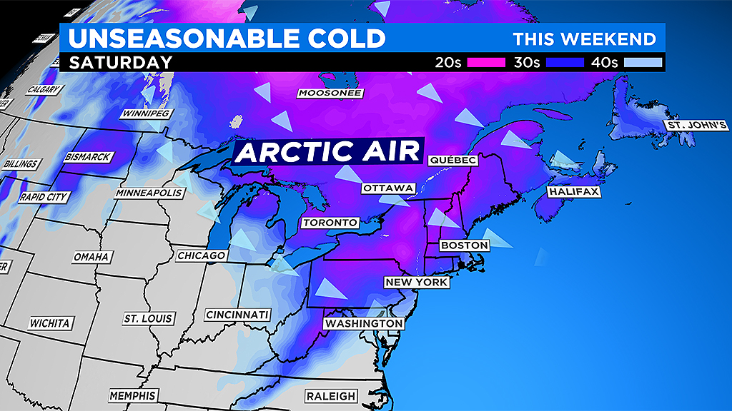
Low pressure will deepen on Saturday through the Gulf of Maine as it pulls away, but gusty northwest winds will continue to draw in cold air.
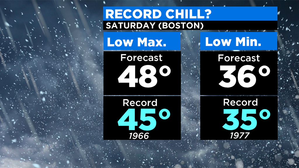
Saturday will feature scattered showers, blustery conditions and near record cold. In fact, the record low minimum temperature in Boston for the date is 35 degrees set back in 1977, while the record low maximum temperature is 45 degrees set back in 1966.
Temperatures will start off in the 30's and struggle to get out of the 40's in many areas. Winds will gust 35 to 45 mph at times, so it will only feel like the 20's and 30's. It will feel more like March than May.
We will clear out Saturday night, but the chill will remain.
If winds completely die out, temperatures would fall quickly, but with an active wind that actually may help temperatures stay above record low territory. Still, near record lows are possible in Boston and Worcester Sunday morning as temperatures will be in the 30's.
The record low in Boston is 34 degrees set back in 1902, while the record low in Worcester is 30 degrees set back in 1966.
Expect dry conditions on Mother's Day as temperatures moderate, but highs will be running below normal in the 50's.
Typically the final frost of the season across eastern Mass. occurs late April and early May, but I'd hold off planting until after this weekend as some areas could still be dealing with near freezing conditions during the overnight periods. While cooler than average temperatures continue into early next week, it does look like temperatures to recover back to near normal standards later in the week.


