Boston Weather: Cool Finish To Week And A Chance Of Snow
BOSTON (CBS) - There was a little taste of winter Thursday morning with scattered flurries and snow showers.
Some areas north and west of Boston saw coatings on decks and grassy surfaces. Higher elevations in central and northern Massachusetts even saw more than an inch of snow. There was no impact to roads, but visibility did drop in spots when showers pushed through.
There also have been some breaks of sunshine as well. This quick moving disturbance will push out of the area by mid to late-morning, leading to improvements by midday into the afternoon. Can't rule out an isolated shower, but expect a blend of clouds and sun with mainly dry conditions. It will be another cool day with highs mainly in the mid 40's to near 50 degrees. Since temperatures will climb above freezing, any snow that did accumulate will likely melt away.
Partly to mainly clear skies are expected tonight as high pressure takes control. It will be chilly with temps falling back to near freezing. Lows will be about 10 degrees below normal for mid-April.
Cool Finish To The Week
It will stay cooler than average to finish off the week with highs a few degrees warmer than Thursday, but still 5-10 degrees below normal. Friday will be mostly dry with the best of any sunshine early in the day. Expect increasing clouds through the afternoon with chances of precipitation returning Friday night into Saturday as low pressure passes to our south.
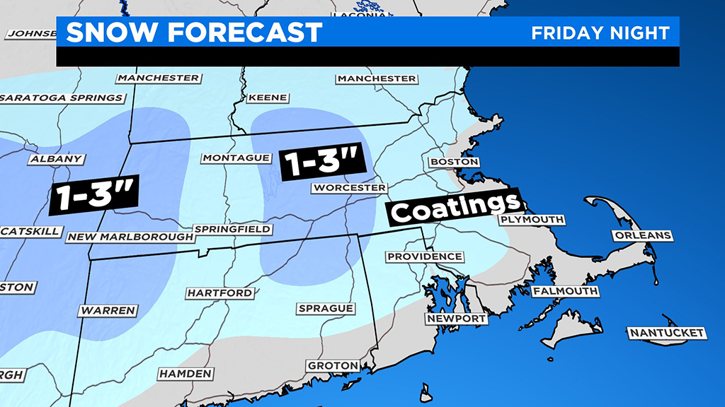
More Snow Chances Into The Weekend
Confidence is building that a wintry mix of rain and snow is likely to move in Friday night, with areas north and west of Interstate 95 seeing a thump of snow overnight. Tricky accumulation forecast, as temperatures will remain warm enough south and east to remain just rain, but I wouldn't be surprised to see some wet snow mixed in at times.
We'll continue to see a wintry mix early Saturday before a transition to scattered rain showers and eventually clearing later in the day. It will remain cool, in the 40's on Saturday.
Slushy coatings are possible away from the coast with 1-3 inches of snow possible inland, especially across the higher terrain. Temperatures will be coldest at higher elevations and that will likely play a role in accumulation, especially north and west of I-495.
While the Boston area doesn't typically see much snow mid-to-late April, it can happen.
For the month, we average about 1.9" of snow, but getting measurable snow on the back end of the month has only happened 16 times since records began in 1872. The last occurrence was April 17-18, 2014 when Boston picked up 0.3" of snow. If we were to get an inch of snow in Boston this late in the season, it would be the first time since 1987, when the city saw 4.1" on April 29-30th.
The one thing about April snow, it quickly melts. We should see a warm up on Sunday as temps rebound back into the upper 50's to near 60 degrees. Right now, Sunday looks to be the pick of the weekend with more sunshine and warmer temperatures.