Boston Weather: Snow Moves Out, More Rain On The Way
BOSTON (CBS) - Boston picked up a trace of snow before changing over to rain Monday. Many areas received 1-2 inches of rain, with locally higher amounts. Worcester picked up 4.2 inches of snow, which is a record for the date. The previous record was 4.1 inches set back in 1992.
High pressure will briefly build in today into tomorrow, before another coastal storm will pass south of the area on Wednesday. The latest track of this next storm has shifted south, so right now the best chances of mainly rain will be south of Boston and along the coast.
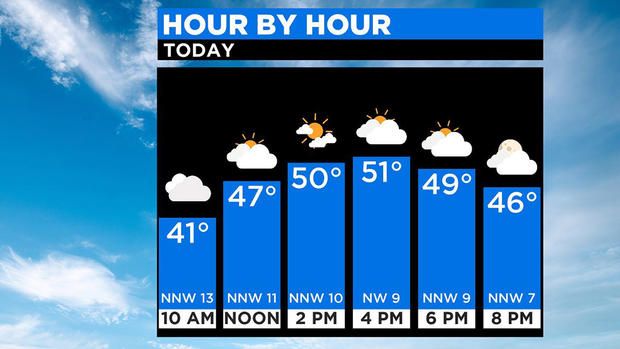
TODAY
Skies will generally remain mostly cloudy with sunny breaks developing throughout the day. A north to northwest wind will average 5-15 mph. Temperatures will greatly improve, climbing from the 30s this morning through the 40s this afternoon. Some spots will near 50 degrees.
NEXT 24 HOURS
Skies will remain partly to mostly cloudy overnight, as temperatures fall back into the 30s. Areas north and west with the recent snowpack may fall back into the mid to upper 20s. Light northwest winds will turn northeast after midnight.
It will be slightly cooler on Wednesday with an onshore wind. Highs will be in the mid to upper 40s, coolest at the coast and areas north and west of 495. Most of the day will be dry. A coastal low will approach the area increasing the clouds through the day, but also bring the risk of a few showers by the afternoon and evening to areas south of the MA Pike. Can't rule out a few showers north, but generally any precipitation will be light. The risk of showers over southeastern MA will continue overnight into early Thursday. Up to .25" of rain is possible over Cape Cod and the Islands, with decreasing amounts to the north.
LATE WEEK
As showers exit early Thursday, expect improvements through the day. Dry weather and light winds are expected with highs in the upper 40s. Friday will be a bit warmer with temps in the 50s. We'll find a mix of clouds and sun as a disturbance passes to our north and south, so we are caught in the middle. We may see a passing shower, but the threat remains low right now.
WEEKEND
Saturday will be the pick of the weekend with a better bet of sunshine as widespread rain returns Saturday night into Sunday. Both days will feature temperatures in the 50s.