Snow On Saturday As Winter Weather Returns To Southern New England
BOSTON (CBS) - After spending 24 of the last 25 days with temperatures above average, things have changed! Winter has returned with bitter cold and there will be snow in southern New England this weekend.
Temperatures dropped into the teens and single digits Friday morning. Combine that with wind gusts over 40 mph and you have wind chill readings between 0 and -10 degrees as you step outside and there won't be much of a recovery during the day.
Highs on Friday will stay well below freezing, mainly in the 20's and some areas well north and west will remain in the teens all day long.
WINTER STORM WATCH
After another cold day on Saturday, a Winter Storm Watch will go into effect Saturday afternoon in Worcester, Middlesex, and Essex counties through Sunday morning.
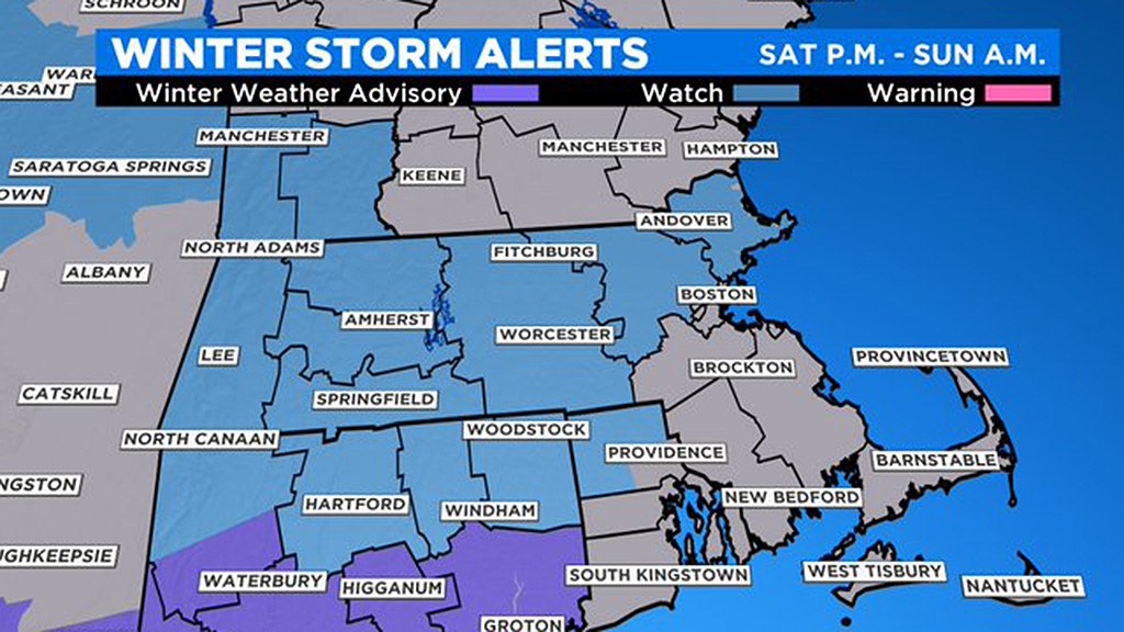
Those three counties, along with western Massachusetts, are under this watch as they are expected to record the higher snow totals in the state. The greater Boston area and southeastern Massachusetts are not in this category as of now.
WEEKEND SNOW
A shield of snow will move in late in the afternoon. It will begin to fall between 4 and 7 p.m. from west to east across southern New England. This will be a very quick burst of snow, lasting only about 6-to-8 hours, tapering off to flurries around midnight.
There will also be a mix and change to rain in areas south of the Massachusetts Turnpike, so snowfall amounts will be lighter and in many cases, washed away in those areas.
The storm is long gone by Sunday morning, just a few remaining sprinkles or flurries in the air.
HOW MUCH?
A coating to 2 inches: South Coast, Cape Cod and the Islands, mostly washed away by a fairly quick change to rain.
2-to-4 inches: North of Plymouth up to Boston, including most of Norfolk County and northern Plymouth and Bristol counties, also directly down the Mass Pike area from Boston to Worcester. A change to rain here will compact the snow quite a bit.
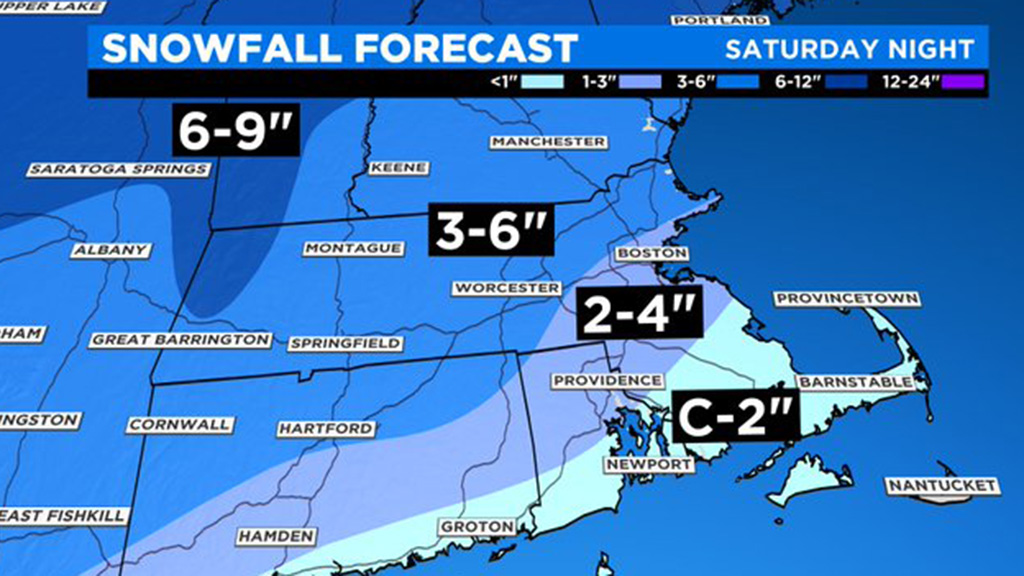
3-to-6 inches: All areas north of the Pike, this includes northern Worcester County, most of Middlesex and Essex counties and southern New Hampshire.
OTHER CONCERNS
This one is basically just a quick hitting thump of snow, no wind or coastal concerns. The main hazard will be slippery road conditions Saturday evening and night due to a light to moderate snow accumulation.
WHAT'S NEXT?
No big storms in sight after this weekend, but temperatures are likely to be below average for most of next week. So any snow accumulation that remains on Sunday will likely stick around for a while.
Follow Terry on Twitter @TerryWBZ


