Icing Possible As Sleet, Freezing Rain Fall Until Tuesday Morning
BOSTON (CBS) - A storm system bringing a wintry mix of precipitation moved into the area Sunday night and will continue until late Tuesday morning
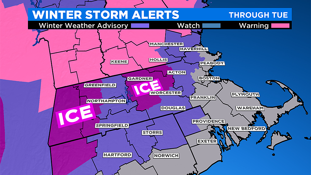
The WBZ Weather Team has issued a Storm Watch Weather Alert and the National Weather Service has issued a Winter Weather Advisory and an Ice Storm Warning as depicted on the map valid into early Tuesday. Precipitation will vary depending on location and surface temperature.
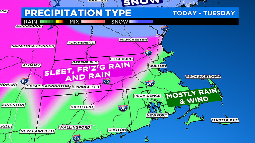
It will not be a classic snow producer in much of the region. Instead, due to the influx of milder air aloft and colder air draining in at lower levels, the precipitation will be in the form of primarily sleet, freezing rain and rain. Some snow may be mixed in at times mainly across northern Mass. but most of the accumulation will occur farther north near and north of the MA/NH/VT border.
The greatest impact from this storm will be the potential for an ice storm from the Berkshires eastward into north central Mass. and northward into southwestern New Hampshire and southern and central Vermont. The jackpot spots of the biggest ice accretion will likely be over the eastern slopes of the Berkshires and parts of northern Worcester County into northwestern Middlesex County.
A buildup of ice to a quarter-to-half inch is quite possible in these areas prompting the potential for scattered power outages! Outside of these spots, ice thickness will range down less than a quarter-inch to just a glaze.
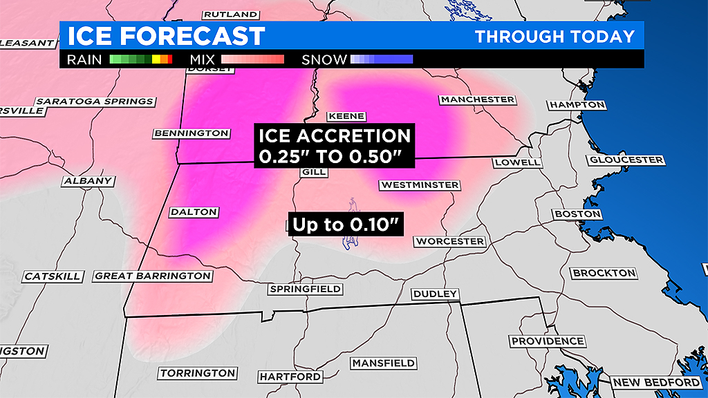
All it takes is a GLAZE of ice to create dangerous and slippery conditions. Be extra cautious in walking and driving in some of the western suburbs and especially west and north.
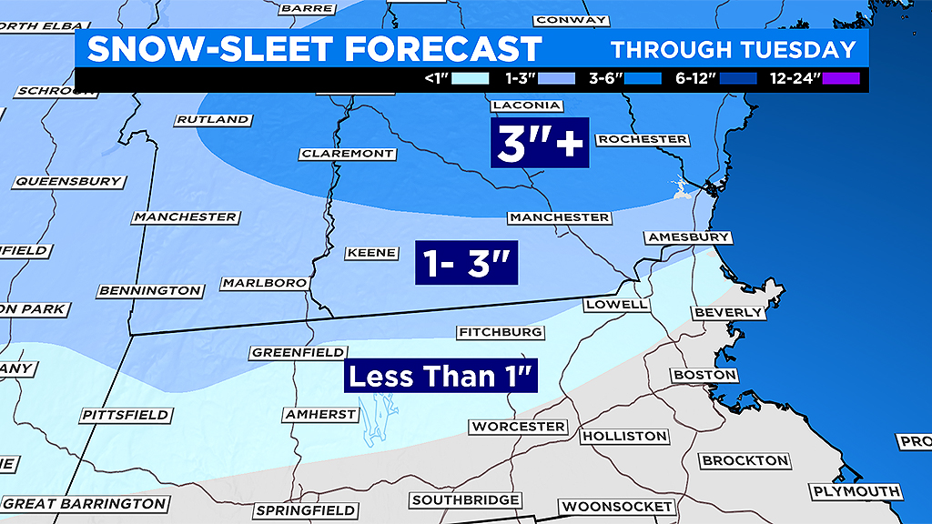
The plain rain zone will push slowly northwestward across the Mass Pike and west of Boston Monday morning but the icing in central Mass. will be the main problem as the heaviest precipitation will likely occur Monday morning then the intensity will become lighter in the afternoon and overnight into Tuesday morning before ending. The highest amounts of snow are most likely across east central NH into interior western Maine where more than 6 inches could accumulate in places.
The wind will not be a big factor but it will be the strongest Monday afternoon and evening along the coast. Maximum gusts of 15-25 from the east-northeast will occur over most inland locations with 25-40 mph gusts along the coast. A few gusts of 45-50 may occur over the outer Cape.
Once the weak secondary storm passes over southeastern MA and the Boston area later Tuesday morning and tracks over the Gulf of Maine in the afternoon, the precipitation will taper off and a few breaks in the clouds could occur by dusk so it should be drying out for New Year's Eve celebrations and there will not be an arctic blast this year.
Expect a temperature near 35 degrees as 2020 begins Tuesday night. January 1, 2020 will feature a mix of clouds and sunshine with a brisk wind and high temperatures in the lower 40s.
Check for updates on WBZ-TV, here at CBSBoston.com and streaming on CBSN.
HAPPY NEW YEAR!


