Heavy Snow Bands Make Morning Commute Around Boston Treacherous
BOSTON (CBS) -- Had enough of winter yet? Three days into meteorological winter and we have already had hundreds of school closings and numerous slippery commutes and we'll do it all over again Tuesday.
The main course from part two will come between 4 a.m. and midday on Tuesday. This is when the storm will make its closest pass offshore and when we are most concerned about significant additional snowfall in eastern Mass. There will be some very heavy/intense snow bands on the western edge of this storm, which will come perilously close to our coastline.
NEW SNOW ACCUMULATION:
Through midday Tuesday:
1"-3" Far away from the storms center, Western Mass., Vermont and up into Central and Northern New Hampshire.
3"-6" All of Central and Eastern Mass. from Worcester County eastward and all of southern New Hampshire and Maine.
WINDS:
Northerly gusts along the coastline on Tuesday morning will reach 30-50 mph (similar to today). . . but combine those winds with some heavy snow and you could get near whiteout conditions at times during and after the Tuesday morning commute. Once the snow tapers and the storm begins to pull farther out to sea, the winds will gradually diminish through the overnight hours.
SNOWMELT. . . OR NOT:
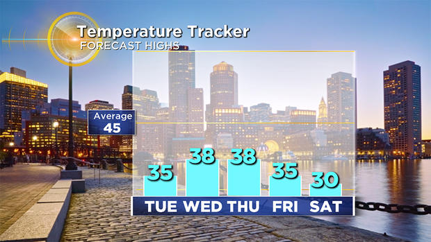
Temperatures for the remainder of the week will top out in the 30s for highs so no immediate or significant snowmelt. There are signs of somewhat milder air next week, but for now it appears we will keep our new blanket of white.
Follow Terry on Twitter @TerryWBZ


