Bomb Cyclone Sets Record As Strongest October Storm Ever In Boston Area
BOSTON (CBS) -- An intensifying coastal storm bombed out overnight and brought flooding rain and damaging winds to the area.
Low pressure rapidly intensified as it moved up the coast into the northeast late Wednesday into Thursday. The storm's central pressure plummeted 30 millibars in only 15 hours from late Wednesday morning to early Thursday morning.
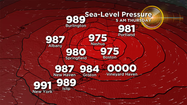
The definition of a 'bomb cyclone' is one that drops in pressure by at least 24 millibars in 24 hours or less. As this storm intensified, the central pressure dropped to a new record for lowest pressure during October in our area.
The strongest winds were along the east and south coast. Up to 90 mph gusts were observed in Provincetown. Logan Airport reported a wind gust of 70 mph. Wicked winds downed numerous trees, limbs and power lines. Over a half-million residents lost power in New England, according to poweroutages.us.
Photo Gallery: October 17 Storm Damage
Sustained Category 2 hurricane-force winds were observed atop Mount Washington early Thursday morning.
FORECAST:
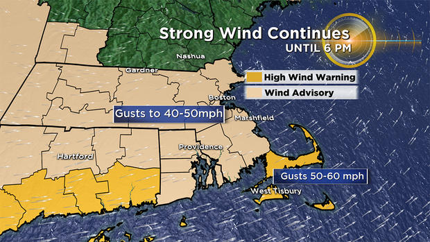
The core of the strongest winds have moved north and out of southern New England, however strong to damaging winds will linger through Thursday. A High Wind Warning is in effect for Cape Cod and the Islands until 6 p.m. for gusts up to 60 mph. A Wind Advisory is in effect the rest of the state for gusts up to 50 mph. Clean-up will be hampered by the strong winds. Crews attempting to restore power may have trouble getting buckets up with winds like this as well. I'd also expect more tree damage and potential power outages through the day.
After a widespread 1-3" of rain with areas of flooding, more rain showers will impact the area Thursday.
The heaviest rain will be in northern New England, but gusty showers may rotate across the state on the backside of this storm system. Some wet snow may even mix in across the higher terrain of central and northern New England.
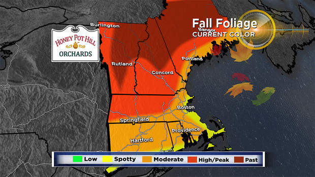
The rain and wind will also strip away some fall foliage in parts of New England. Portions of New England are currently experiencing peak color. Be aware of leaf-clogged drains and ponding on the roadways if traveling.
The storm will continue to pull away the next 24 hours, leading to drier conditions Thursday night into Friday. Breaks of sun are expected to finish off the week. There will still be a noticeable breeze, but winds diminish through the day. The weekend is looking calmer and brighter.