Hurricane Dorian Grazes Cape And Islands On Its Way To Canada
BOSTON (CBS) - Hurricane Dorian is on its way to batter the shores of Nova Scotia and Newfoundland this weekend. Maximum sustained winds decreased to 85 mph Saturday morning as it passed about 145 miles southeast of Nantucket.
As with all tropical systems headed northward through the Atlantic, Dorian will begin to undergo a metamorphosis from tropical to extra-tropical as it passes over much colder waters. The winds will slowly decelerate but actually spread out wider from the center, as is typical in hurricanes gaining latitude. It strengthened to a Category 2 storm Saturday afternoon.
Southeastern New England caught the northwestern flank of Dorian early today with wind gusting past 50 mph at times especially on outer Cape Cod and Nantucket.
TIMELINE:
The main band of rain associated with Dorian left the outer Cape around 8 a.m. and most areas will have no more rain today. As Dorian accelerates well past our latitude later Saturday, the wind, rain and clouds will go with it. So expect clouds giving way to a decent supply of sunshine and some clouds from west to east as the morning progresses and it will be delightful but still breezy this afternoon.
RAINFALL:
The highest rainfall totals were in areas closest to the storm, namely Cape Cod and the Islands. The amounts were mainly in the range of 1-to-2 inches over most of the Cape with up to 2.5 to 3 inches on Nantucket.

Elsewhere, amounts were only a few hundredths of an inch except a few tenths of an inch near the South Shore and also in a separate band from southwestern New Hampshire into northwestern Massachusetts.
WIND:
The strongest winds occurred over the outer Cape and Nantucket early Saturday when gusts of 53-63 mph were reported. Expect wind gusts to decrease to 20-40 mph there the rest of the morning blowing in from the north then northwest as the storm center races away from the region.
A Tropical Storm Warning remains in effect over Cape Cod and the Islands but will likely be discontinued by midday or early afternoon. Some minor tree damage has been reported on the Cape.
Over the rest of the region, the wind will range from 15-30 mph along most of the coast to 10-20 mph inland into the afternoon.
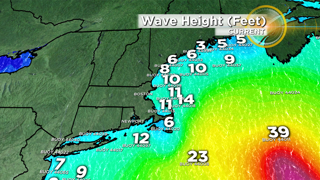
SEAS:
The ocean will remain rough throughout the day as Dorian approaches Nova Scotia. The wave heights will build a bit more up to 8-14 feet crashing on many of the New England beaches with 15-20+ foot seas offshore. Thanks to lower scheduled high tides this month, most areas did not experience any coastal flooding but some beach erosion is anticipated.
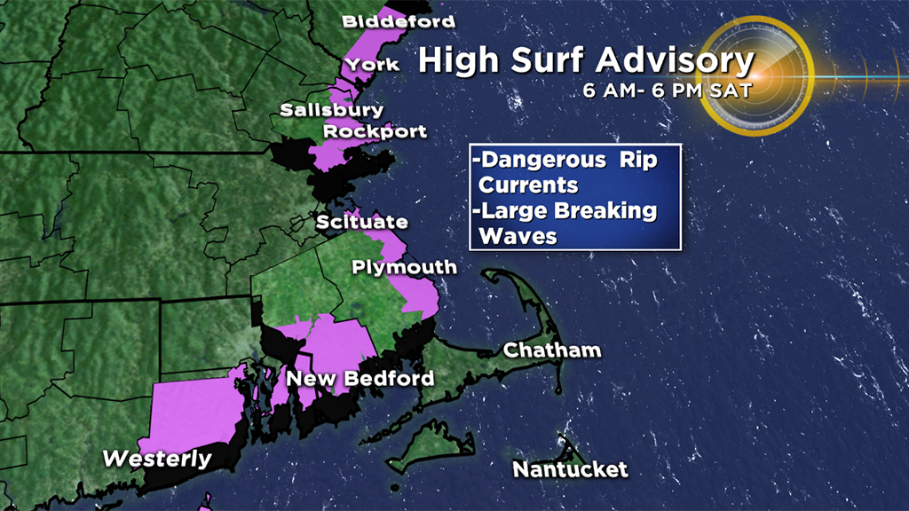
These large waves always draw people to the coast during an event like this, but be aware, those waves will be dangerous to anyone entering the surf, venturing out on jetties or viewing from sea walls. Spectators should stay in safe areas, away from possible splash over. The risk of rip currents will also be very high. A high surf advisory has been posted for parts of the area through today.
As always, we urge that you stay tuned to WBZ-TV and CBSBoston.com for weather updates.


