Snow Storm To Hit During Evening Commute, Change To Ice And Rain
BOSTON (CBS) -- It seems this is the winter of slop in Southern New England. What happened to the days of pure powder and "fluff factor"? The main challenge with just about every storm we have received this year has been timing the arrival of warm air (aloft and at the surface). The biggest question in past storms and again with this storm, how much snow can we get on the front end before the change to ice and rain.
The most significant difference with this storm will be the timing. Most, if not all of our snow has come at night thus far. Think about it, how many times have you actually seen or watched the snowfall during the daylight hours?
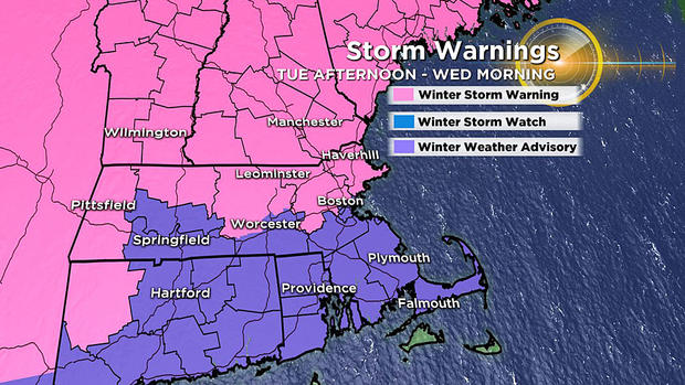
Tuesday's storm has a serious case of bad timing. While the majority of the snow will fall within a brief three to five-hour window, it just happens to be centered around the evening commute.
TIMELINE:
The snow arrives first in the far west and southwest New England (Connecticut and the Berkshires) between noon and 1 p.m.
Between 1 p.m. and 3 p.m., it will hit the rest of southern New England.
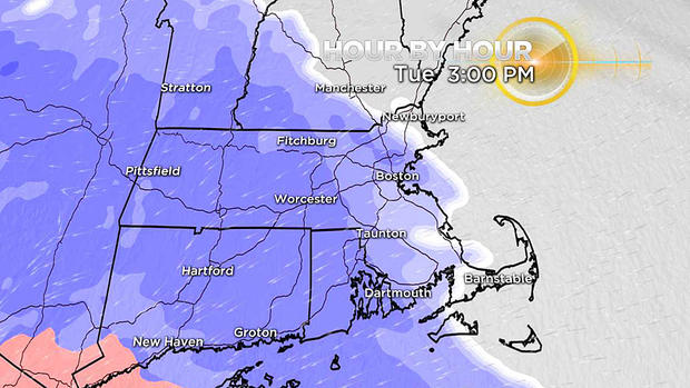
Between 3 p.m. and 5 p.m. snow will make its way to central and northern New England. The snow will come down at a pretty good clip for about three to five hours. Rates of an inch per hour are possible between 3 p.m. and 7 p.m. Tuesday.
It quickly becomes a sleet-fest…
First signs of changeover come along the South Coast & Cape, literally about an hour or two after the snow starts.
By 6 p.m. to 7 p.m., sleet is covering most of southern New England, the last to change over will be Essex County and southeast New Hampshire (between 7 p.m. to 8 p.m. there).
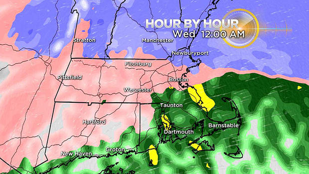
The milder air keeps on comin'…
Gradually, overnight the sleet changes to rain in all of southern New England except for central and western areas (Worcester county and Berkshires). The elevated hills of Worcester and the Berkshires will likely never warm enough at ground level to change to plain rain, but instead, the sleet will gradually change to freezing rain in those areas.
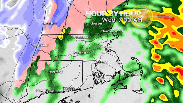
By dawn on Wednesday, the rain/freezing rain is tapering off. There will be very little precipitation left falling for the Wednesday a.m. commute.
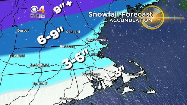
SNOW AMOUNTS:
Just about everyone in southern New England gets a quick thump of snow…lots of 3", 4" and 5" totals.
1-to-3 inches: Just south of Boston to Providence and all areas south and east…lowest over the Cape and Islands where the snow will change to sleet very quickly. All of this snow will be compacted and washed away by the change to rain overnight
3-to-6 inches: Boston down the Pike to Worcester and all areas north and west (closer to 3" near 128) and closer to 6" in areas north and west of 495. While this won't all be washed away, it will be severely compacted by the sleet and rain to follow.
6-to-9 inches and up: The jackpot once again falls in central and northern New England where it has been an entirely different kind of winter this year! Ski areas rejoice (again)!
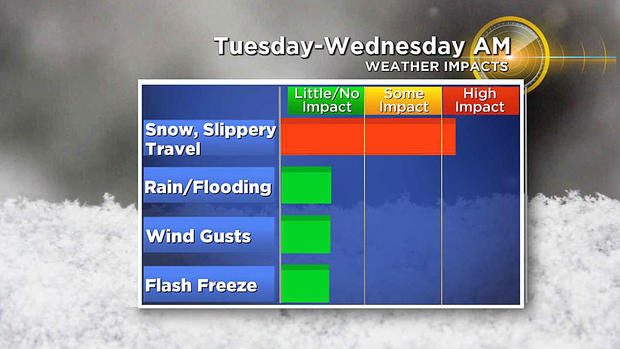
OTHER CONCERNS:
No coastal flooding concerns, no inland flooding concerns and also no flash freeze worries. The air behind this storm is actually quite mild. Temperatures will be 40+ Wednesday through Friday allowing plenty of time for cleanup and melting. The strongest winds will likely come after the storm. A gusty westerly wind will develop Wednesday, but again with temperatures in the 40s in eastern Mass., it won't feel all that bad.
We are a tad concerned with the freezing rain in central and western Mass. late on Tuesday. There could be some ice accretion (build up) on wires and trees, but this doesn't appear to be a major ice storm by any means.
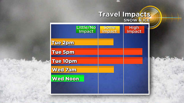
So if you can avoid traveling Tuesday late afternoon and evening, it would be smart to do so. I anticipate lots of evening school closures (afternoon and evening activities) and perhaps some delays on Wednesday morning (especially areas north and west). Best time to shovel/snow blow would be right when the change to sleet occurs, say around 6 p.m. to 8 p.m. Tuesday.