From A Deep Freeze To Flooding And 50's
BOSTON (CBS) - The arctic tundra of New England is about to have a spring fling. Just another week of weather in New England!
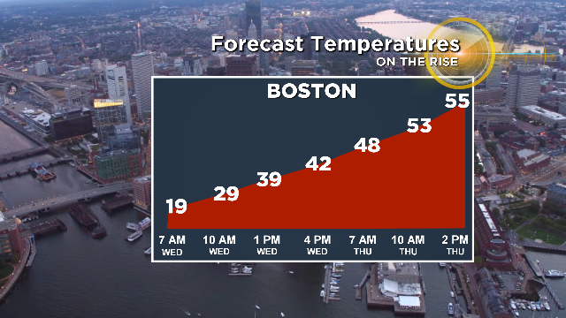
The bitterly cold air which led the week is giving way to a strong push of mild conditions, allowing temperatures to skyrocket from subzero Monday night to the mid 50s by Thursday. As is often the case, you can't change things that dramatically without some 'weather' in the middle and such is the case as we head into the middle of the week.
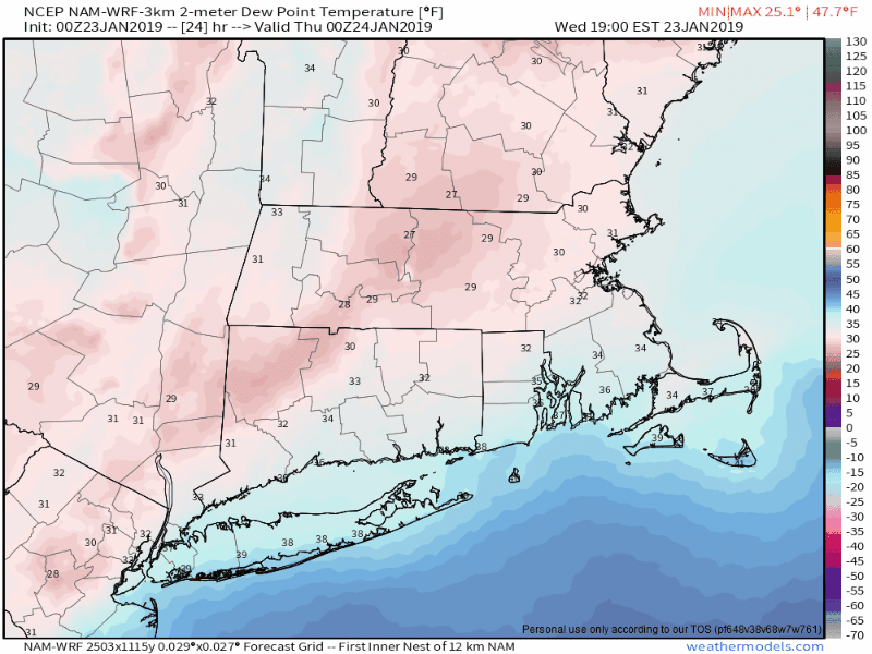
Put away the chapstick for a day...dewpoints will be on the rise!
I think a lot of New Englanders enjoy some snow on the ground in January, but what we've got now is borderline useless. It's a thick, unmovable glacier of wintry mix that's turned into concrete. Sidewalks are a mess and some roads are still in rough shape from the weekend. Let's ditch it. With dewpoints climbing into the 40s and 50s we will have some efficient air to chew up ice and snow. As this really begins in earnest Wednesday night, you can expect a lot of fog to develop. It'll be a murky and mild night as temperatures continue to rise even with the sun down. Expect some poor visibility if you'll be out on the roads.
As the melting begins, be wary of falling ice coming off of cars and buildings. Some pretty heavy slabs will likely be on the move. We'll also have to keep a close eye on pipes. The ones that froze and were damaged during the severe cold will show their vulnerabilities when the temps climb. I expect we're going to hear about some bursting pipes scattered around the region. It's also prime pothole producing weather this week - oh the joys of winter!
Graphic: WBZ-TV
By the time we wake up on Thursday most towns will be in the 50s. Typically in midwinter it's difficult to really push mild air inland across the interior, but this doesn't look to be one of those cases. There is little resistance to a stout southerly wind that'll bring the upper 40s to low 50s even into the NW suburbs of Boston. Around the city mid-50s are possible for highs, marking a 55-degree turnaround from Monday!
Graphic: WBZ-TV
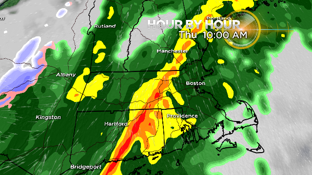
It won't be 'enjoyable' mild weather though. Showers will begin to break out by Wednesday evening and will be with us overnight, though generally scattered and on the lighter side. As we head into Thursday morning, the heavy stuff will be moving east into our area. The majority of our heavy rain falls Thursday morning through late afternoon as a band of downpours swings across southern New England. Embedded in this band could be a low-topped squall line with thunder and lightning. We'll have to watch this fine-line of convection carefully because it will have the potential to bring down some damaging wind gusts (50mph+) to the surface.
Graphic: WBZ-TV
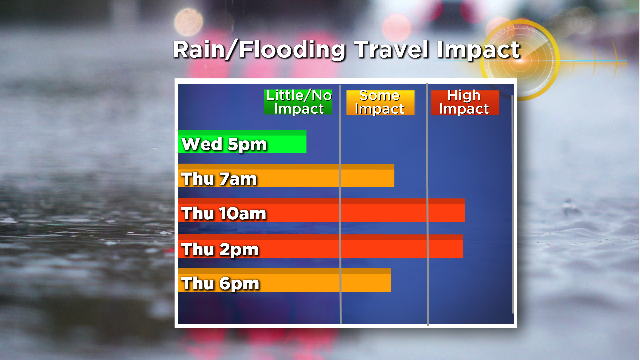
The system looks to bring a widespread 1-2" of rain with some localized 2"+ amounts possible. Combine that with a frozen ground which is, in turn, covered in a rock-solid icy crust and you've got some flooding issues. I'd expect a lot of standing water around the region on Thursday having difficulty draining away. Then as we head into Thursday night, temperatures will settle back into the 20s. It doesn't look rapid enough for a 'flash freeze' situation but it will definitely get icy overnight into Friday morning.
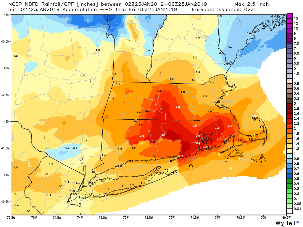
A widespread 1-2" of rainfall expected but some localized totals up to 3" are possible. Forecast: NWS Boston
How much snow will be left after it? Hard to say. It's always tricky to beat up a snowpack that's really made more of ice than snow. It looks like we should be able to erase most of it in the immediate Boston area and across southeastern Massachusetts. Across the interior, some snow and ice should remain but it will be a lot easier to chip away at and move around on Friday. Highs will reach into the 30s so there will be some additional melting after the overnight freeze.
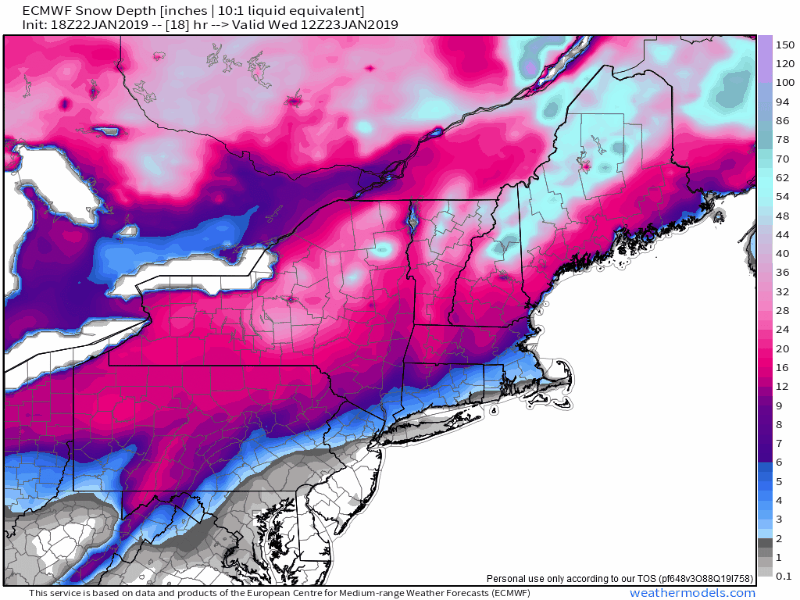
Projected snow/ice loss with this system


