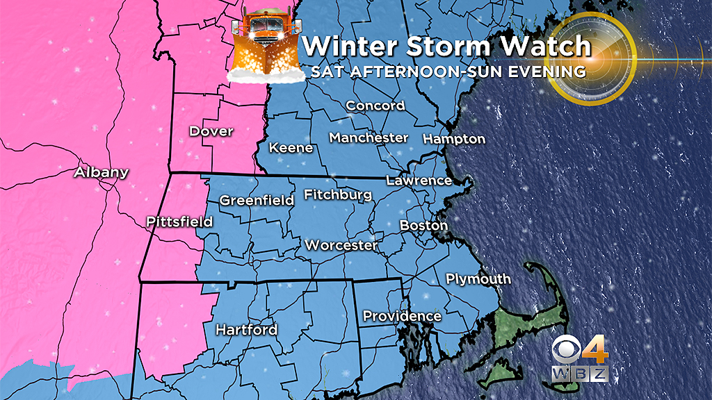
Major Winter Storm Could Bring A Foot Of Snow Or More To New England This Weekend
BOSTON (CBS) - Gas up snowblower. . . check.
Shovels. . . check.
Stock fridge with favorite beverage. . . check.
And away we go. Welcome to winter 2019. Anything that has happened this season up until now - forget it. Real winter is about to arrive. No easing in, no practice, we are heading right from "least snowiest winter on record so far" to "major winter storm on the way." Winter is funny that way. You can catch up for lost time in a hurry. Winter 2019 is about to go from zero to 60 faster than your favorite sports car.
OK, OK, I hear you. Enough puns and bad analogies. Let's get right to it.
FIRST FLAKES
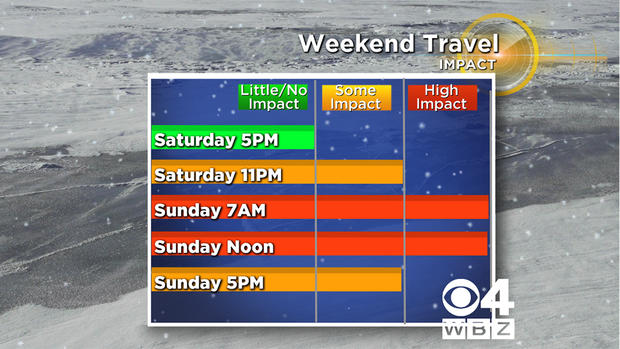
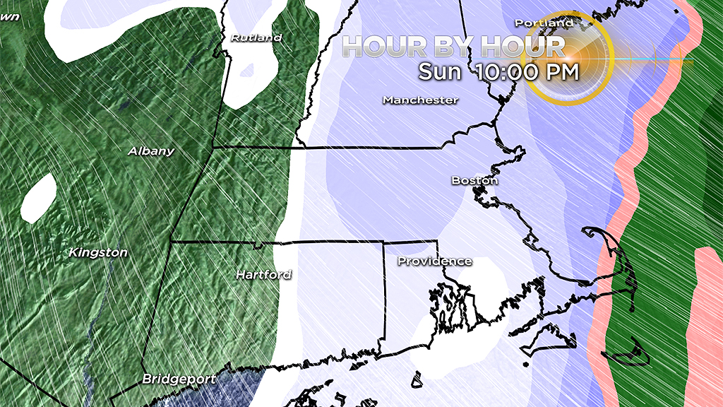
The snow will begin after 8 p.m. from west to east across the area. While there may be a few stray flurries from 4-8 p.m., nothing significant will fall before 8 p.m.
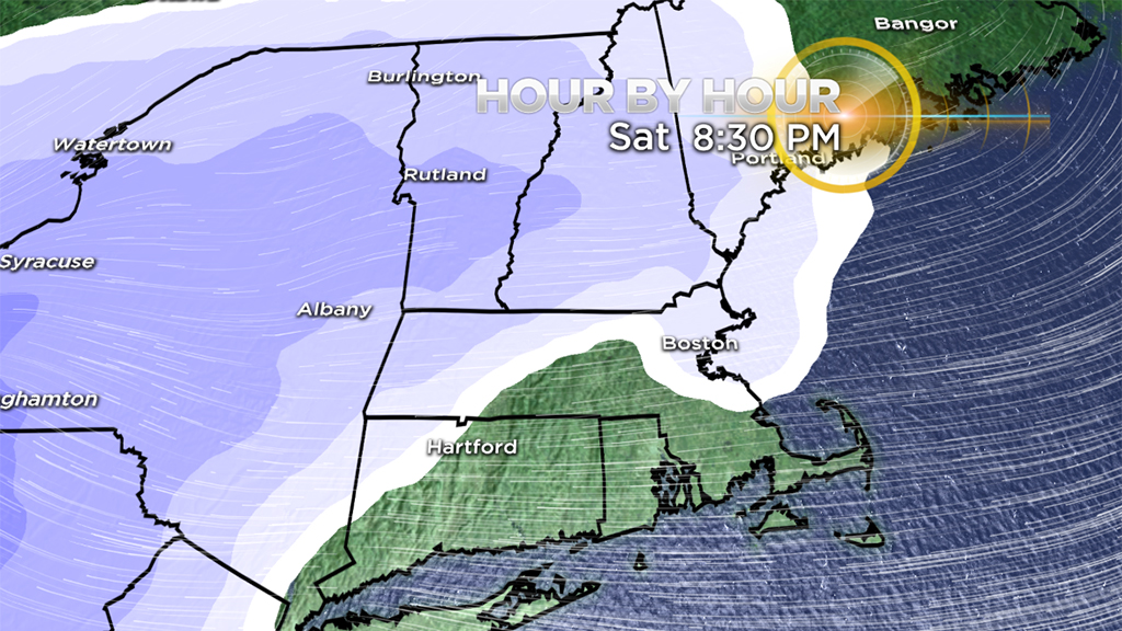
If you have Saturday night plans, the safest bet would be to get home by 10 or 11 p.m. There should be very little snow accumulation before then. After 11 p.m., all bets are off. The snow will quickly become steady and heavy, and the accumulation will mount up fast.
THE BRUNT
The majority of the snow accumulation will occur between 11 p.m. Saturday and 7 a.m. Sunday.
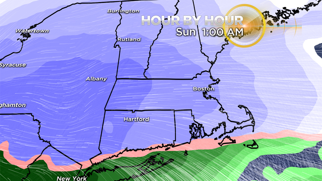
A rather small window, but snowfall rates of 1-to-2 inches per hour are possible for several hours within that time period. The key to the snowfall forecast is how fast the warmer air moves in at upper levels of the atmosphere (how quickly the snow changes to sleet).
THE CHANGEOVER
The areas to change over first are, of course, the areas where we expect the least amount of snowfall.
Midnight-3 a.m: Change from snow to rain along the South Coast and Cape Cod.
3-6 a.m: Change from snow to sleet and rain in Plymouth around 3 a.m. to just about the Massachusetts Turnpike by 6 a.m.
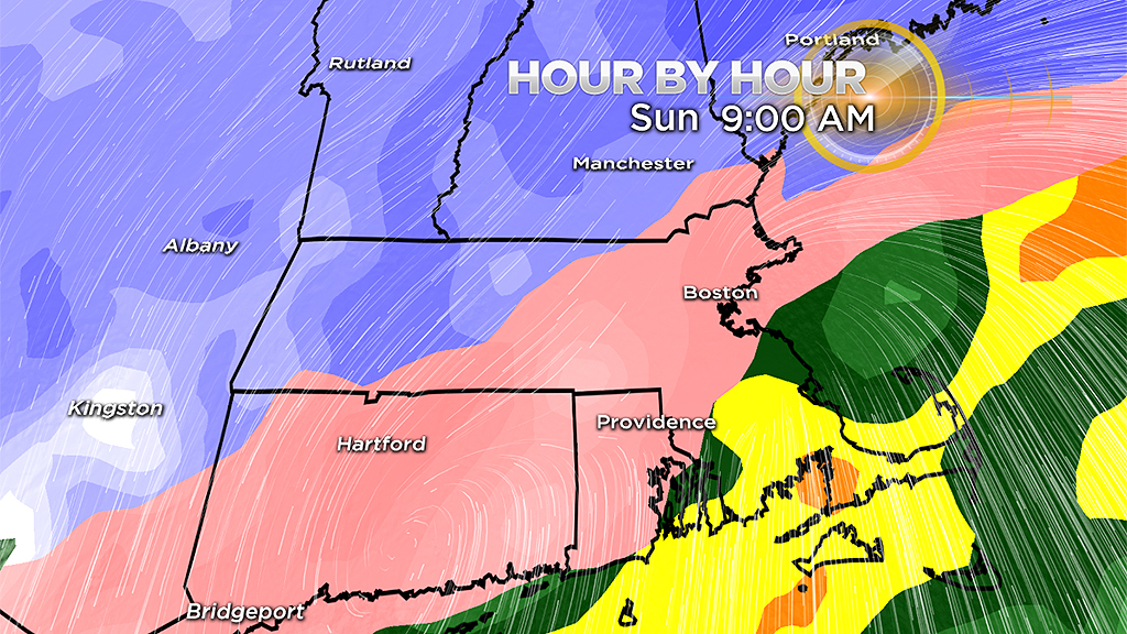
6-9 a.m: Rapid changeover for nearly all of southern New England. Snow changes to widespread sleet for all areas north of the Pike in north-central and eastern Mass. into southern New Hampshire. Areas north and west may stay all snow.
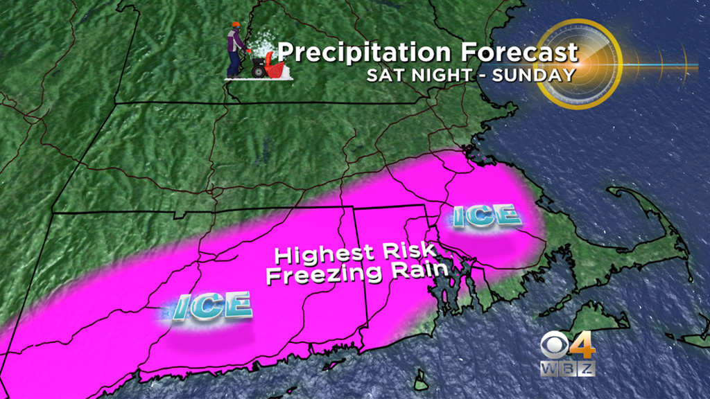
FREEZING RAIN
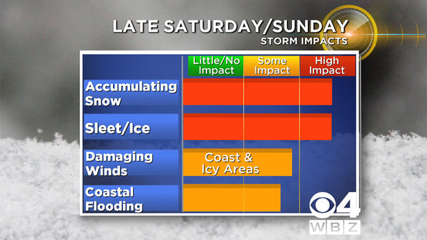
We are very concerned about a significant amount of freezing rain for parts of the area with this storm.
What is the difference between sleet and freezing rain?
Sleet is basically small pellets of ice. It falls and can accumulate much like snow (although not nearly as readily). It isn't all that dangerous as far as icing goes, it just makes a mess and it will compact and add weight to the snow pack already on the ground.
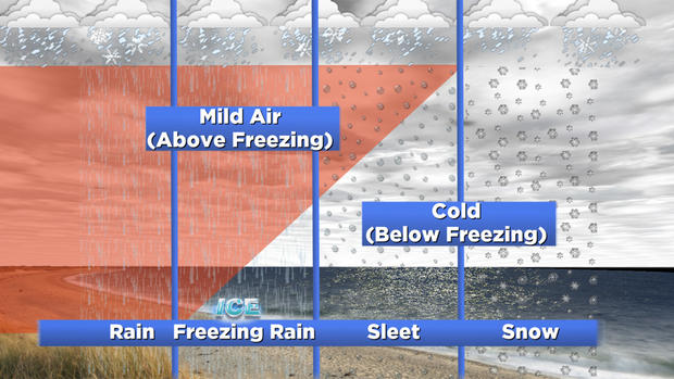
Freezing rain falls in the form of water, just like regular rain. However, it freezes on contact with the ground (and anything on the ground), putting a glaze of ice on everything. Freezing rain can accrete on wires and limbs, adding lots of weight and potentially leading to widespread power outages and damage. Think back to those nasty ice storms of the past when power went out for days and weeks, that was almost certainly due to freezing rain.
The area of greatest concern for freezing rain on Sunday is south of Boston, including much of inland southeastern Massachusetts, Rhode Island and Connecticut.
THE END
Again, the majority of the snowfall accumulation wraps up by late Sunday morning. The heaviest precipitation (mainly rain and sleet after 9 a.m.) tapers down between midday and mid-afternoon on Sunday. As the storm passes by late Sunday afternoon, some snow showers will wrap back into southern New England.
I'm not expecting much additional accumulation, but just be advised, the snow may not completely shut off until sometime Sunday evening.
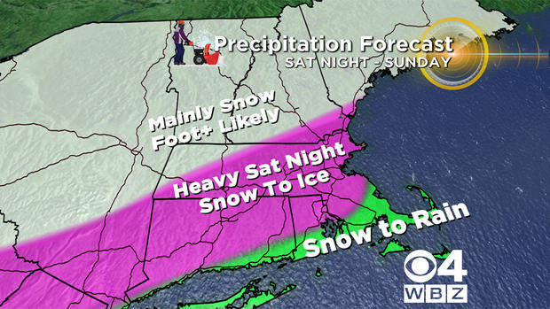
SO HOW MUCH?
Coating-2": Extreme outer Cape and Nantucket. . . mostly rain here, washed away.
2"-4": Plymouth to New Bedford and most of Cape Cod and Martha's Vineyard. Eventually washed away by rain.
4"-8": Areas north of a line from Plymouth to Providence, up to the Mass Pike, including Boston. Changes to rain or rain/sleet here and totals get severely suppressed in the end.
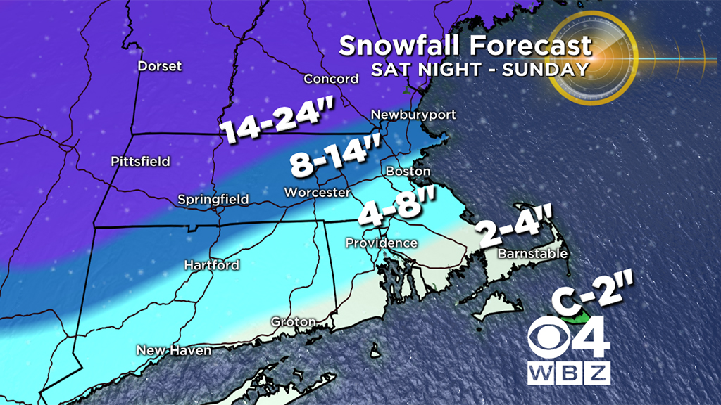
8"-14": Areas north of the Mass Pike, including most of Essex County, a big chunk of Middlesex County and most of Worcester County. This areas changes to sleet Sunday morning and while the snow won't go away, it will get compacted with ice on top.
14"-24": Ski country! Berkshires, southwest New Hampshire, extreme northwest Worcester County and all of central and northern New England. In fact, some elevated areas up north could see more than 2 feet!
GUSTY WINDS
Not much wind inland with this storm. The gusty and perhaps damaging winds will be mainly along the immediate coastline and more specifically over Cape Cod and the Islands.
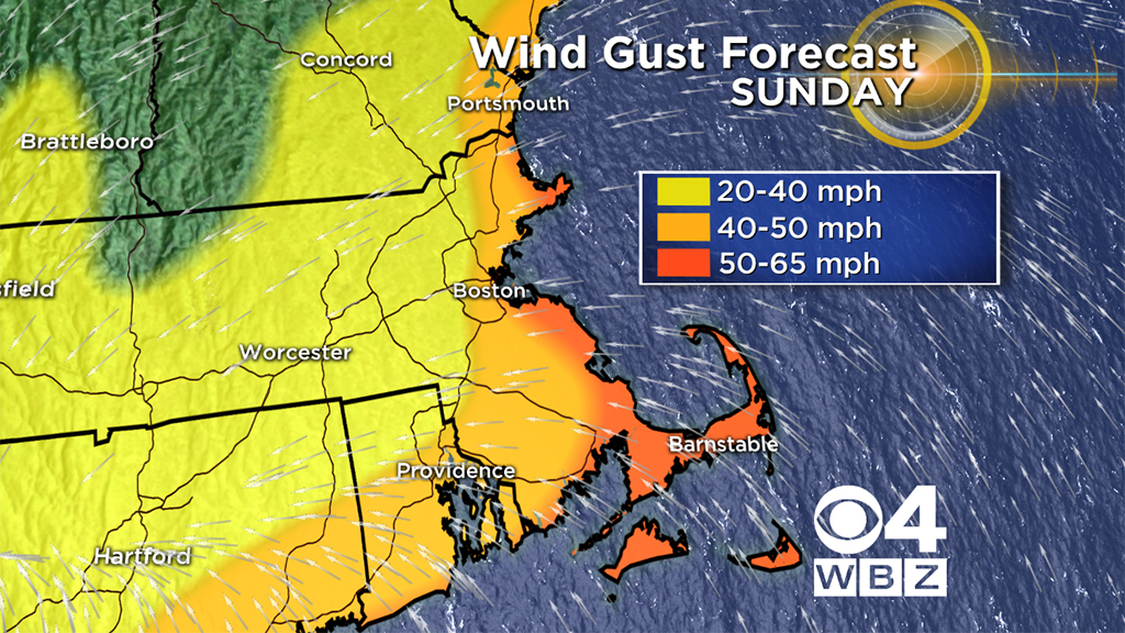
Gusts on Sunday morning will top out between 50-65 mph over the Cape and extreme southeast Massachusetts. Farther north, along the coast, gusts should top out between 40 and 50 mph. As the storm passes by and arctic air blasts in, the entire region will get gusts out of the north-northwest between 15-35 mph into Sunday night.
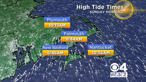
COASTAL FLOODING
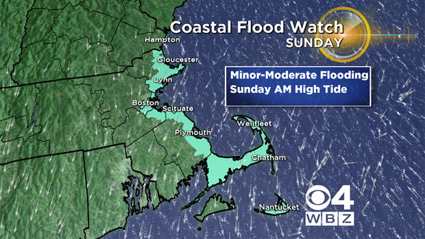
Given that there is a full moon this weekend, the tides are going to be astronomically high already. The main tide of concern is the Sunday morning high tide (between 9 a.m. and 11 a.m. for most).
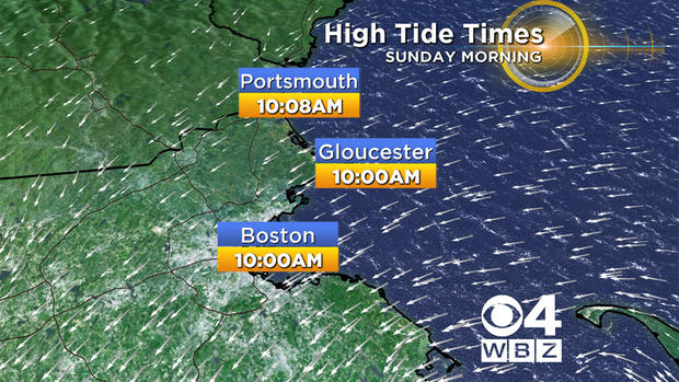
There will likely be some minor to moderate coastal flooding during this tide cycle along the Massachusetts east coast and perhaps also along the south coast of the Cape and Islands.
WHAT COULD GO WRONG?
This is a question we always ask ourselves as forecasters: What will the fly in the ointment be? At this point, the biggest "x" factor is definitely the sleet.
If the changeover happens earlier Sunday, the snow totals will be lower. If it takes a few extra hours before the sleet moves in, then the snow totals get a bit bigger.
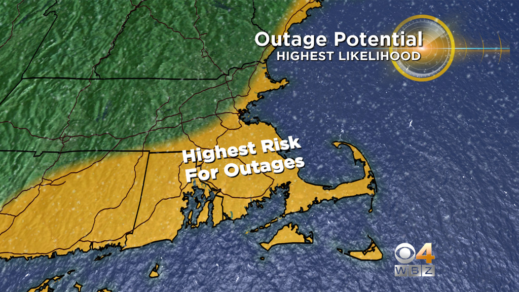
We are also somewhat concerned about scattered power outages. They shouldn't be all that widespread given the relative lack of strong winds inland, but with this amount of snow and ice and any amount of wind, outages are always a concern. There are going to be a lot of very angry folks if they spend all afternoon cleaning up and then lose their power right before the Patriots game comes on. . . ugh. Not to mention the severe cold air that is coming in right on the heels of this storm.
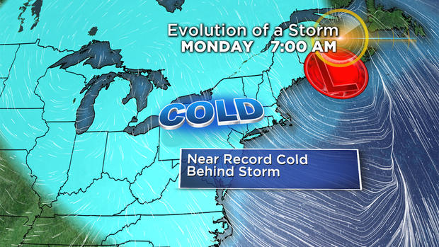
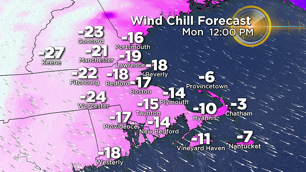
Temperatures will drop between -5 and 5 degrees late Sunday night and struggle to get out of the single digits on Monday. Going without heat will not be an option. Bitter cold wind chills will also be a concern, as it will feel like it is below zero for much of the day.
As always we urge that you stay tuned to WBZ-TV and CBSBoston.com for updates leading up to and during the storm! We've got you covered. Please stay safe.
Follow Terry on Twitter @TerryWBZ