Weather Alert: Flooding, Damaging Wind And Record Warmth Friday
Find Eric Fisher on Twitter and Instagram
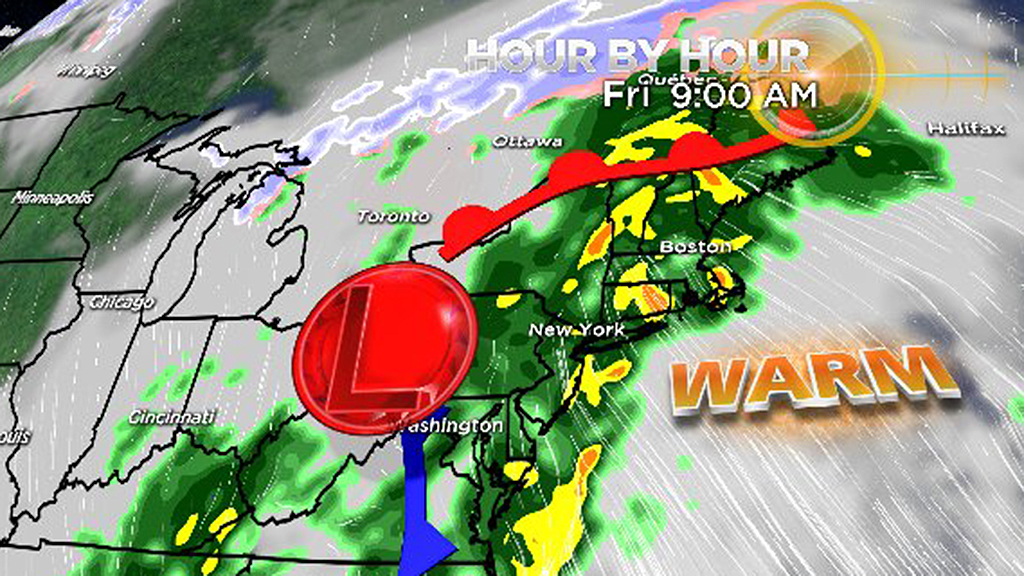
BOSTON (CBS) - The seemingly annual 'Grinch Storm' is on the way to New England, bringing a surge of tropical air and heavy rainfall just before the arrival of Christmas. This one will begin on Thursday night and continue into Saturday before settling back down to more seasonable conditions. With origins deep in the tropics, heavy rainfall and even a waterspout risk is expected to sweep into the area.
Rainfall:
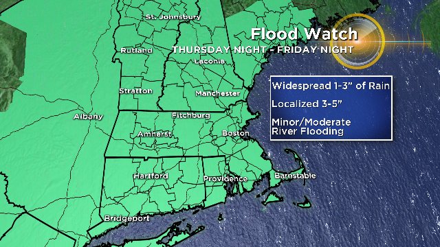
A Flood Watch is in effect from Thursday night through Friday night across all of the region. While a few showers will be possible after 9pm Thursday, heavier rainfall will start to arrive after midnight. Expect low visibility and areas of fog to develop. Throughout the day on Friday we'll be in and out of heavy downpours with embedded thunder and lightning. An isolated strong to severe storm can't be ruled out with damaging wind gusts and even some rotation. The heavy rain risk will continue until early Saturday morning, with a few more lingering showers during the day before we dry out and cool off on gusty northwest winds Saturday afternoon.
Graphic: WBZ-TV

Potential for river flooding Friday and Saturday. Yellow=Action state, Orange=Minor flooding, Red=Moderate flooding. More: weather.gov/erh/MMEFS
Rain totals of 1-3" are expected to be widespread, but some localized 3-5" rain amounts are possible. Poor drainage and nuisance street flooding will be likely creating difficult travel conditions at times. It's been a soaking year and we just came out of a record wettest fall, so all this rain in a short amount of time is likely to cause minor to moderate river flooding Friday into Saturday. Farther north, significant snow melt will add to the runoff into the Merrimack and Connecticut Rivers with ice jam flooding potential across far northern New England.
This storm should bring Blue Hill Observatory up to at least the 3rd wettest year on record, dating back to 1885. Also, keeping tabs on the state record for most rainfall in a year. Kingston, MA is currently just 3.58" below the all-time record in Massachusetts.
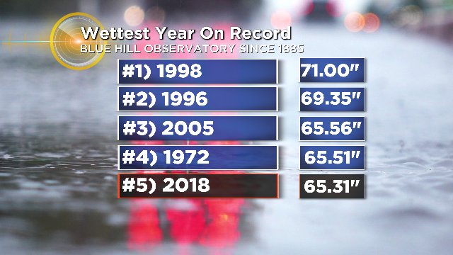
Standings for the wettest year on record at Blue Hill Observatory. Graphic: WBZ-TV
Damaging Winds:
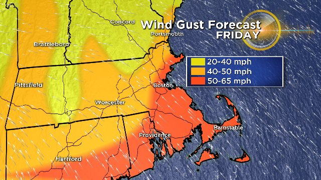
Winds will begin to increase on Friday morning with the potential to become damaging late in the afternoon through the first half of Friday night. The extent of the strongest winds depends on exactly how warm wet get. If temperatures can reach the low to mid 60s, gusts 40mph+ will be very widespread. If we hold in the 50s to near 60, it will be harder to 'mix down' those peak winds which will be roaring just above our heads.
Graphic: WBZ-TV
The highest overall risk of damaging winds is across southeastern Massachusetts, especially Cape Cod and the Islands. South-southeast gusts 50-65mph are likely here. We currently expect some gusts to top 50mph along all of the coast, with 40-50mph peak gusts farther inland. Areas of power outages and tree damage would be likely with gusts of this strength. As we saw last October, trees tend to fall more easily on a strong southerly wind than a northerly or northwesterly wind due to the former being a more rare event.
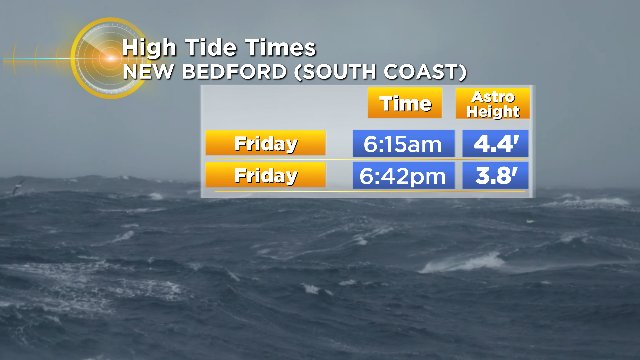
Coastal Flooding:
Minor coastal flooding is likely, especially along the South Coast on Friday during high tides. The due south winds will pile up water along the South Coast but that wind direction won't produce anything overly disruptive along eastern facing shores. The most vulnerable spots could see minor flooding as well as splash-over. Remember, coastal flooding can begin a couple hours before high tide and last a couple hours after.
Graphic: WBZ-TV
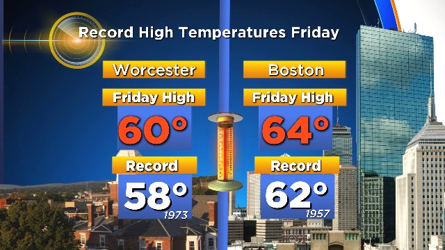
Record Warmth And Snow Melt:
Ironic that the warmest day of the month will be the winter solstice! Highs are expected to reach 58-65F on Friday with a muggy feel. This should be enough to set new records in both Boston and Worcester for the date. Normal highs for late December are around 40 degrees.
As for the snow pack - there isn't any! Well at least here locally. There is a blanket of snow in parts of the Berkshires otherwise you have to head north. This storm will likely melt just about all that's on the ground in the Berkshires, except perhaps a few of the best holdout spots. Across northern New England, we'll probably see most of the lower elevations lose all of their snow with a good chunk taken out of the higher elevations where there's over a foot on the ground currently.
High dewpoints are effective at melting snow. This will also make for very foggy conditions across northern New England Friday into Saturday morning.
The most effective way to melt snow is high dewpoints, and we should see them reach the 50s for a time late Friday into Saturday morning. There will be a lot of snow loss and about 1-2" of liquid equivalent joining forces with the rain as it melts out of the snow pack. If you're thinking about the impact on skiing - yes it's not ideal. But there was very solid snowfall in November and most areas have strong bases. They won't lose it all. Plus, we should turn to snow showers on Saturday as the cold air rushes in and it'll be plenty cold to get the snow guns going again by Saturday night. So while it's not what you want on the doorstep of Christmas, it could definitely be a lot worse!