A Big Year For Southern New England Tornadoes
Find Eric Fisher on Twitter and Instgram
It may not be the new tornado alley, but there have been times where it has felt like it! Monday brought several more confirmed tornadoes to the area in a setup that was nearly identical to the one which produced 4 tornadoes and multiple waterspouts last week. Some low-level instability and plenty of wind shear both bringing unusual late-October twisters. Is this something we should get used to, or just one odd year?
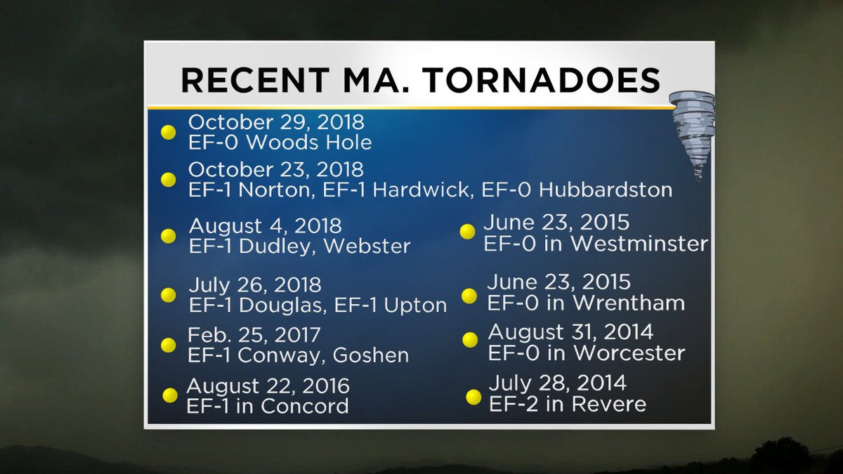
For starters, here's how things played out Monday morning. Storms firing up along the South Coast started to spin with ample low-level shear and the first tornado of the day came across tiny Fishers Island between the coasts of Connecticut and New York. There was significant damage on the island and a clear TDS (tornado debris signature) on radar as pieces of leaves and wood were thrown up into the storm.
Then, more rotation was evident on a storm which was approaching Martha's Vineyard. For a time, it actually appeared that there may be a pair of waterspouts out over the open water just off the western tip of the Vineyard. This was pared down to one area of rotation that skipped over Naushon Island and then moved into Woods Hole. The waterspout briefly came ashore at Woods Hole Golf Club with minor damage as an EF-0 tornado.
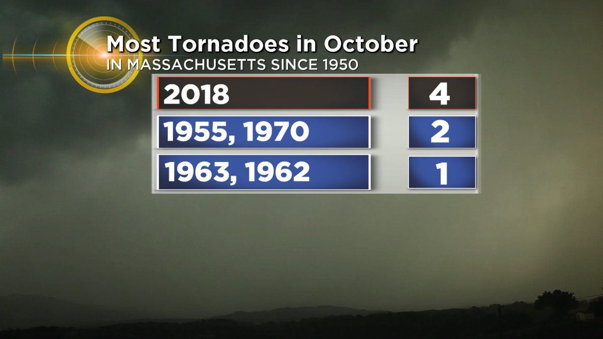
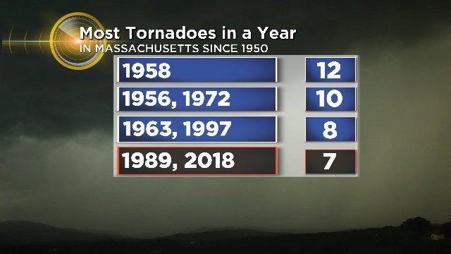
In addition to these two tornadoes, another EF-0 was confirmed in Stonington, CT. Last week, there were several in Massachusetts and one in Rhode Island, plus another 'unconfirmed' tornado in Sandwich. The waterspout there just barely nicked the sand on the beachfront. In short, it's been a busy October! We've had the most October tornadoes on record in Massachusetts, dating back to 1950. For the year, we have now had 7 confirmed tornadoes in the state.
Graphics: WBZ-TV
So what is the deal? Are we turning into a hotspot for tornadoes? Well there are at least two big variables to look at when trying to determine a trend.
Technology: We have an amazing capacity to document severe weather now versus any time in human history more than 10 years back. Nearly everyone has a fantastic camera in their pocket. Wherever a storm hits, there are usually photos and/or videos of it. This means that in general we are able to record more storms than ever before. This is particularly important for events like tornadoes, which are on such a small scale that many of them (especially the weak ones) were likely missed in the past.
On top of that, the development of dual-pol radar has changed the way we see storms. This is also why you are seeing more tornado warnings than in the past. This latest generation of radar gives us a deeper look into the storms than ever. It shows us when debris is being lofted and allows for additional/faster scans when in SAILS protocol, which the National Weather Service initiates when severe weather is a threat. SAILS allows for extra scans of the lowest levels of the atmosphere to watch rotation as it ebbs/flows in these fast moving situations.
Classification: Damage in the past was often called a tornado, even when it wasn't. Ted Fujitia, a pioneer of tornado classification, helped to explain the difference between twisters and a microburst (straight-line wind damage). We know that there are a lot of 'tornadoes' in the official database before this breakthrough in the 70s that were not actually tornadoes. So there is some inflation in the numbers there.
Graphic: WBZ-TV
Do the two balance each other out? We are recording and warning more than ever before, which gives us a slight upward trend in confirmed tornadoes. At the same time, the past numbers are inflated due to a mixing of microbursts and tornadic damage. But during that time, we were also missing several of them due to under-reporting. Weather detective work is hard!
The general consensus is that there is low confidence on any trend in tornadic activity in the U.S. as a whole. We have not seen any significant upward trend in tornadoes and climate predictions for the future are also unclear on the subject. We can say for sure that there has been a tremendous lack of tornadoes over the past several years, with 2018 near record lows for the Lower 48 and also a record 'drought' between the most violent EF-5 tornadoes.

Source: Storm Prediction Center
The practical forecaster (myself included) will probably say that in theory, a warming climate and warming ocean waters will likely lead to a northward creep in tornadic activity over time. We've noticed a slight trend, but it's not a major one at this time. As we continue to warm it should open the doors to tornadoes in 'odd' times of year (like late October, or last year's February twister in Conway, MA) with a more extended season. And we may see more activity in places like northern New England and southern Canada. Many of us have noticed that slight creep, though more years and data will be needed to show it conclusively.