Nor'easter Snow Totals Scaled Back, Power Outages Possible
BOSTON (CBS) - After passing the Mid-Atlantic to Long Island, our four'easter will have a somewhat gentler feel here in New England. Bands of wet snow will move through overnight, particularly across southeastern Massachusetts. But we won't have the big snow totals that other parts of the region picked up (nor will it be nearly as intense or damaging as the past several nor'easters!) Finally, catching a bit of a break.
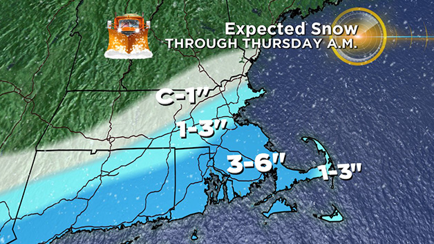
Dry air ate up a lot of the snow Wednesday evening, combined with a storm track that is a nudge farther south of Nantucket. This keeps snowfall totals in the 1-3" range east of Worcester toward Boston and the North Shore, with 3-6" totals across southeastern Massachusetts. Even a few inches of wet snow can cause power outages, particularly with gusts over 35mph. So that will continued to be monitored overnight.
During the morning commute, the highest chance of snow causing some issues will be toward far southeastern Mass., including Cape Cod and the Islands. As the storm pulls farther away we'll see some sunshine break out from west to east and with highs in the low 40s roads should end up in good condition.
Minor coastal flooding and splashover is likely with the high tide between 3 and 4:30 am, with more strong wave action and erosion for the one high tide cycles. Winds turn offshore on Thursday so no flood threat is expected for the following high tide.


